Guernsey was in fact two islands until the strip of water which isolated the major part of Vale parish was landfilled 200 years ago.
These days Rousse bay occupies the western end of what used to be the channel, while St Sampsons harbour is on the eastern coast where a bridge crossed the gap. This is how the Bridge, Guernsey's "2nd town", got it's name! There is now only marshland where the widest point of the channel would have been - it is called the Vale Pond, and is popular with bird watchers.
If you are interested in Guernsey's ancient fortifications, L'Ancresse common is the site of a few Martello towers, forts, and more recent German bunkers.
| Rousse Rousse tower is the westernmost of the Martello towers in the north and, as for the others, dates from the Napolleonic wars. Although technically not "Martello" towers, they are similar to their Moroccan namesakes. |
 |
 |
This model can be found in the old armoury at Rousse tower. Closest to the camera
is the Bridge and Vale Castle (the white blob!) At the top are the towers of L'Ancresse on the right, with Vale Church and Rousse tower on each side of the channel towards the left. |
| This view from Rousse tower shows one of the display cannon overlooking the bay. On the far headland is a 2nd tower which once helped to provide excellent protection from any Napolleonic invasion fleet. |  |
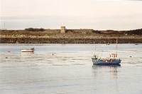 |
The tower on the northern side of the bay can be seen quite clearly here. For hundreds of years Rousse bay provided a safe mooring spot for many fishing boats. It is still well used by both commercial and hobby fishermen. |
| One of the flagship "Fortress Guernsey" sites, Rousse tower is well looked after and certainly makes itself seen at night. |  |
 |
L'Ancresse One of the nicest bays in Guernsey (alongside Cobo) is at the northern tip of the Island. Actually Pembroke and L'Ancresse, I'll just stick with the one name. L'Ancresse common is the site of one of Guernsey's main golf courses, and generally a very pleasant place to walk or drive. |
| This picture shows 3 of the 5 towers on L'Ancresse common (centre and 2 either side in the distance). | 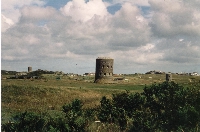 |
| Other sites of interest The Vale mill, as with the Old Mill in St Martins, lost its sails a long time ago. It is now part of a site of private flats with a superb view of Guernsey and out to sea in all directions. It is used by seagoers as a navigational landmark.
|
 |
 |
St Sampsons Harbour and The Bridge Guernsey's 2nd town, the Bridge, is in the distance. Southside and Northside are on the left and right respectively. The weighbridge clocktower can be seen in the centre. |