A Lotz Family Travel
Page
Copyright 1999 - 2004
by the Lotz Family
To the Smokies from Townsend
Two Scenic Drives
 So
far, our favorite place to stay when visiting the Great
Smoky Mountain National Park is Townsend, Tennessee. This area is aptly
advertised as the "Peaceful Side
of the Smokies" and that's exactly why we stay in Townsend. The commercialization
is orders of magnitude less than that of Pigeon Forge and Gatlinburg, TN.
Unless you have kids who want to do more than view and learn about the
Smokies, we suggest you get away from it all and check out the "Peaceful
Side of the Smokies". Even if your family wants to do something in Pigeon
Forge or Gatlinburg, it's a scenic drive on US Hwy. 321 North/TN Scenic
73 to Hwy. 441 South.
So
far, our favorite place to stay when visiting the Great
Smoky Mountain National Park is Townsend, Tennessee. This area is aptly
advertised as the "Peaceful Side
of the Smokies" and that's exactly why we stay in Townsend. The commercialization
is orders of magnitude less than that of Pigeon Forge and Gatlinburg, TN.
Unless you have kids who want to do more than view and learn about the
Smokies, we suggest you get away from it all and check out the "Peaceful
Side of the Smokies". Even if your family wants to do something in Pigeon
Forge or Gatlinburg, it's a scenic drive on US Hwy. 321 North/TN Scenic
73 to Hwy. 441 South.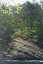 This highway runs through both of these towns and on into the park to North
Carolina as Newfound Gap Road.
This highway runs through both of these towns and on into the park to North
Carolina as Newfound Gap Road.
Access to the Park from Townsend is easy - just don't
turn left onto 321 / 73 North. Keep going straight on 73 and follow the
highway into the Park. Once inside the Park you will come to a "Y" in the
road at the junction with Little River Road and Laurel Creek Road, where
two prongs of the Little River join. Just before this junction, on the
left side, is a large parking area. We always pull over, get out of the
car, and enjoy the scenery of the Little River as it tumbles over and around
the rocks in the stream bed. The right fork (Laurel
Creek Road), goes to Cades Cove; the left fork (Little
River Road), goes to Sugarlands Visitor Center. Maps of the area are available
on the right and left fork pages.
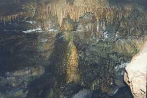
By the way, a stay in Townsend is not complete without
a visit to Tuckaleechee
Caverns. It has the largest chamber open to the public of any cave
in the eastern United States (300 by 400 feet with a ceiling height of
150 feet). We have visited the cave on two occasions and thoroughly enjoyed
each visit. Although we have visited other caves in Kentucky, including
Mammoth Caves, Tuckaleechee Cave is by far the most interesting. A stream,
fed from Dry Valley, enters the cave via a waterfall and flows through
most of the cave. A natural spring is also inside the cave and there's
even a beach area along part of the stream. Surprisingly, visitors are
allowed to touch some of the formations. If your plans for the day are
rained out, head over to Tuckaleechee Cavern for a most interesting adventure
- underground. It's even more interestiinng if you visit after a couple of
rainy days. The extra water makes the waterfall and stream even more spectacular.
Note: If you plan to take photos, use film with an ASA of at least 400.
Be sure to visit one (or both) swinging foot bridges
that cross the Little River in Townsend. The bridge on the 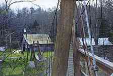 west
end of Townsend is only accessible from the old highway that runs on the
other side of Little River. To get to this road, you have to cross Little
River using the narrow automobile bridge that is off of Hwy. 321 across
from the Creekside Restaurant. Turn right (?) on the old highway and watch
for a sign for the swinging bridge. The bridge is set back off of the road
and parking is available for all of two cars! The other swinging bridge
is on the east side of Townsend and is located near a small wedding chapel.
Unfortunately, the exact route to take to get there escapes me at the moment,
so take this opportunity to explore the roads in Townsend.
west
end of Townsend is only accessible from the old highway that runs on the
other side of Little River. To get to this road, you have to cross Little
River using the narrow automobile bridge that is off of Hwy. 321 across
from the Creekside Restaurant. Turn right (?) on the old highway and watch
for a sign for the swinging bridge. The bridge is set back off of the road
and parking is available for all of two cars! The other swinging bridge
is on the east side of Townsend and is located near a small wedding chapel.
Unfortunately, the exact route to take to get there escapes me at the moment,
so take this opportunity to explore the roads in Townsend.
The Little
River Railroad Museum is located on Hwy 321. This museum shows some
of the rail engines and equipment used by the logging companies when they
were hauling timber out of the Smokies. In fact, Townsend is named after
Colonel Wilson B.Townsend who started and operated the Little River Lumber
Company. The town of Townsend grew up around the saw mill of the Little
River Lumber Company in the early 1900s. Prior to this, the community was
known as Tuckaleechee because it is located in Tuckaleechee Cove.
For more travel and information links on the Smokies,
visit our Smoky Mountains Page.
The
Left Fork:
Little River, Meigs Falls, The Sinks,
Metcalf Bottoms Picnic Area,
Laurel Falls, Sugarlands Visitor Center
|

The
Right Fork:
Cades Cove Picnic Area,
Cades Cove, Horseback Riding,
Cades Cove Campground
|
Need to see a map of the GSMNP?
Check out the
National
Park Service digital maps web site
for maps of most of the National
Parks
Be sure to visit these
other Lotz Family pages:
Copyright
1997 - 2006 by the Lotz Family
Updated 3/8/2006
This page hosted by  Get your own Free Home Page