A Lotz Family Travel
Page
Copyright 1999 - 2006
by the Lotz Family
To the Smokies
from Townsend
Little
River Road - The Left Fork
Little River,
Meigs Falls, The Sinks, Metcalf Bottoms Picnic Area, Laurel Falls, and
Sugarlands Visitor
Center
The left fork at Little River Road takes you to Sugarlands
Visitor Center and the north entrance to the park on Highway 441. This
section of road is much more curving and twisting as it follows the Little
River.  Take your time and drive slowly, not only because the road topology demands
it, but so you can enjoy the spectacular scenery and coursing river. Driving
distance from Townsend to Sugarlands Visitor Center is 34 miles. The road
crosses over the river at several points, so the river is viewable from
the right or left sides of your vehicle as you travel this road. There
are many pull-offs where you can stop and take in the views. Just be careful
as you pull off or onto the road - traffic can be heavy during peak seasons.
Take your time and drive slowly, not only because the road topology demands
it, but so you can enjoy the spectacular scenery and coursing river. Driving
distance from Townsend to Sugarlands Visitor Center is 34 miles. The road
crosses over the river at several points, so the river is viewable from
the right or left sides of your vehicle as you travel this road. There
are many pull-offs where you can stop and take in the views. Just be careful
as you pull off or onto the road - traffic can be heavy during peak seasons.
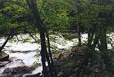 Driving
this road after it rains heavily will reward you with awesome white water
in the normally gently cascading flow of the Little River! It's unbelievable
how quickly the river can turn into a raging torrent of white water.
The noise of the raging water is so loud, it's hard to hold a normal conversation.
Driving
this road after it rains heavily will reward you with awesome white water
in the normally gently cascading flow of the Little River! It's unbelievable
how quickly the river can turn into a raging torrent of white water.
The noise of the raging water is so loud, it's hard to hold a normal conversation.
 We
were amazed how quickly the flow of the stream increased and we now have
great respect for flash flood warnings that are issued during rainstorms
in the Smokies. Of course the kayakers live for the resulting white water
conditions. After a heavy rain they head into the park with kayaks strapped
to the top of their cars. It's interesting to watch them paddle and steer
their kayak around the rocks in the churning waters. Another sight to watch
for are the "dry waterfalls" along the roadside. Normally, no water
flows in these falls but as soon as wet weather moves across the Smokies,
the small falls come alive. Be sure to observe all caution signs
posted at the rivers and streams. The currents and water depths can be
deceiving and several people have drowned while swimming in park waters.
We
were amazed how quickly the flow of the stream increased and we now have
great respect for flash flood warnings that are issued during rainstorms
in the Smokies. Of course the kayakers live for the resulting white water
conditions. After a heavy rain they head into the park with kayaks strapped
to the top of their cars. It's interesting to watch them paddle and steer
their kayak around the rocks in the churning waters. Another sight to watch
for are the "dry waterfalls" along the roadside. Normally, no water
flows in these falls but as soon as wet weather moves across the Smokies,
the small falls come alive. Be sure to observe all caution signs
posted at the rivers and streams. The currents and water depths can be
deceiving and several people have drowned while swimming in park waters.
Be sure to watch for wildflowers on your walks
on the trails. There is such diversity in the park because of the  large
change in elevations, that something is always blooming from late March
through July. The trilliums, flame azaleas, rhododendron, and red bud trees
are spectacular when they are blooming.
large
change in elevations, that something is always blooming from late March
through July. The trilliums, flame azaleas, rhododendron, and red bud trees
are spectacular when they are blooming.
 The
first outstanding feature along Little River Road is Meigs Falls
on the right side of the road. It's easy to drive by and not notice the
falls because it is set back off of the roadway about 300 feet. So watch
for the pull-off. Meigs Falls is quite spectacular in the fall and wet
seasons. Words just can't describe the picture painted by a waterfall nestled
in the woods adorned with their brilliant fall colors. Stop for a while,
relax, and soak up the view.
The
first outstanding feature along Little River Road is Meigs Falls
on the right side of the road. It's easy to drive by and not notice the
falls because it is set back off of the roadway about 300 feet. So watch
for the pull-off. Meigs Falls is quite spectacular in the fall and wet
seasons. Words just can't describe the picture painted by a waterfall nestled
in the woods adorned with their brilliant fall colors. Stop for a while,
relax, and soak up the view.
One of our favorite stops along this road is The
Sinks. The parking area on the right is small, so it's best to stop  here
in the early morning in the peak seasons. Here the river makes a drastic
change in course and rushes over some large exposed rocks in the river
bed. The sounds of the water and wilderness views combine to produce a
fantastic experience for one's senses. One story has it that The Sinks
were formed when a logging crew tried to break up a huge log jam on the
river when logging was taking place in the park. Too much dynamite was
used and The Sinks was the result. Then again, maybe it's the work of Mother
Nature!
here
in the early morning in the peak seasons. Here the river makes a drastic
change in course and rushes over some large exposed rocks in the river
bed. The sounds of the water and wilderness views combine to produce a
fantastic experience for one's senses. One story has it that The Sinks
were formed when a logging crew tried to break up a huge log jam on the
river when logging was taking place in the park. Too much dynamite was
used and The Sinks was the result. Then again, maybe it's the work of Mother
Nature!
The next item of interest is Metcalf Bottoms
picnic area and is named for the family that farmed here. It's so relaxing
to have lunch next to the rushing waters of the Little River in the shade
of ancient trees. There is a bridge that crosses the river and on the other
side is a trail that leads to Little Greenbrier School and cemetery. Check
the park's publications for more information on this trail. This trail
is on our to-do list of hikes in the park.
On down the road is Elkmont Campground and
Nature Trail. Unfortunately, we have only briefly driven a short distance
into this area and still want to explore it in more detail. Again, refer
to the park's publications for more information on this area.
 The
access to the Laurel Falls trail is the next major attraction on
the Little River Road. It's hard to miss since there are parking areas
on both sides of the road and both are usually filled with vehicles. Drive
slowly and cautiously through this area, it's almost always congested with
cars and people. The paved two and one half mile (round trip) trail leads
to a cascading waterfall with a wooden walkway crossing the stream at the
base of the falls. The trail meanders through a quiet forest and during
our walk here, we spotted several deer along the trail. Do not climb to
the top of the falls or walk on the rocks at the base. The slick, wet surfaces
can quickly lead to falls (no pun intended), and cause serious injury or
even death.
The
access to the Laurel Falls trail is the next major attraction on
the Little River Road. It's hard to miss since there are parking areas
on both sides of the road and both are usually filled with vehicles. Drive
slowly and cautiously through this area, it's almost always congested with
cars and people. The paved two and one half mile (round trip) trail leads
to a cascading waterfall with a wooden walkway crossing the stream at the
base of the falls. The trail meanders through a quiet forest and during
our walk here, we spotted several deer along the trail. Do not climb to
the top of the falls or walk on the rocks at the base. The slick, wet surfaces
can quickly lead to falls (no pun intended), and cause serious injury or
even death.
Sugarlands Visitor Center is the next major
stopping point. Information and publications on the park's history,  flora,
fauna, and trails and be purchased at the Sugarlands Visitor Center. For
additional information on the park, purchase a copy of the "Smokies Guide"
at any visitor center. It costs 25 cents and is published four times a
year by the Great Smoky Mountains Natural History Association. All proceeds
benefit the park. The latest weather, road, and trail conditions are posted,
also. Rest rooms are located nearby in a separate building. A short loop
nature trail is just off to the side of the rest rooms and provides easy
viewing of some native wildflowers. Be sure to check the flower beds near
the visitor center as they are planted with native wildflowers and shrubs.
From the Sugarlands Visitor center you have access to Hwy. 441 with Gatlinburg
and Pigeon Forge to the north and Newfound Gap Road that runs south,
through the park to Cherokee, North Carolina, where the parks boundary
ends.
flora,
fauna, and trails and be purchased at the Sugarlands Visitor Center. For
additional information on the park, purchase a copy of the "Smokies Guide"
at any visitor center. It costs 25 cents and is published four times a
year by the Great Smoky Mountains Natural History Association. All proceeds
benefit the park. The latest weather, road, and trail conditions are posted,
also. Rest rooms are located nearby in a separate building. A short loop
nature trail is just off to the side of the rest rooms and provides easy
viewing of some native wildflowers. Be sure to check the flower beds near
the visitor center as they are planted with native wildflowers and shrubs.
From the Sugarlands Visitor center you have access to Hwy. 441 with Gatlinburg
and Pigeon Forge to the north and Newfound Gap Road that runs south,
through the park to Cherokee, North Carolina, where the parks boundary
ends.
 A
lovely waterfall is located near the visitors center. Cataract Falls
is an easy 0.1 mile walk on a reasonably level dirt trail. We have never
run into any crowds at these falls, given its close proximity to the visitor
center. The woodlands are cool and quiet. To access the trail from the
visitor center, walk past the rest rooms and past the nature trail. At
the fire hydrant , keep to the left and walk through the park employee
parking lot. To the right will be the Park Headquarters. Continue through
the parking lot to a road that crosses a bridge. The trail to Cataract
Falls begins on the other side of the bridge. The first time we did this
we could not find the trail head and had to ask a ranger for directions.
Now we can easily find our way to the falls and have visited Cataract Falls
during spring, summer, and fall. We have read that the falls can be spectacular
in the winter when portions of it freezes over and the surroundings become
encrusted in shimmering ice crystals. As with all waterfalls in the park,
do not climb to the top of the falls or walk on the rocks at the base.
The slick, wet surfaces can quickly lead to falls (no pun intended), and
cause serious injury or even death.
A
lovely waterfall is located near the visitors center. Cataract Falls
is an easy 0.1 mile walk on a reasonably level dirt trail. We have never
run into any crowds at these falls, given its close proximity to the visitor
center. The woodlands are cool and quiet. To access the trail from the
visitor center, walk past the rest rooms and past the nature trail. At
the fire hydrant , keep to the left and walk through the park employee
parking lot. To the right will be the Park Headquarters. Continue through
the parking lot to a road that crosses a bridge. The trail to Cataract
Falls begins on the other side of the bridge. The first time we did this
we could not find the trail head and had to ask a ranger for directions.
Now we can easily find our way to the falls and have visited Cataract Falls
during spring, summer, and fall. We have read that the falls can be spectacular
in the winter when portions of it freezes over and the surroundings become
encrusted in shimmering ice crystals. As with all waterfalls in the park,
do not climb to the top of the falls or walk on the rocks at the base.
The slick, wet surfaces can quickly lead to falls (no pun intended), and
cause serious injury or even death.
You've probably already noticed that there is no
entrance fee for the GSMNP. This is due to a clause in the Park's enabling
legislation. Other parks such as Grand Canyon and Yellowstone can charge
entrance fees of $20 per vehicle and earn millions of dollars in supplemental
funding as a result. Please consider making purchases at the Visitors Centers
where proceeds go toward funding worthwhile projects in the Park. Additional
financial help is provided by the Great
Smoky Mountains Association and the Friends
of the Smokies organizations. Please consider joining these organizations
in their effort to help the Park. There are also donation boxes along side
some of the roads in the park.
For more travel links on the Smokies, visit our Smoky
Mountains Page.
For a listing of publications on the Smokies that
we have found to be helpful, check out the Lotz
Travel Bookstore or use the box below to search Amazon.com for your interests.
The
Right Fork:
Cades Cove Picnic Area,
Cades Cove, Horseback Riding,
Cades Cove Campground |

|
Want to see a map of the GSMNP?
Check out the
National
Park Service digital maps web site
for maps of most of the National
Parks
Be sure to visit these
other Lotz Family pages:
All
photographs copyright 1997 - 2006 by the Lotz Family
Updated 1/22/06
This page hosted by  Get your own Free Home Page