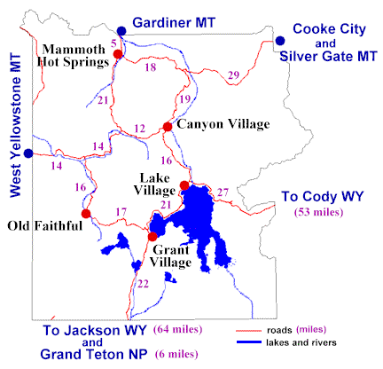
Yellowstone Roads
| Milage Chart | Old Faithful | Grant Village | Lake Hotel | Canyon | Mammoth | Roosevelt | Cody | Gardiner | Jackson | West Yellowstone |
| Old Faithful | 19 | 38 | 42 | 51 | 61 | 118 | 56 | 103 | 30 | |
| Grant Village | 19 | 24 | 40 | 73 | 59 | 103 | 75 | 84 | 49 | |
| Lake Hotel | 38 | 24 | 17 | 49 | 36 | 81 | 55 | 108 | 57 | |
| Canyon | 42 | 40 | 17 | 33 | 19 | 96 | 38 | 124 | 40 | |
| Mammoth | 51 | 73 | 49 | 33 | 18 | 129 | 5 | 157 | 49 | |
| Roosevelt | 61 | 59 | 36 | 19 | 18 | 115 | 23 | 143 | 59 | |
| Cody | 118 | 103 | 81 | 96 | 129 | 115 | 134 | 187 | 136 | |
| Gardiner | 56 | 75 | 55 | 38 | 5 | 23 | 134 | 159 | 54 | |
| Jackson | 103 | 84 | 108 | 124 | 157 | 143 | 187 | 159 | 133 | |
| West Yell. | 30 | 49 | 57 | 40 | 49 | 59 | 136 | 54 | 133 |
In the early days of the park the road system was designed in a figure eight configuration that provided access to most of the major sites. The road was first designed as a wagon road and from its current condition you may think that it still is. The roads still, basically, follow the original wagon road but improvements have been and still are being made.
The entire loop is 142 miles long. The upper loop of the figure eight is 70 miles and the lower loop is 96 miles.
 The maximum speed limit is
45 mph but in summer you will be lucky to average 25 mph because
of traffic, wildlife and road conditions.
The maximum speed limit is
45 mph but in summer you will be lucky to average 25 mph because
of traffic, wildlife and road conditions.
The roads in the park are bad. Most of the roads are narrow, winding and rough. Potholes are common. The Park Service is currently bring the roads up to modern standards. Thus, road construction and closures are scheduled for the upcoming years. When you enter the park you will be given information about the current road construction. Read this information to determine if it will cause you any hardships.
2000 Road Construction Closure Schedule.
For the most part the roads have no shoulders. This coupled with people stopping in the middle of the road to see wildlife can make for slow and aggravating travel. Expect this to happen and prepare yourself mentally so you don't have a heart attack.
Take pity on the people behind you. If you stop try to pull off the road as far as possible.
Avoid the worst traffic by arranging your sight seeing so that you do most of your driving in the morning and late afternoon when there is less traffic. On the plus side, this is also the best time and method to see wildlife.
Only the road from Gardiner MT through Mammoth and onto Cooke City MT is open to wheeled vehicles all year. The park service tries to have the other roads open on the following schedule:
Early-mid-April:
- Mammoth to Norris
Mid-April:
- West entrance to Madison, Madison to Old Faithful, Madison to Norris, Norris to Canyon, Canyon to Mud Volcano
Early May:
- Old Faithful to West Thumb, Mud Volcano to Lake, Lake to East Entrance, Lake to South Entrance
Early June:
- Tower to Canyon
The roads are usually closed the first Sunday of November.
2000 Road Opening and Closing Schedule.
Of course, these dates are subject to weather.
To get a recorded message of current road conditions and construction, call the park headquarters at (307)-344-7381.
On an up note: Most of the side roads (usually one way) are worth the drive. They usually take a little longer than the main road but also have some unique or interesting sight to see along the way.
In the winter, once there is enough snow (about December-March), the roads are opened to tracked vehicles (snow mobiles and snow coaches).
[ Yellowstone Travel Guide Index ] [ Transportation and the Park Roads ]
![]() Comments
and Questions are Welcome.
Comments
and Questions are Welcome.
This site is hosted by Geocities. Get your own Free Homepage.
The picture, that is shown on this page, of bison in the road (most likely in Hayden Valley) is from "BAY AREA BACKROADS".