Passport stamp for Bahamas
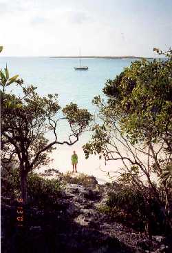
 The next morning,
Sunday the 25th of February, we put the dinghy in the water so I could
check in with customs. After a wet dinghy ride through the chop stirred
up by 25-knot winds, and a hot walk up the road to the customs office (closed)
I retraced my steps, and we resigned ourselves to yet another night in
the rolly anchorage. On Monday I repeated the journey to customs,
only to find out that they wanted Cathy present to sign an immigration
form. Back in the dinghy I went for yet another trip, and by noon
we were officially cleared in to the Bahamas. Too late to move on
to another anchorage, we spent the afternoon ashore trying to avoid the
movement of the boat. Cathy walked the beach, while I read a book
under the partial shade of some low bushes.
The next morning,
Sunday the 25th of February, we put the dinghy in the water so I could
check in with customs. After a wet dinghy ride through the chop stirred
up by 25-knot winds, and a hot walk up the road to the customs office (closed)
I retraced my steps, and we resigned ourselves to yet another night in
the rolly anchorage. On Monday I repeated the journey to customs,
only to find out that they wanted Cathy present to sign an immigration
form. Back in the dinghy I went for yet another trip, and by noon
we were officially cleared in to the Bahamas. Too late to move on
to another anchorage, we spent the afternoon ashore trying to avoid the
movement of the boat. Cathy walked the beach, while I read a book
under the partial shade of some low bushes.
On Tuesday we moved to the western end of Mayaguana Island and anchored in an open roadstead that would give us an easy coral-free departure early the following morning. As we expected, the roll in this unprotected spot made us more than ready to leave by 0530 the following morning. After an uneventful eight hours motoring westward, we arrived at Attwood Harbour near Acklin's Island. Cartographically speaking, Attwood Harbour is nearly the mirror image of the one in Abraham's Bay, Mayaguana. This time the island extends to the south and east, with a cape to the northeast and a reef to the north of the anchorage, deceptively hinting at protection from easterly winds. To our distress, we found the harbor almost as rolly as Mayaguana. Still, we stayed for two nights, walking the curving sandy beach, and swimming with the six foot barracuda (the largest we have ever seen) who seems to be a permanent resident of the harbor.
Little Harbour, Bahamas
 On Friday the 2nd
of March, we motored another 65 miles westward and entered Little Harbour
on Long Island. We had finally found a calm spot to anchor, and we
slept long and deep sleep that night. Incongruously, Little Harbour
faces towards the east, the direction of the prevailing winds, yet except
for a few hours near high tide, no roll entered the harbor. The first
day we had the whole anchorage to ourselves, then boats started arriving
to take shelter from an approaching cold front and the strong westerly
winds accompanying it. In the end, there were five boats, including
Sovereign, who sought shelter from the weather. We wound up founding
the "Little Harbour Yacht Club." Afternoons were passed in friendly
games of bocce (a game best described as a mix of horseshoes, shuffleboard,
and bowling) on the beach. Every evening we had cocktails on a different
boat, discussing the prognosis for the weather, anchorages, grocery stores,
and all the other things cruisers normally talk about when they get together.
At 35 feet, Sovereign was a good five feet shorter than the next smallest
boat of the group, but we still managed to fit eleven people aboard when
it was our turn to host cocktails! It was serendipity that the strong
weather lasted exactly long enough for each boat to host an evening's entertainment.
On Friday the 2nd
of March, we motored another 65 miles westward and entered Little Harbour
on Long Island. We had finally found a calm spot to anchor, and we
slept long and deep sleep that night. Incongruously, Little Harbour
faces towards the east, the direction of the prevailing winds, yet except
for a few hours near high tide, no roll entered the harbor. The first
day we had the whole anchorage to ourselves, then boats started arriving
to take shelter from an approaching cold front and the strong westerly
winds accompanying it. In the end, there were five boats, including
Sovereign, who sought shelter from the weather. We wound up founding
the "Little Harbour Yacht Club." Afternoons were passed in friendly
games of bocce (a game best described as a mix of horseshoes, shuffleboard,
and bowling) on the beach. Every evening we had cocktails on a different
boat, discussing the prognosis for the weather, anchorages, grocery stores,
and all the other things cruisers normally talk about when they get together.
At 35 feet, Sovereign was a good five feet shorter than the next smallest
boat of the group, but we still managed to fit eleven people aboard when
it was our turn to host cocktails! It was serendipity that the strong
weather lasted exactly long enough for each boat to host an evening's entertainment.
Finally, on Friday, 9 March, we left Little Harbour and motored north along the coast of Long Island. Shortly after noon, we crossed 23°26.3'N latitude, the Tropic of Cancer, and we officially left the tropics. That night we anchored at the roadstead on the northern tip of Long Island, where we experienced our second worst night at anchor ever. We lay in our sea berths, trying not to listen to all the small objects in the cabin clattering and rattling like they do on a sea passage. We spent a restless night, and were once again glad to leave the next morning.
It took one more day of motoring to reach Georgetown, on Great Exuma Island. When we finally arrived, we stared in awe at the harbor. We had arrived at the start of the weeklong Cruising Regatta. Boats had been converging on this area for weeks, and we found well over 400 boats spread around the several anchorages in the vicinity of Georgetown! Since leaving the U.S. Virgin Islands, we had become used to being the only boat in a harbor. Until now, the "Little Harbour Yacht Club," five whole boats, was the biggest crowd we had seen in six weeks. This many boats just overwhelmed us. The VHF radio was alive with activity, more than in Ft. Lauderdale, Annapolis, Newport, or any other port we had visited. In fact, there was so much radio traffic that we wound up just turning the radio off, something we almost never do.
A boat washed ashore on Stocking Island
 Georgetown itself
is a pleasant Bahamian town, big enough to sport a bank and two grocery
stores, but small enough to walk everywhere. It is situated around
a small lake, connected to the main harbor by a narrow cut just large enough
to take a dinghy through. Our big priorities in Georgetown were to
pick up a few more provisions, fill the fuel tanks, and most importantly
to locate a restaurant for us to celebrate Cathy's birthday. In three
days we managed to celebrate Cathy's birthday, get our "chores" done, and
still have time for some nice beach-combing on Stocking Island, and to
have dinner aboard the boat of friends from Fernandina Beach.
Georgetown itself
is a pleasant Bahamian town, big enough to sport a bank and two grocery
stores, but small enough to walk everywhere. It is situated around
a small lake, connected to the main harbor by a narrow cut just large enough
to take a dinghy through. Our big priorities in Georgetown were to
pick up a few more provisions, fill the fuel tanks, and most importantly
to locate a restaurant for us to celebrate Cathy's birthday. In three
days we managed to celebrate Cathy's birthday, get our "chores" done, and
still have time for some nice beach-combing on Stocking Island, and to
have dinner aboard the boat of friends from Fernandina Beach.
Rat Cay, Exumas
 We left Georgetown
on 13 March, and began hopping north up the chain of the Exumas Islands.
The Exumas provide the type of cruising we love: lots of islands
close together, with plenty of deserted (or at least uncrowded) anchorages
to choose from. These islands stretch in a line from northwest to
southeast for a distance of about 100 miles. To the east of the chain
is Exuma Sound, a nice deep body of water with great blue-water sailing.
To the west is the Great Bahama Bank, an area of shallow water offering
smooth-water sailing and gunkholing. Reading the cruising guide,
nearly every place along the way was some sort of pirate's hideout in the
17th and 18th centuries.
We left Georgetown
on 13 March, and began hopping north up the chain of the Exumas Islands.
The Exumas provide the type of cruising we love: lots of islands
close together, with plenty of deserted (or at least uncrowded) anchorages
to choose from. These islands stretch in a line from northwest to
southeast for a distance of about 100 miles. To the east of the chain
is Exuma Sound, a nice deep body of water with great blue-water sailing.
To the west is the Great Bahama Bank, an area of shallow water offering
smooth-water sailing and gunkholing. Reading the cruising guide,
nearly every place along the way was some sort of pirate's hideout in the
17th and 18th centuries.
On Wednesday, 14 March, we entered Farmer's Cay Cut on our way to Little Farmer's Cay. The current was churning, bubbling, and swirling, making whirlpools and small current boils as it ripped through the cut. We had the engine running at high RPMs to fight the current, and Cathy struggled to hold the tiller steady in the turbulent water. As I stood at the bow to direct Cathy around any coral heads, an osprey flew straight across our path just off our bow. It was a rare juxtaposition of the strength and grace of nature that we are occasionally graced to observe.
Snorkeling in Thunderball Cave
 Two days later
we were treated to another display of nature's beauty as we went snorkeling
at Thunderball Cave. Thunderball is where the underwater scenes of
the James Bond movie of that name, and the movie "Splash" were filmed.
From the outside, Thunderball looks like any other small cay, with brown
limestone and low green tropical foliage covering its surface. However,
as we snorkeled around the edges of the cay and looked under the surface
of the water, we could see large holes where the dark rock gave way to
the turquoise of sunlit water. A short swim under water leads you
to a cavern, perhaps 50 feet across and 30 feet high, with holes in the
top that let in the sunlight. At every turn other passages lead back
outside. A big and unafraid school of yellow, gray, and black- striped
sergeant-major fish stands patrol at one of the entrances, waiting for
free handouts from swimmers. Inside, huge blue angelfish, green and
blue parrotfish, and other varieties of reef fish swim around in the big
bowl of the cave with us. In an uncharacteristic fit of tourism,
we take almost a whole roll of film of underwater shots that we know won't
come out.
Two days later
we were treated to another display of nature's beauty as we went snorkeling
at Thunderball Cave. Thunderball is where the underwater scenes of
the James Bond movie of that name, and the movie "Splash" were filmed.
From the outside, Thunderball looks like any other small cay, with brown
limestone and low green tropical foliage covering its surface. However,
as we snorkeled around the edges of the cay and looked under the surface
of the water, we could see large holes where the dark rock gave way to
the turquoise of sunlit water. A short swim under water leads you
to a cavern, perhaps 50 feet across and 30 feet high, with holes in the
top that let in the sunlight. At every turn other passages lead back
outside. A big and unafraid school of yellow, gray, and black- striped
sergeant-major fish stands patrol at one of the entrances, waiting for
free handouts from swimmers. Inside, huge blue angelfish, green and
blue parrotfish, and other varieties of reef fish swim around in the big
bowl of the cave with us. In an uncharacteristic fit of tourism,
we take almost a whole roll of film of underwater shots that we know won't
come out.
Anglefish in Thunderball Cave
 The following day
we moved on to Warderick Wells, the headquarters of the Exuma Land and
Sea Park. To save the expense of a mooring, we anchor at the southern
anchorage, where it is a 2 ½ mile dinghy ride to the park headquarters.
Where we are anchored, there is a short trail that leads to "Pirates Lair",
a hidden clearing in the jungle with a natural well (now brackish) where,
our cruising guide tells us, pirates used to hang out and do whatever pirates
did when they weren't pirating. We hiked some of the trails on the
north side of the island, including the one up Boo Boo Hill, where we placed
a plaque reading "Sovereign, Jim + Cathy, March 18, 2001" alongside similar
signs from other vessels which have passed this way.
The following day
we moved on to Warderick Wells, the headquarters of the Exuma Land and
Sea Park. To save the expense of a mooring, we anchor at the southern
anchorage, where it is a 2 ½ mile dinghy ride to the park headquarters.
Where we are anchored, there is a short trail that leads to "Pirates Lair",
a hidden clearing in the jungle with a natural well (now brackish) where,
our cruising guide tells us, pirates used to hang out and do whatever pirates
did when they weren't pirating. We hiked some of the trails on the
north side of the island, including the one up Boo Boo Hill, where we placed
a plaque reading "Sovereign, Jim + Cathy, March 18, 2001" alongside similar
signs from other vessels which have passed this way.
Signs atop Boo Boo Hill
 For the last few
days we have been sitting here at Warderick Wells, waiting for the passage
of a strong cold front so that we can move on again. We will be sad
to leave the Exumas, certainly for us the highlight of this country's islands.
After a rough start, the islands of the Bahamas have gotten better and
better. Maybe that's just what the slogan "It's better in the Bahamas"
really means.
For the last few
days we have been sitting here at Warderick Wells, waiting for the passage
of a strong cold front so that we can move on again. We will be sad
to leave the Exumas, certainly for us the highlight of this country's islands.
After a rough start, the islands of the Bahamas have gotten better and
better. Maybe that's just what the slogan "It's better in the Bahamas"
really means.
Smooth sailing,
Jim and Cathy