CruiseNews 39
Date: 26 February, 2001
Port of Call: Abraham's Bay, Mayaguana, Bahamas
Subject: The Turks and Caicos Two-Step
Passport stamp from Turks and Caicos
 Since arriving
in the Turks and Caicos at the beginning of February, Sovereign has been
doing a two-step dance across the islands: we spend a few days in
one anchorage, move on to one harbor, then another, only to backstep the
following day. It is the special geography of these islands that
dictates this unusual method of travelling across them. The Turks
and Caicos are a string of a half-dozen low islands, with numerous scattered
cays (pronounced "keys"), which span about 85 miles of the southwest North
Atlantic. They are geographically part of the Bahamas Platform, but
politically they are a British Crown Colony and are unrelated to the Bahamas.
The islands jut abruptly out of the deep Atlantic, rising several miles
straight from the bottom of the ocean, only to peek (or peak, if you prefer)
a few dozen feet above the sea. The islands are generally rimmed
by coral reefs with turquoise waters, then outside the reefs the sea turns
deep blue as the depth plummets suddenly. The eastern Turks group
is surrounded on all sides by deep water, while the western Caicos have
an extensive shallow bank on their southern side that extends some 40 miles
before dropping steeply away. The shallow coral, requiring a high
sun angle for good eyeball navigation, and the long distances between island
groups, necessitating long passages between anchorages are what set these
islands apart from those we have previously visited.
Since arriving
in the Turks and Caicos at the beginning of February, Sovereign has been
doing a two-step dance across the islands: we spend a few days in
one anchorage, move on to one harbor, then another, only to backstep the
following day. It is the special geography of these islands that
dictates this unusual method of travelling across them. The Turks
and Caicos are a string of a half-dozen low islands, with numerous scattered
cays (pronounced "keys"), which span about 85 miles of the southwest North
Atlantic. They are geographically part of the Bahamas Platform, but
politically they are a British Crown Colony and are unrelated to the Bahamas.
The islands jut abruptly out of the deep Atlantic, rising several miles
straight from the bottom of the ocean, only to peek (or peak, if you prefer)
a few dozen feet above the sea. The islands are generally rimmed
by coral reefs with turquoise waters, then outside the reefs the sea turns
deep blue as the depth plummets suddenly. The eastern Turks group
is surrounded on all sides by deep water, while the western Caicos have
an extensive shallow bank on their southern side that extends some 40 miles
before dropping steeply away. The shallow coral, requiring a high
sun angle for good eyeball navigation, and the long distances between island
groups, necessitating long passages between anchorages are what set these
islands apart from those we have previously visited.
When we first arrived on 2 February after our passage from the Virgin
Islands, we dropped the anchor in an easily accessible spot off of Cockburn
Town, Grand Turk, which didn't require any eyeball navigation through coral.
The next day, in order to clear in with customs, we moved down to the south
end of Grand Turk and anchored off the commercial dock. After checking
in, we raised anchor and motored back to the town, and with the sun high
overhead providing good visibility of the coral beneath the water, we anchored
inside the reef near Cockburn Town. We spent a few days anchored
off Cockburn Town, where we repaired the watermaker and visited the excellent
museum ashore. The museum featured exhibits from the earliest excavated
European shipwreck in the Americas, circa 1515. It was filled with
the usual cannons, guns, and metal artifacts, as well as photographs of
the ballast pile and excavation process, plus information on the natural
history of the area. We left the museum both entertained and informed.
On 6 February, we sailed the 23 miles across the Turks Island Passage
to South Caicos. We passed through the cut at South Caicos, where
incongruously the beacons at the harbor entrance are green to starboard
and red to port, the only place I know of in the Americas where this is
the case. We turned out of the channel and tucked in behind Long
Cay, where we found our first truly calm anchorage in over a week.
Unfortunately, this was not to last, as during the night the wind began
building, and by the next day we had winds of 20 to 25 knots. While
protected from the sea swells, a large wind-driven chop made the anchorage
less than perfect. We spent the next nine days socked in as we waited
for conditions to calm down.
The rocky outer shore of Long Cay, South Caicos
 A few times, despite
the windy weather, we ventured out in the dinghy. We went ashore
and saw the town, a collection of roughly a hundred small wooden houses
and a few shops. We explored Long Cay and took the obligatory photo
of Sovereign at anchor. We walked the deserted beach on the eastern
side of South Caicos. One day we snorkeled at the harbor entrance
and had the thrill of seeing numerous spotted rays engaged in a graceful
underwater ballet, spiraling through the water, their long tails streaming
behind them. We also had the excitement of seeing a pair of sharks
cruising the reef's edge and watching us ominously through their beady
eyes.
A few times, despite
the windy weather, we ventured out in the dinghy. We went ashore
and saw the town, a collection of roughly a hundred small wooden houses
and a few shops. We explored Long Cay and took the obligatory photo
of Sovereign at anchor. We walked the deserted beach on the eastern
side of South Caicos. One day we snorkeled at the harbor entrance
and had the thrill of seeing numerous spotted rays engaged in a graceful
underwater ballet, spiraling through the water, their long tails streaming
behind them. We also had the excitement of seeing a pair of sharks
cruising the reef's edge and watching us ominously through their beady
eyes.
Trying out the rat lines
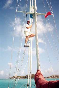 Most of the time
we stayed aboard Sovereign, reading and doing odd jobs. Several times each
day a voice would come on the radio saying (we think) "Singer Sam, now
go one-three" (though he could have easily have been saying "sing a hymn,"
or pretty much any three syllable phrase starting with "sing" and ending
with the letter M). We switched the VHF radio to channel 13, and
listened to a lone voice belting out church hymns with plenty of feeling,
though not much adherence to any particular key. When we weren't
being entertained with hymns, we worked on improving our ratlines so we
could climb up the mast to the first set of spreaders. We also read
a lot, putting a big dent in our stock of "trading books," cheap paperbacks
that we swap with other cruisers. We re-watched the few movies we
had aboard. I even fired up Visual Basic on the computer and wrote
a program to help with my ham radio operations. I'll admit it; after
nine days with no place to go, we were getting stir crazy.
Most of the time
we stayed aboard Sovereign, reading and doing odd jobs. Several times each
day a voice would come on the radio saying (we think) "Singer Sam, now
go one-three" (though he could have easily have been saying "sing a hymn,"
or pretty much any three syllable phrase starting with "sing" and ending
with the letter M). We switched the VHF radio to channel 13, and
listened to a lone voice belting out church hymns with plenty of feeling,
though not much adherence to any particular key. When we weren't
being entertained with hymns, we worked on improving our ratlines so we
could climb up the mast to the first set of spreaders. We also read
a lot, putting a big dent in our stock of "trading books," cheap paperbacks
that we swap with other cruisers. We re-watched the few movies we
had aboard. I even fired up Visual Basic on the computer and wrote
a program to help with my ham radio operations. I'll admit it; after
nine days with no place to go, we were getting stir crazy.
Finally, on 16 February, the winds eased down to 15-20 knots, and we
decided to try and cross the Caicos Bank. We raised anchor about
0730 and motored out the channel and around Long Cay. At the south
end of Long Cay, we entered the Banks. I climbed up the ratlines
and scouted the way as Cathy steered. After getting through the first
few miles, the underwater obstructions were less numerous, so I climbed
down to deck level to look out. Throughout the day as we motored
across the banks, we swapped duty standing watch for coral heads, one of
us on the bow, the other at the helm steering. It is a little disconcerting
after being in deep water for so long to have to think of 10 feet of water
as "deep". In these islands, as long as you're not aground, you're
in "deep" water. As we motored along, we watched the sandy bottom
roll by beneath us, and admired the clouds above, tinted a faint mint-green
from the reflection of the color of the banks. We anchored that night
in Sapodilla Bay, on the south side of Providenciales (called Provo by
the locals), thoroughly exhausted after a strenuous day of piloting through
the coral. Even though the boat rolled uncomfortably at anchor in
the chop coming around the point, we both dropped into bed early that night.
The next day, we moved around to the northern shore of Provo.
We raised anchor and motored across the banks towards Sandbore Channel.
In the middle of the channel is a large area of agitated sandy water which
makes it impossible to see the bottom. We skirted the sandbore and
sailed out into the blue abyss, watching the depthsounder readings drop
from 12 feet to off-soundings in less than a minute. We sailed around
the northwest corner of Provo in bright, sparkling conditions. We
arrived off the entrance of Sellars Cut anticipating some difficult coral
navigation. I climbed up the ratlines to the spreaders as Cathy steered.
Fortunately, we found the entrance much easier than we anticipated because
the marina at Turtle Cove had placed a series of buoys to mark the best
water. We followed these in, and anchored just outside the marina
entrance. Unfortunately, the reefs there were not quite dense enough
or tall enough to completely block the ocean swell, and we spent yet another
night sleeping in our sea berths, rolling at anchor.
The following morning we waited for the sun to climb high enough to
again provide good underwater visibility and we motored back out through
Sellars Cut and then headed east the few miles towards the next opening
in the reef, called Leeward Cut. As we motored along, a large squall
approached from the east and shut out the sunlight. We slowed the
boat to the slowest speed we could make and still maintain steerageway,
and hoped for the squall to pass before the sun got too low for good eyeball
piloting. Finally, when a brief opening appeared in the clouds, we
made a break. With Cathy at the helm, and me up the ratlines, we
steered for the narrow gap in the reefs. The cruising guide's sketch
chart showed two buoys at critical points at the entrance, and suggested
that a big marina under construction when the guide was written would probably
dredge the entrance to cater to mega-yachts. We expected a nice deep
channel marked by buoys like the one we had just left. However, as
we piloted through the reefs, we found nothing of the sort and found that
to the contrary things seem to have silted in, making passage even more
difficult than we expected. After running aground once and backing
off, we finally made our way into deeper water inside. We anchored
in the shelter of three islands, and enjoyed flat water for the first time
in over a week. We were the only boat visible, except for the masts
of some day-charter catamarans on the other side of one of the small cays.
Our first priority after getting a good night's sleep was to try and
buy some groceries. We hadn't been to a grocery store in three weeks,
and our supply of fresh goods was running low. We dinghied over to
the "marina", a concrete wall along the side of a creek, which supported
a few local outboard-powered boats but certainly no mega-yachts, and checked
on the availability of a grocery store. We were told it was a $15
taxi ride from the marina, about 8 miles away. We decided to hitchhike
instead, but before we even made it off the dock, we were offered a ride
by the owner of a local dive-boat. He drove us all the way to the
grocery store and dropped us at the front door. We were thrilled!
We bought our groceries and managed to catch a bus back to the marina.
Iguana, Little Water Cay
 We spent the next
three days catching up on sleep and exploring by dinghy. One of the
islands we had anchored by was Little Water Cay, which is a wildlife sanctuary.
We took the dinghy ashore and walked to the start of a boardwalk that ran
inland from the beach. When we reached the boardwalk we were met
by several iguanas, perhaps two feet long including their tails, which
seemed to have no fear of humans. We walked along the boardwalk,
shooing away increasingly larger iguanas and reading signs about the iguanas
and the local flora of sea grapes and silver palms. By the time we
had finished the loop of the boardwalk, several boats laden with tourists
had arrived and they followed a tour guide along the boardwalk. I
hitched around for another go while Cathy, who had had quite enough of
iguanas, walked the beach. I found that the reason the iguanas had
so little fear of us was because the tour guides constantly tossed them
red grapes, which the iguanas devoured instantly. The guide said
the iguanas were harmless, unless perhaps you had painted your toenails
red and they thought your toes were grapes!
We spent the next
three days catching up on sleep and exploring by dinghy. One of the
islands we had anchored by was Little Water Cay, which is a wildlife sanctuary.
We took the dinghy ashore and walked to the start of a boardwalk that ran
inland from the beach. When we reached the boardwalk we were met
by several iguanas, perhaps two feet long including their tails, which
seemed to have no fear of humans. We walked along the boardwalk,
shooing away increasingly larger iguanas and reading signs about the iguanas
and the local flora of sea grapes and silver palms. By the time we
had finished the loop of the boardwalk, several boats laden with tourists
had arrived and they followed a tour guide along the boardwalk. I
hitched around for another go while Cathy, who had had quite enough of
iguanas, walked the beach. I found that the reason the iguanas had
so little fear of us was because the tour guides constantly tossed them
red grapes, which the iguanas devoured instantly. The guide said
the iguanas were harmless, unless perhaps you had painted your toenails
red and they thought your toes were grapes!
A few days later we went to the north side of Water Cay and spent the
day walking along the beach and snorkeling the offshore reefs. The
reefs had nice healthy coral--staghorn, elkhorn, brain, and fan--as well
as many plenty of small reef fish like parrotfish, blue tang, grouper,
and wrasse. It was the best snorkeling we had seen since leaving
the Tobago Cays in December, and we were glad to find another place with
healthy reefs.
We couldn't leave our anchorage until the time of high tide coincided
with a reasonably high sun angle, so we wound up spending five nights in
this snug little harbor. We were occasionally passed by small skiffs
chasing bonefish on the flats, or a day-charter catamaran with a load of
passengers, but otherwise we had everything blissfully to ourselves.
Finally on 23 February we raised the anchor, and with me directing from
the first set of spreaders, we were able to make our way back out the tricky
and shallow entrance to the relative safety of the open ocean. We
two-stepped back to Sellars Cut, which this time seemed like a breeze compared
to the difficulty of navigating Leeward Cut, and entered Turtle Cove Marina
to take on fuel and clear out with customs. After those tasks were
done, we exited the marina, dropped anchor again, ate lunch and stowed
the dinghy on deck. Then we exited Sellars Cut once more, and retraced
our previous track back around Northwest Point, anchoring at Atlantis Beach
on the western coast of Provo.
Off the shore of Atlantis Beach there were no reefs to cause problems
for our planned early morning departure. On shore was a beautiful
white sandy beach and, just a hundred yards away from our boat, were the
remains of some grass-thatched huts. According to our cruising guide,
the grass huts were formerly the set of a French game show in which contestants
won points on shore, which were later traded for breaths of air in the
under-water treasure hunt portion of the show! We pondered the complexities
of the unusual game show as we watched the sun set behind us over an unbroken
horizon.
The next morning, we were underway by 0530--well before sunrise, but
with just enough gray light on the eastern horizon that we could see things
on deck without using lights. We motored clear of shore, then raised
the triple-reefed mainsail and unrolled the staysail and yankee.
As the gray dawn progressed to a gray day, the wind built from the east,
and we gradually rolled away the yankee until we were sailing under just
the triple-reefed main and staysail in persistent 22 knot winds, with occasional
higher gusts. As we left the Turks and Caicos behind, Sovereign seemed
to be dancing to a different tune. Gone was the two-steps-forward-one-step-back
anchorage dance of the Turks and Caicos, replaced by the roll-slide-twist-settle,
roll-slide-twist-settle of a broad reach in boisterous seas. Sovereign
was prancing along at six knots, and we rode along with her, safe in her
embrace, wondering what steps she would teach us next.
Smooth sailing,
Jim and Cathy