Erosion is the wearing away and removal of loose material. Waves erode the coastline by the processes of hydraulic action, abrasion, solution and attrition.
The western side of Malta is characterised by cliffs such as the Dingli cliffs. These were formed by the uplifting of land due to the Pantelleria rift that developed between Malta and the Pelagian islands (which include Lampedusa, Lampione and Limosa -South of Sicily)
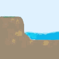
Cliffs can differ in size and steepness according to the amount and speed of erosion. The area between the high and low water mark of the cliff is the part mostly affected by the erosive power of the waves. This means that erosional landforms such as notches and wave–cut platforms could be observed at the base of cliffs.
Notches
and wave cut platforms
Maltese cliffs are made up mostly of Coralline Limestone, which is not a very resistant rock. Waves attack the base of a cliff and erode the limestone bit by bit, forming what is known as a notch. Eventually when the notch grows deeper, the overhang becomes too heavy to remain suspended and it collapses. This results in what is known as cliff retreat.
A
wave-cut platform is the gentle
sloping formation at the base of a cliff resulting from the process of cliff
retreat.
Notches and wave-cut platforms are very common in the Maltese Islands especially on Globigerina shores. (E.g. Sliema). This soft rock offers little resistance to wave attack and enables the formation of notches and wave cut platforms.
Bays
and headlands
Headlands
form due to difference in rock resistance to wave attack.
Less resistant rock is eroded more quickly and forms bays,
while the more resistant rock is left outcropping in the sea forming headlands.
A
discordant coastline is a type
of coastline characterised by a series of bays and headlands.
This coastline forms when rock bands are at right angles to the sea.
The softer rocks are eroded to form bays, while the harder rocks form the
headlands.
Coastlines
with different rock arrangement such as concordant
coastlines are less prone to the formation of bays and headlands.
The resistant rock parallel to the sea prevents the softer rock behind it
from being affected by coastal erosion.
Erosion of a headland: Cave, Natural arch, Stack and Stump

When
wave action has eroded the coastline into bays and headlands, headlands receive
a concentration of wave energy. The
process of wave refraction exposes
the headlands to further and more pronounced erosion.
Cave
The
first step in the process of headland erosion is the formation of a cave.
Waves exploit any joint or weakness
within the headland until these are widened into a cave. An example of such
formation in the Maltese Islands could be seen at the Inland
Sea in Dwejra Gozo and Blue Grotto in Zurrieq.
Blowhole/Gloup
When
a cave is formed, the power of the waves creates high pressures within the cave.
The air trapped inside the cave tries to escape through any vertical
opening or weakness. This opening is called blowhole
or gloup.
It is usually found at the top of the headland above the cave.
Natural
arch
Further
erosion of the cave will result in a natural
arch. This is formed when the
wave’s erosional power cuts through the headland. An example of such landform is ‘It–Tieqa’ in Dwejra
Gozo.
Stack
and stump
Wave
energy will continue to erode through the arch, especially its roof.
As with the case of the overhang, the roof will become too thin to
support itself. Eventually it will
collapse, leaving an isolated pillar called a stack.
The Fungus Rock is an example of
such a stack.
The stack, will then, be exposed to further erosion until it is all broken down into small pieces of rocks known as stumps.
Fieldwork: Coastal erosional features