
Located on Smith Island near the southern
tip of the Eastern Shore
in Northampton County

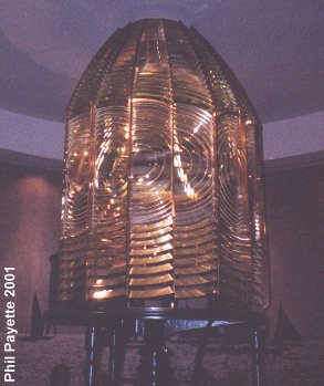
This lighthouse is a 191-foot iron tower reinforced by an octagonal pyramidal steel superstructure. It was built in 1894 almost a mile inland from the previous site. Although completed in December 1894, its Fresnel lens was installed late and the light finally was illuminated on August 15, 1895. The curent tower is painted all white except for the top section, which is black. It was automated in 1963 and the first-order Fresnel lens and the lantern were removed and replaced with a 5 second flashing airport-style searchlight beacon. It now shows a 1.2 million candlepower light, visible up to 24 miles away, the brightest in the entire Chesapeake Bay region. The Cape Charles Fresnel lens is on display at the Mariners' Museum in Newport News, and is shown in the pictures below. The lighthouse is operated by the U.S. Coast Guard and remains an active aid to navigation. It is not open to the public. On July 13, 2000 the keeper's house burned down. Since it was extremely difficult for firefighters to reach the island, they could not save the house. The first level's brick walls are all that remain. The lighthouse was undamaged.
HISTORY
The current lighthouse is the third one in this area. The first light
was a white 55-foot stone tower built in 1828. But light could only be
seen 12 miles away. The second light was a 150-foot brick tower located
1.25 miles southwest from the first site. It was completed on May 7,
1864. It was two years late because Confederate raiders completely
destroyed it when it was 83 feet high. It had a first-order Fresnel
lens. This tower was painted white with a middle band of red. The
lighthouse became a victim to beach erosion in 1892. Actually, the
condemned tower managed to stand until 1927. Rubble is still visible
in the surf. Six lightships served
near here beginning in 1888. The second ship started in 1891, the third
(what is now the Portsmouth Lightship) in 1916, fourth in 1924,
fifth in 1927. The station was moved in 1933 (served by a sixth ship) to
where the Chesapeake Tower now stands. Located near the lighthouse
are three towers that were used as artillery fire control and observation posts
for the gun batteries at nearby Fort John Custis. Two more Army towers
are located on Mockhorn Island just to the north of here. The fort was later
converted into the Cape Charles Air Force Base. The Eastern Shore
of Virginia National Wildlife Refuge now occupies the site of the World
War II fort. Except for a couple of bunkers and the towers, there is
very little evidence that the military was ever here.
Learn more about Fort John Custis.
Eastern Shore of Virginia National Wildlife Refuge: (757) 331-2760
Cape Charles Historical Society and
the Cape Charles Museum and Welcome Center: (757) 331-1008
Broadwater Bay Ecotours:
(757) 442-4363
HOW TO SEE IT
As you drive across the southern or middle sections of the Bridge-Tunnel you may be able to spot the two Cape Henry lighthouses.
2/19/06
return to port

 continue tour