SATELLITES
A Satellite is an object that moves around a larger object. There are natural
satellites such as moons and there are man-made
satellites such as the Hubble Space Telescope
Natural Satellite
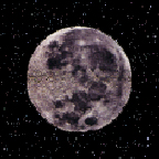
Celestial body orbiting a planet, asteroid, or star of a larger size. The most familiar natural satellite is the
earth's moon; thus, satellites of other planets are often referred to as moons. Within the solar system,
Pluto's moon, Charon, and the earth's moon are the largest satellites in relation to their planets, although neither is the largest in actual size. Ganymede of Jupiter is 3,268 mi (5,262 km) in diameter and is larger than the planet
Mercury. In comparison, some satellites are quite small, e.g., Deimos, the outer satellite of Mars, is c.4 mi (6 km) in diameter. Neither of the inferior planets, Mercury or
Venus, has a known satellite; all of the superior planets (those whose orbits lie beyond the orbit of the earth) except Pluto have at least 2 known satellites each
(Mars, 2; Jupiter, 16; Saturn, 18;
Uranus, 15—with another 5 awaiting confirmation;
Neptune, 8; Pluto, 1). A number of satellites, e.g., Phoebe of Saturn and Triton of Neptune, have retrograde motion and may be asteroids that were captured by the planet's gravitation. The asteroid Ida has a tiny moon, Dactyl, that is about a mile (1.6 km) in diameter and orbits about 60 mi (97 km) above Ida's surface.
Also See MOON
Artificial Satellite
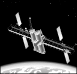
Object constructed by humans and placed in orbit around the earth or other celestial body (see also space probe). The satellite is lifted from the earth's surface by a rocket and, once placed in orbit, maintains its motion without further rocket propulsion. The first artificial satellite, Sputnik I, was launched on Oct. 4, 1957, by the USSR; a test payload of a radio beacon and a thermometer demonstrated the feasibility of orbiting a satellite. The first U.S. satellite, Explorer I, launched on Jan. 31, 1958, returned data that was instrumental in the discovery of the Van Allen radiation belts. During the first decade of space exploration, all of the satellites were launched from either the United States or USSR. Today, there are more than three dozen launch sites in use or under construction in more than a dozen countries.
 Types of Satellites
Satellites can be divided into five principal types:
a) Research
b) Communications
c) Weather
d) Navigational
e) Applications
Research satellites measure fundamental properties of outer space, e.g., magnetic fields, the flux of cosmic rays and micrometeorites, and properties of celestial objects that are difficult or impossible to observe from the earth. Early research satellites included a series of orbiting observatories designed to study radiation from the sun, light and radio emissions from distant stars, and the earth's atmosphere. Notable research satellites include the Hubble Space Telescope, the Compton Gamma-Ray Observatory, the Chandra X-ray Observatory, the Infrared Space Observatory, and the Solar and Heliospheric Observatory (see observatory, orbiting). Also contributing to scientific research were the experiments conducted by the astronauts and cosmonauts aboard the space stations launched by the United States (Skylab) and the Soviet Union (Salyut and Mir); in these stations researchers worked for months at a time on scientific or technical projects. The International Space Station, currently under construction, will continue this work.
Communications satellites provide a worldwide linkup of radio, telephone, and television. The first communications satellite was Echo 1; launched in 1960, it was a large metallized balloon that reflected radio signals striking it. This passive mode of operation quickly gave way to the active or repeater mode, in which complex electronic equipment aboard the satellite receives a signal from the earth, amplifies it, and transmits it to another point on the earth. Relay 1 and Telstar 1, both launched in 1962, were the first active communications satellites; Telstar 1 relayed the first live television broadcast across the Atlantic Ocean. However, satellites in the Relay and Telstar program were not in geosynchronous orbits, which is the secret to continuous communications networks. Syncom 3, launched in 1964, was the first stationary earth satellite. It was used to telecast the 1964 Olympic Games in Tokyo to the United States, the first television program to cross the Pacific Ocean. In principle, three geosynchronous satellites located symmetrically in the plane of the earth's equator can provide complete coverage of the earth's surface. In practice, many more are used in order to increase the system's message-handling capacity. The first commercial geosynchronous satellite, Intelsat 1 (better known as Early Bird), was launched by COMSAT in 1965. A network of 19 Intelsat satellites in geosynchronous orbit now provides instantaneous communications throughout the world. In addition, numerous communications satellites have been orbited by commercial organizations and individual nations for a variety of telecommunications tasks.
Weather satellites, or meteorological satellites, provide continuous, up-to-date information about large-scale atmospheric conditions such as cloud cover and temperature profiles. Tiros 1, the first such satellite, was launched in 1960; it transmitted infrared television pictures of the earth's cloud cover and was able to detect the development of hurricanes and to chart their paths. The Tiros series was followed by the Nimbus series, which carried six cameras for more detailed scanning, and the Itos series, which was able to transmit night photographs. Other weather satellites include the Geostationary Operational Environmental Satellites (GOES), which send weather data and pictures that cover a section of the United States; China, Japan, India, and the European Space Agency have orbited similar craft. Current weather satellites can transmit visible or infrared photos, focus on a narrow or wide area, and maneuver in space to obtain maximum coverage.
Navigation satellites were developed primarily to satisfy the need for a navigation system that nuclear submarines could use to update their inertial navigation system. This led the U.S. navy to establish the Transit program in 1958; the system was declared operational in 1962 after the launch of Transit 5A. Transit satellites provided a constant signal by which aircraft and ships could determine their positions with great accuracy. In 1967 civilians were able to enjoy the benefits of Transit technology. However, the Transit system had an inherent limitation. The combination of the small number of Transit satellites and their polar orbits meant there were some areas of the globe that were not continuously covered—as a result, the users had to wait until a satellite was properly positioned before they could obtain navigational information. The limitations of the Transit system spurred the next advance in satellite navigation: the availability of 24-hour worldwide positioning information. The Navigation Satellite for Time and Ranging/Global Positioning Satellite System (Navstar/GPS) consists of 24 satellites approximately 11,000 miles above the surface of the earth in six different orbital planes. The GPS has several advantages over the Transit system: It provides greater accuracy in a shorter time; users can obtain information 24 hours a day; and users are always in view of at least five satellites, which will yield highly accurate location information (a direct readout of position accurate to within 200 ft/60 m) including altitude. In addition, because of technological improvements, the GPS system has user equipment that is smaller and less complex. The former Soviet Union established a Navstar equivalent system known as the Global Orbiting Navigation Satellite System (GLONASS). GLONASS uses the same number of satellites and orbits similar to those of Navstar. Many of the handheld GPS receivers can also use the GLONASS data if equipped with the proper processing software.
Applications satellites are designed to test ways of improving satellite technology itself. Areas of concern include structure, instrumentation, controls, power supplies, and telemetry for future communications, meteorological, and navigation satellites.
Satellites also have been used for a number of military purposes, including infrared sensors that track missile launches; electronic sensors that eavesdrop on classified conversations; and optical and other sensors that aid military surveillance. Such reconnaissance satellites have subsequently proved to have civilian benefits, such as commercially available satellite photographs showing surface features and structures in great detail, and fire sensing in remote forested areas. The United States has launched several Landsat remote-imaging satellites to survey the earth's resources by means of special television cameras and radiometric scanners. Russia and other nations have also launched such satellites; the French SPOT satellite provides higher-resolution photographs of the earth.
|| Home || Aliens||
Quiz || Glossary || UFOs
|| Universe || Space Craft
|| Solar System
||