|
Technologies offered to the user for inventory, management and monitoring of Natural Resources in the areas:
AGRICULTURE
- Crop Acreage and Production Estimates.
- Status of crop and monitoring of crop growth.
- Frequency of cropping Single, Double, Fallow.
- Effect of natural calamity (Flood, Drought, Disease, infestation).
|

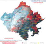
Rajasthan (Vegetative Cover, 2002)
|
- Inventory of irrigation resources.
- Land degradation studies Erosion studies, Watershed Planning, Wasteland Mapping, Saline Soils and Water logged areas mapping.
- Land Resource Development Planning, based on integrated approach.
|
SOIL CONSERVATION PLANNING
- Watershed delineation, characterization and development planning.
- Location of sites for Water harvesting structures.
- Delineation of Index catchment.
- Water Resource Development Plan.
- Sites for recharging of wells.
- Identification and delineation of Khadin sites.
- Soil Mapping.
|

Rajasthan (Vegetative Cover, 2000)
|
WATER RESOURCES
- Ground Water Exploration
- Recharge sites for Ground Water replenishment.
- Ground Water probable zones delineation.
- Hydrogeomorphological mapping.
- Surface Water
- Inventory of surface water reservoirs.
- Monitoring of surface water spread.
- Site selection for water harvesting structures.
|
GEOLOGICAL MAPPING AND MINERAL EXPLORATION
- Detection of lineaments, faults, fractures and sub-surface structures.
- Geomorphologic mapping.
- Rock type classification.
|
Rajasthan (Vegetative Cover, 1999)
|
IRRIGATION
- Inventory of surface water Reservoirs/ Dam's and assessment of water.
- Location of appropriate site for Dam/Anicuts.
- Delineation and characterization of Dams command and catchments including sub-mergence in
catchments.
- Planning for preventive measures to check ingress of silt into Dam.
- Mapping of flood affected areas and hazards effects.
- Monitoring of land use changes in command area.
- Crop Acreage Estimation in command areas.
- Identification of salt affected land in command areas.
- Mapping of water-logged areas.
- Canal alignment network.
- Status of water in canals over intervals of time.
- Water resources Development.
- Monitoring of surface spread of water in reservoirs over interval of time.
- Development of GIS for inventory of irrigation resources.
- Ground Water exploration.
FOREST AND VEGETATION MAPPING
- Spatial extent of forest cover.
- Density-wise classification.
- Forest species identification.
- Monitoring of forest extent.
- Site selection for new forest areas.
- Sites for Water Reservoirs within forest areas.
URBAN PLANNING
- Regional Planning for urban areas.
- Extents of urban areas and monitoring of their sprawl.
- Land suitability for urbanization.
- Urban encroachments.
PUBLIC WORKS DEPARTMENT
- Road network information system.
- New bye pass alignment based on GIS.
INDUSTRIES
- Site selection for new industrial areas.
- Present Status of Industrial areas in town.
- Degradation studies due to pollution from industries .
ENVIRONMENT
- Resource Inventory.
- Route and Corridor analysis.
- Command and catchment area. development.
DISASTER MANAGEMENT
- Draught Assessment.
- Draught Assessment due to floods, earthquakes, Cyclones.
GIS
DEVELOPMENT
- Development of information system based on spatial and non spatial information inputs for any of above activities and district level planning.
SHORT AND LONG TERM TRAINING
COURSES
- Remote Sensing and GIS for user departments, Teaching Staff of colleges/universities.
NOTABLE CONTRIBUTION TO:
STATE NATURAL RESQURCES MANAGEMENT
- Valuable database on watershed delineation and characterization at the micro level.
- Panchayat Samiti wise master plan for water harvesting structure sites.
- Ravenous area delineation in 10 eastern districts.
- Development of Watershed management Information System (WMIS).
- Bye pass alignment.
- Wasteland mapping.
- Integrated Resources Survey in 1/3rd part of 18 districts.
- Silt Prevention studies for Pushkar lake.
- Forest area mapping in Sirohi and Bundi districts.
- Cross Drainage works along Jodhpur Lift Canal (JLC).
- Hydrogeological and arable land use mapping.
- Crop Acreage and Production Estimates (CAPE) Wheat (21 districts), Mustard (15 districts) and Cotton (2 districts).
- Urban Studies Prithvi Raj Nagar Scheme (JDA), Jaipur City and other towns.
- Flood prevention inputs for Bharatpur and Alwar districts.
- National (Natural) Resources Information system- Digital data base on GIS platform for district level planning for Bharatpur , Dausa and Nagaur
districts.
- Environmental inputs study for : Sanganer Area for National Productivity Council.
- Ground water targeting in 4 draught hidden districts.
- Sorest evaluation along Aravalis through Remote Sensing and GIS techniques.
- Selection of Water supply route for proposed Mathania Solar Power Station.
- 25 Remote Sensing training courses organized.
FISHERIES
- Exportation of new fisheries grounds.
UNIQUE ATTEMPTS (MAIDEN IN COUNTRY AT STATE LEVEL
- Resource Atlas of Rajasthan.
- Watershed Atlas of Rajasthan.
- Ground water Atlas of Rajasthan.
VIDEO FILMS
- Remote Sensing.
- Resource Atlas of Rajasthan.
- Watershed management.
|