Links:
Guadalupe River Park and Gardens:
Part 1: Central - Coleman Road to the Arena Green
Part 2: South - Santa Clara Street to I-280
Part 3: North - Guadalupe Gardens to I-880
The Guadalupe River Trail: I-880 to Hwy 101
The Guadalupe River Trail: Hwy 101 to Alviso
Los Alamitos Creek Trail
San Jose Parks
Guadalupe River Trail
Guadalupe Creek Trail
Bay Area Biking
Bay Trail
Bay Area Parks
Bay Area Back Pages
SF Bay Rec & Travel
Guadalupe River Trail
I-880 to Hwy 101
The
newest section of the Guadalupe River Trail, from I-880 to Hwy 101,
opened in January 2008. It is only 1.7 miles long, but it is very
critical in that it joins two isolated trail segments into one long
trail, from downtown San Jose to San Francisco Bay. It begins at the
north end of the Guadalupe River Park (see Part
3: North-Guadalupe Gardens to I-880) and joins up with the
already-existing trail north of Hwy 101 (see The Guadalupe River Trail: Hwy 101 to Alviso).
The trail surface itself has been in existence for some time, as levee
service roads along the river bank. To make these usable as a safe
trail system required building undercrossings for the trail at the
roads crossing the river. These roads service the airport, so they are
very busy. Busiest of all is Hwy 101. Below are pictures and
descriptions of this new trail trail section.
Note that this is in an area that is undergoing extensive development, so is subject to changes and closures due to construction, as well as closures due to weather and water levels.
<>
Note that this is in an area that is undergoing extensive development, so is subject to changes and closures due to construction, as well as closures due to weather and water levels.

At
the north end of the Guadalupe River Park, the
trail goes under I-880, very close to river level. This is likely
to be underwater during heavy rains. The trail rises up to the levee
trail.

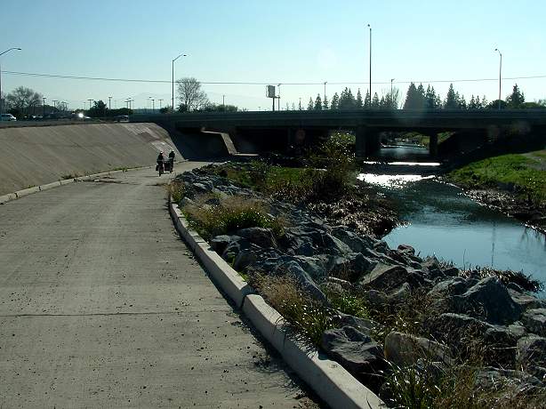
On
the other side of the undercrossing, from the top of the levee, looking
across the Guadalupe River, you can see a trail on the east bank
(currently not open) and Hwy 87.

From
here on, the trail is a straight hard-packed gravel levee service road,
paralleling
Airport Blvd. and Mineta San
Jose International Airport. The river is
far below except at the undercrossings. Future plans call for paving
the trail.

The
trail runs close to Airport Blvd. You can see the planes and airport
buildings. Above is Terminal C, with terminals B and A beyond.

After
awhile, the trail reaches the Skyport Drive undercrossing. There are no
access ramps from the trail to the road.

This
is a view of the Skyport Drive bridge from the undercrossing. The
trail is close to the river level, so may be flooded in high water. The
closed trail on the east side of the river also goes under the bridge.

The trail passes by the airport terminals. Above is the new Terminal B, under construction.

The
trail reaches a paved section near Airport Parkway. It splits into two.
One route goes under Airport Parkway and continues on the west bank of
the river. The other crosses Airport Blvd. to reach the trail on
the east bank. Both routes will be shown below.

Airport
Parkway undercrossing.

The
safest way to reach the east bank trail is to cross under Airport
Parkway and cross over on the north side of the bridge, which has a
separated 2-lane walkway/bikeway.

On
the south side of Airport Parkway, the trail is closed (as of this
writing), so the trail cannot be reached from the south side of the
Airport Parkway bridge without crossing the street.

On
the north side of Airport Blvd., the trail is open on the east bank of
the river, next to Hwy 87. It is paved for a short distance.

The
trail is a wide dirt service road, which may be soft and rutted after
the rains and construction traffic. This will be paved in the future.

On the other side of the river is the airport's terminal A short-term parking lot.

The trail continues through a gate as it approaches the rental car parking lot.

The
trail widens out as it passes by the rental car parking lot. Ahead is
the undercrossing, which will be shown below.

Going
back to the Airport Parkway Bridge, this is the trail on the west back
of the Guadalupe River. It is hard-packed gravel, so it is a firmer and
dryer surface than the east side, at this time, so may be a better
route in wet weather.

The west bank trail ends at the bridge to the rental car parking lot

To
continue on the trail, cross the bridge. There are sidewalks, but no
bike lanes on the narrow 2-lane bridge, so be careful crossing it.

This a view looking south down the east bank trail, next to the rental car parking lot.

The trail goes under the rental car parking lot bridge, running close to the river.

A short distance beyond is the Hwy 101 undercrossing.

Looking across to the west bank, there are only rocks, no trail.

The trail rises up to on a long ramp to the top of the levee on the north side of 101.
Looking back at the Hwy 101 undercrossing.

Looking
north, the trail runs on both side of the river, but only the east side
goes under 101. Both sides go all the way to Alviso. The east side is
in San Jose. The west side is mostly in Santa Clara. For more on this
section, see the Guadalupe River Trail:
Hwy 101 to Alviso.
Created by Ronald Horii 1/20/08. Photographed 1/19-20/08.