Links:
Guadalupe River Park and Gardens:
Part 1: Central - Coleman Road to the Arena Green
Part 2: South - Santa Clara Street to I-280
Part 3: North - Guadalupe Gardens to I-880
The Guadalupe River Trail: I-880 to Hwy 101
The Guadalupe River Trail: Hwy 101 to Alviso
Los Alamitos Creek Trail
San Jose Parks
Guadalupe River Trail
Guadalupe Creek Trail
Bay Area Biking
Bay Trail
Bay Area Parks
Bay Area Back Pages
SF Bay Rec & Travel
Guadalupe River Park and Gardens
Part 2 South: Santa Clara Street to I-280
This
page covers the south part of the Gudalupe River Park and Trail,
beginning south of Santa Clara Street, and ending at the park's
southern boundary just past I-280.
This is a view of the trail and river from the Santa Clara Street Bridge. The trail is only on the east bank of the river.

On
the south side of Santa Clara Street is a series of sculptures, called
"Remembering Agriculture" by Tony May. These structures, which are
shaped like farm buildings, serve as arbors for climbing plants.
This is the Santa Clara Street under-crossing on the east bank of the river.

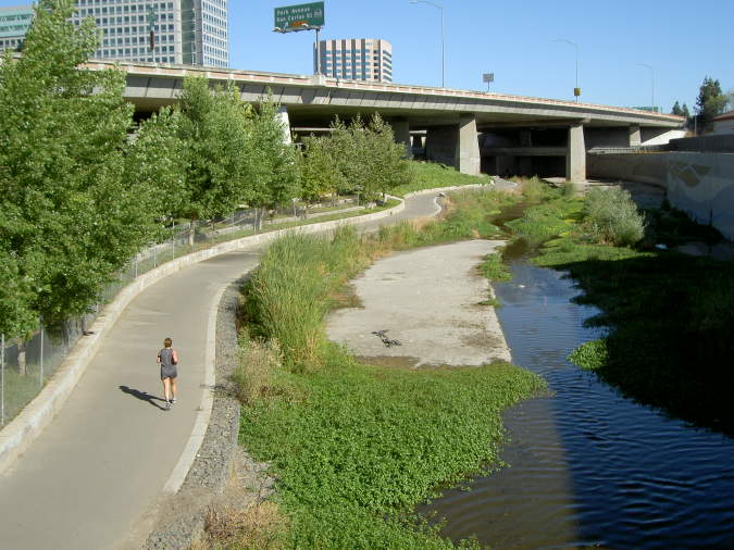
The trail runs along the river and close to it below Hwy 87.

This
is a view looking back towards the Santa Clara Street Bridge. The San
Jose Water Company building is on the left.

The trail runs under Hwy 87 here.

This is the ramp leading up to Park Avenue.

This is a view looking south down the riverbed towards the Park Avenue bridge.

Looking
across the river from the east bank towards Park Avenue and the west
under-crossing. Ramps and stairs lead down the trail. Terraces line the
banks. The trail on the west side close to the river level starts here.

These terraces are on the east side of the river below the Adobe building. Ahead in the background is McEnery Park.
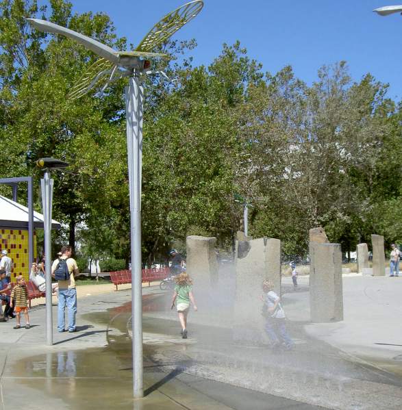
McEnery
Park is named after prominent San Jose civic leader John P. McEnery,
father of former San Jose mayor Tom McEnery. It's located on San
Fernando Street on the east bank of the Guadalupe River. It has play
structures inspired by the river. These water sprays originate near
large rock-like structures that are reminiscent of the mists and
boulders in the mountains where the river begins. Dragonflies, a common
river insect, are suspended in the air over the park users. A restroom
building is on the left.

The
water in McEnery Park flows through a sandy area, simulating the sandy
foothills, and then through this channel, like the river flowing
through the city's plains. (Note: the park's fountains were turned off
in September 2006 because of fears of infection by the parasite
Cryptosporidium. The fountains will likely stay off until they can be
made safe.)
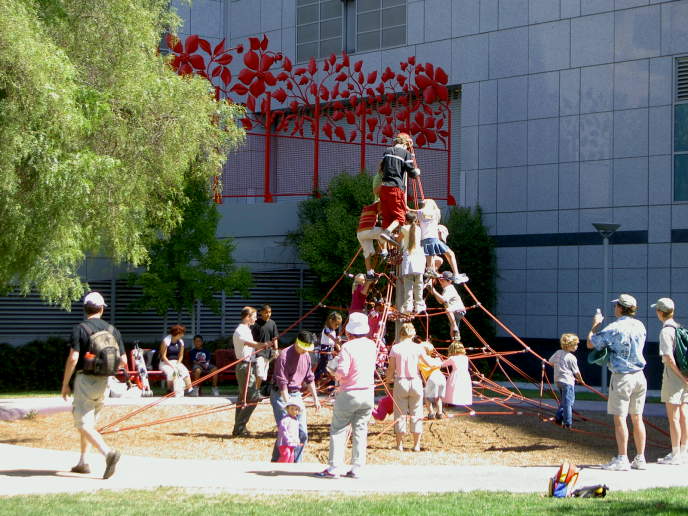
McEnery
park has this pyramidal rope climbing structure. In the background is
the Adobe headquarters building.

West
on San Fernando Street, west of the Guadalupe River is the San Fernando
Light Rail station. In front are three painted lions in a sculpture
called "Life Is a Circus."

The
high trail on the west side of the river begins at San Fernando Street
and runs along the concrete wall above the river. Here is one of the
flood control outlet conduits. Above it is the Park Avenue Overlook
Plaza.

On
the Park Avenue Bridge are animal sculptures of a coyote, eagle, and
hummingbirds, honoring the Muwekma Ohlone Native Americans. These
animals are featured in the Ohlone legend of creation. The coyote above
was the creator of the human race.

East of the river on Park Avenue and Almaden Blvd. is San Jose's Center for the Performing Arts.

On
the east river bank, on the south side of Park Avenue, is the Veterans
Memorial. This consists of 76 white flags and glass panels inscribed
with letters to home from military personnel in various wars.

This is the Okayama, Japan Sister City sculpture, illustrating the Japanese tale of Momotaro, the Peach Boy.

South of the Veterans Memorial is a pedestrian bridge over the river.

This is the trail on the west side of the river, with the pedestrian bridge overhead.

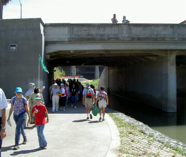
The west bank
trail goes under West San Carlos Street. On the other side, the trail
continues. There are stairs leading up to the Discovery Meadows.
Terraces provide seating areas under the shade of the trees.

Discovery
Meadow has a very large lawn area that is frequently the site of
outdoor events. At the north side are picnic tables and bronze animal
sculptures, which represent river animals. The large dice are for the
Monopoly in the Park game. Across the lawn is the Children's Discovery Museum.

This
is Monopoly
in the Park. This 930 square foot
Monopoly game board is the largest Monopoly board in the world. Large
game pieces can be rented to play an actual game of Monopoly.

Leading
across the river at the Discovery Meadow is the Children's Bridge. This
is a cable-stayed suspension bridge. The tower at the east end has two
large cables that support the center of the bridge. In the foreground
is a sculpture that represents children playing.

Past
the Children's Discovery Museum, the trail drops down to river level
and goes under the Woz Way bridge. Just beyond, the trail ends at a
ramp leading up to the Woz Way Overlook and Woz Way itself.

These are the terraces along the east bank of the river south of Woz Way.

To
continue south on the trail, cross over to the east bank via the Woz
Way Bridge. The bridge is near the south end of the park.

This is a view
of the river looking south from the Woz Way Bridge. Ramps and stairs
lead down to the trail on the east bank of the river. Ahead are I-880
and its on-ramps and off-ramps to Hwy 87 to the west. The trail runs
below these.

From the east
side trail, this wall on the west bank of the river shows flood water
levels and flow rates associated with each. In the summer, the river is
well below these levels, but in the winter, the flows can be
considerable. Downtown San Jose has been flooded many times in its
history. The flood control project is designed to prevent these floods.
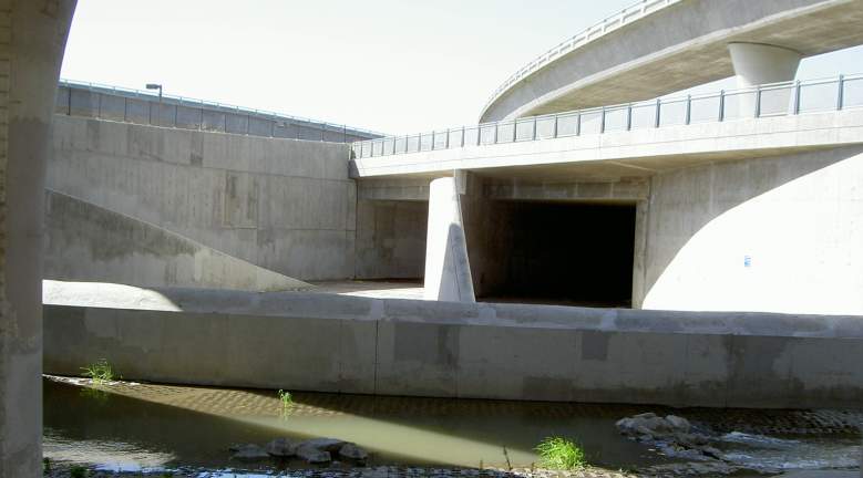
From
the East bank trail, the huge flood control inlet culvert can be seen.
This is the beginning of the flood control project. The trail currently
ends just beyond here at a culdesac at the end of Grant Street. The
next section of trail is far south of here at Chynoweth Avenue at the
begining of the Guadalupe
River, Guadalupe Creek, Los Alamitos Creek, and Calero Creek Trail
complex.
Created by Ronald Horii, 7/19/07, updated 1/21/08