MAPPING
| MAPPING |
|
 Being able to read and understand maps is a useful tool not just in scouting. Maps are used by ordinary people outside the movement ever single day and it is important for us to understand them. This page looks at teaching the basics of map reading and compass work that is required for the South African Map reading scoutcraft badge.
1: Know some of the different types of compasses that are available, and explain how a compass works. Know some of the problems that can occur in using a compass, and how to overcome these.
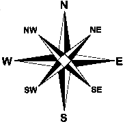
There are two common compasses you will come across in scouting and these are: The simply mapping Simple mapping compass and the Prismatic Compass. The simply mapping compass is as it sound, it has compass needle is mounted in a compass house, while the prismatic compass has a few extra features: like the a sight (which makes it more accurate).A compass points to a certain point on earth, which is called the magnetic north. This happens due to fact that the earth has a magnetic force, which pulls the compass needle towards it. The north end of the needle is normal red and the south end black.
Most of the problems involved with using a compass come from it pointing in the wrong direction. Now this could be due to a number of different factors, but they all have the same problem of using a compass near a magnetic field or metal. Eg: a metal table, clip board, under power lines, etc.
Another problem is taking a reading at an angle. If you point the compass up or do not hold it flat the needle will stop moving and you will not get the correct reading.
2: Know the difference between: (A) True North, (B) Grid North and (C) Magnetic North and demonstrate the ability to find each of these, both on a map and on the ground.
True North: Is the direction of the North Pole from that point. Simply put, it is the direction of the North Pole from where you are measuring with a compass. All Government topographical maps are drawn with their grid lines and margins based on True North.
Grid North: Refers to the North point of all the north/south grid lines on a map. I.E The grid lines on a map are grid north and are not True North, but are placed parallel to it.
Magnetic North: Refers to the direction that a compass needle will point if left to rotate freely. This is the point that the earth forces will move the needle towards. It is not the same as True North or Grid North.
3: Explain the cause and effect of magnetic declination, and know the relationship between true bearings and magnetic bearings. Demonstrate how to convert bearings on a map to compass bearing and vice versa.
|
Magnetic declination is the difference between Magnetic North and True North. An example of this would be the difference between the degree from "B" to Magnetic North and True North. From this we can gather that magnetic declination is different in different parts of the world. The magnetic declination also changes slightly each year as the position of magnetic north changes. Looking at A we can also see that the declination can be to the west for some like in A, while to the east for others like in D. |
 |
4: Demonstrate a working knowledge of bearings and backbearings by being able to:
(A) Identify a feature from a map, by taking bearings to locate it on the ground.
Features on a map are listed in a key index. Taking a bearing of an object refers to getting its position by use of a compass. This can be done by facing the compass at the object, keeping it flat and steady. Rotate the compass housing until the needle comes to rest inside the North/South Marker (the arrow that faces north). With regards to taking it from a map, find out where you are on the map. Once you know this you can find out the degree that the object is from where you are and then just set the degree on the compass by turning the compass housing.
(B) Carry out an exercise in the field to determine your position on a map by the resection method using backbearings.
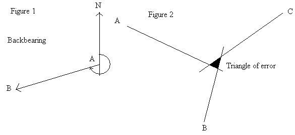
A backbearing refers to the direction from an object to a position (i.e. where you are standing). We use backbearing to work out the direction from the object without actual having to go there. In figure 1 we need to get a bearing from A to B, this can be done by taking a backbearing of A from point B and adding 180 degrees. If this comes out at more than 360, subtract 180 to get the backbearing, as a compass can only measure up to 360 degrees, as it is a full circle.
The resection method is used to determine your position on a map. For this you will need to identify three landmarks that are on the map. It works best if they are evenly space (120). First, you need to take a bearing of the first landmark (A). Then subtract the declination to make it a true bearing, as the map faces true north and you are trying to find your position from landmarks. You then to convert it to a backbearing (add 180 or subtract 360). Once this is done draw a true north/south line through (A) about 150mm each side of (A). Then place your protractor/compass on the line and mark the backbearing on the map. Draw a line through A and the backbearing, as you are somewhere on that line.
Now we need to do the same for (B), as well as (C). This will give you a triangle, called the triangle of error in which you are located. If the lines do not intersect you, have done something wrong.
(C) Use a magnetic compass to follow a compass trail of about one kilometre in length, consisting of seven or eight distances and bearings (both True and Magnetic).
This requirement should be done on camp or a Friday night anyway, but if it is not then ask one of your scouters or senior scouts to setup one for you. This should be done on a farm or in a rural area, as a street trail is to easy and does not test you skills correctly. The main thing to remember is to subtract the declination of the true bearings. It’s easy to cheat the system, but not as easy to cheat yourself!