

 CANADA

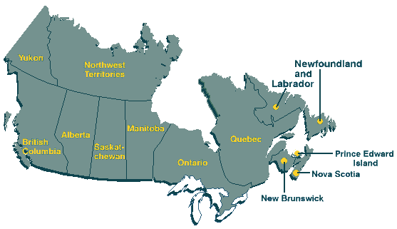
Canada is made up of 10 provinces and 2 territories, soon to be 3. Nunavut is a new
territory, designated to be declared officially that on April 1, 1999. It's formation is a
result of splitting the Northwest Territories in two. Canada's Confederation is celebrated on
July 1, we became a country in 1867. Ottawa, the capital, is in the
province of Ontario. Ontario was one of the first provinces to enter Confederation,
joined by Quebec, Nova Scotia and New Brunswick.

On the west coast of Canada is British Columbia. It
joined Confederation in 1871 and is the home of the beautiful Rocky Mountains. The
capital, Victoria, is
located on the southern tip of Vancouver Island. From the Pacific Ocean view to the
rugged interior, B.C. is truly, in my opinion, the most majestic of the Canadian
provinces.

Travelling east will bring you to the most western of the prairie provinces, Alberta. Alberta joined Confederation in 1905 and
is most renown for it's ski resorts and vast quantities of oil. The western part of the
province is mountains and foothills, gradually levelly out to prairies and windswept fields
of pastureland and grain. The capital, Edmonton, is home to the world
famous, "West Edmonton Mall", a must see
for anyone who visits Alberta.

Next, heading east is
Saskatchewan, my home province. This
province joined Confederation in 1905 also. Saskatchewan the "bread basket" of Canada,
is the middle of the 3 prairie provinces and is home to Scotty, the T-Rex fossil discovered
in Eastend, in the South Eastern corner of the province.

Last, but not least, of the prairie provinces is Manitoba. Winnipeg, the capital, is home
to the World famous "Royal Winnipeg Ballet". In
1870, Manitoba became a province of Canada.

Still heading east, we now come to the second largest, and most populous of the
Canadian provinces, Ontario, one of the
original members of Confederation. Northern Ontario is home
to many mining communities. The Canadian Shield provides this area with an
abundance of natural elements, including nickel and copper. Toronto, the provincial capital, located in
Southern Ontario, is the largest city in Canada, and is Canada's leading manufacturing
center. The name Toronto, is derived from a Huron word meaning "place of meeting".
In close proximity to Toronto, there are many attractions available to all. One of the best
known places in the world, Niagara
Falls, is a couple hours drive from Toronto. Niagara Falls was formed around
12,000 years ago, when the glaciers retreated north. There is much to see and do in
Ontario, it is "Yours to Discover".

The largest of the Canadian provinces is Quebec, also one of the original
members of Confederation. This province is primarily covered by the Canadian Shield,
which yields an abundance of gold, silver and copper, as well as other base metals. The
largest city, Montreal, and the
provincial capital, Quebec City, are
located in the southern part of the province. The northernmost reaches of Quebec, are
covered by permafrost. The great majority of Quebec's inhabitants use French as their
primary language.
Lastly on the Atlantic coast of Canada are the four provinces collectively called the Atlantic provinces. Two of
these provinces, New Brunswick and Nova Scotia, were original members of
Confederation in 1867 as well. The remaining two island provinces, Prince Edward
Island, and Newfoundland, became part of Canada in 1873 and 1949 respectively. Nova
Scotia, New Brunswick and Prince Edward Island are also sometimes referred to as the
"Maritimes".

New Brunswick, one of the Maritime
provinces, is a blend of: coastal lowlands, containing fertile soils: plains covered with
rich soils built on glacial deposits, and the rocky, rugged terrain of the north, make for a
very diverse terrain. Fredericton, the capital, lies in the
south central part of the province. The province is 90% forest covered. Although
forestry is the economic mainstay, fishing, agriculture, tourism and mining combine to
make the economic structure as diverse as the landscape. The maritime phenomenon, the
reversing falls near Saint John, are caused
by the extreme high tides on the Bay of Fundy.

Nova Scotia, "Canada's Ocean Playground", is
Canada's smallest continental province. Forests cover 3/4 of the land area, and forestry is
one of the major economic industries, mining, fishing and farming contribute to the
economy also. Nova Scotia is know for its abundance of wildflowers. Halifax, the provincial capital, is a major
seaport, and has ferries linking it to the other 3 Atlantic provinces. Halifax harbour was
the site of a
munition ship explosion in 1917, during World War I, during which 1900 people
were killed instantly. Halifax is also the home of the museum which houses the artifacts
from the Titanic, including one intact
deck chair. There are around 300 victims of the sinking interred in various cemeteries
throughout Halifax.

Prince Edward Island, our tiny island province, is
famous for its iron rich, red soil, a fertile surface, as a result of glacial deposits. Potatoes
thrive here and are a most valuable crop. Fishing, of course, is also a very important
industry, with lobsters bringing in the most revenue. Tourism is another major source of
income for this tiny province.
Charlottetown, the capital, is the birthplace of Lucy Maude Montgomery, author of
"Anne of Green Gables". If you are interested in this author, there is a very good link to a
site about her on the PEI link.

Newfoundland and Labrador, last but not least
of the Canadian provinces, are on the extreme east coast of Canada. The land area is
mostly rugged mountainous terrain. There is very little agricultural land anywhere in the
province. Up to the beginning of the 20th century, fishing was the dominant economic
industry, but with overfishing on the Grand Banks, the province has turned to mining as
the prominent industry. St. John's, the
capital, is located on the south shore of the island, and is the oldest city in North
America. Most of the cultural institutions are located there. It was visited by John Cabot
in 1497, however, there is evidence that there were inhabitants there as early as 1000.
The Grand Banks, located southeast of Newfoundland, is one of the world's richest
fishing grounds.
Next, we will travel to the far north. Collectively known as the territories, the far
northern reachs of Canada include the Yukon Territory, and the Northwest
Territories.

The Yukon Territory, the far northwestern part of
Canada, entered Confederation in 1898. It is a land of mineral wealth and scenic
diversity, and very sparsely populated. The capital, Whitehorse, was the scene of interesting
times during the great gold rush. Mount
Logan, Canada's highest mountain, and North America's second highest, is located here.
Robert Service, the poet, spent
much of his adult life in the Yukon.

The Northwest Territories includes all the
area north of the 60th parallel except for the Yukon. The capital city, Yellowknife, is located in the south central part
of the region. The territory comprises an extensive mainland and thousands of
mountainous islands. It entered Confederation in 1870, and covered more than 1/3 of the
total area of Canada. The Northwest Territories has a varied surface, from the Canadian
Shield in the east to the interior plains, and Rockies in the west. The area is rich in
mineral resources, including gold, silver, and uranium. The old boundaries of this area have recently changed, and in 1999 a new Territory called Nunavut was formed in accordance with a land claims agreement with the indigenous people.
The new Territory, Nunavut, is self-governed by the Inuit people. It encompasses about 1/5th of the land mass in Canada, and is by definition, a desert. The name, Nunavut, means "Our Language".
I guess this pretty well covers Canada, there is so much to share with others about our
beautiful land, that it is almost impossible to take you all the places here I would like to.
There are many other great places and links all over the web about our homeland. Take
some time to get to know us and it, there may be a lot of things about us (Canadians), that
you find interesting and entertaining. Take care, have fun, and be sure and sign our
guestbook.
© 1997