Sorry for the hack website. I'm tired and need to sleep. Suffice it to say that internet aesthetics isn't a high priority at the moment. As of now (30 October), only pics from my digital camera are up. Converted Mini DV camcorder images will be added later. And sorry for the dry commentary.. I'm too tired to be witty.

Monday, 27 October 2003

So, uhm, yeah. Over the weekend, we could see bits of smoke from the Piru, Verdale, and Simi fires even though most were pretty far away. Yet, I knew that things were going to get bad given the commotion -- all of the fire engines, air tankers, news coverage, etc. -- that the fires were receiving. On my way home from CalArts, I saw LOTS of smoke and maybe 7 air tankers in the area. It was then that I decided to grab the cameras.

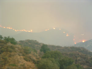
The Simi Fire from the I5 (around 4PM). To the lower left of the image are a row of houses on the top of the small hill I live on, as well as part of my apartment complex right below that.

By the time I went to bed, the fires were roughly 7-10 miles away.


Tuesday, 28 October 2003

By the time I got back from class (around Noon), the fire was much closer, but still far away. I took these two shots from the parking lot closest to my apartment. You can even see part of the air armada in the second one.

Of course, given that the fire was still far away and since I was pretty tired, I decided to take a nap before heading back to school to tutor an undergrad. By the time that I woke up (around 2:45 PM), things were much different.


The wind had changed direction and smoke filled the entire Santa Clarita valley. The haze was an unusual color, a combination of the bright sun, grey smoke, and the orange and red flames. Anyhow, I decided to walk to the other side of my apartment complex to see if I could see anything.


Yup. I could see something. Fire. Here's a shot of the line of flames that was approaching the Stevenson Ranch area from the Southwest. At this point, the fire was about 3 miles away. The picture is a bit blurry because my digital camera's autofocus was confuzzled because of the smoke.

At 5PM, we got the announcement that our area of Stevenson Ranch was under a voluntary evacuation. I started packing and loading the car just in case.


Wednesday, 29 October 2003

Yeah. Things got interesting real quick. I got up at 7:30AM to see if things were getting worse. In ways they were, but still no mandatory evacuation. I went back to sleep. But how well can you sleep if you have no idea on when the mandatory evacuation is called?

Things were bad by the time that I woke up (11:30AM). The smoke was bad enough that the air tankers were grounded. Helicopters were fine though. Then the wind shifted direction. The fire was about a half mile to the South of me and the wind was blowing to the North. Mandatory evacuation called for the houses on the other side of my hill. Time to leave.

Aerial View of my area (file map from mapquest.com)

Loaded up the cat and headed out. The view looking to the South from my parking lot at Noon (right). I headed North to the WalMart parking lot to get a better look from a safer distance. Check out how fast the smoke was covering the area. The time span between the two pics (below) was something like 10 mins.

Yeah. Pretty gnarly. I randomly bumped into a friend at the WalMart parking lot -- she was stuck there since she couldn't get back to Pasadena since the I5 was closed -- and we went to Subway and Starbucks. Dottie slept and shedded in the car.

By 6PM, the reports were in that the area was relatively safe. Apparently helicopters with the large buckets o' water dropped upwards of 30 times along a one mile stretch of fire. That, along with the line of firefighters along the top of the hill, stopped the flames in their tracks. So I went home and slept.


Thursday, 30 October 2003
I'm still tired. Need to sleep more. I went over to the area today that was under the mandatory evacuation to see if I could see anything, but I really couldn't. There were still about 15 fire engines in the area as a precautionary measure, as well as a bulldozer. These were the best shots I could get without asking one of the residents..

And here's a section from a MODIS Fire Map made at 7AM, 30 October. I *think* I'm somewhere between the first 'n' in 'Simi Incident' and the mass of red and yellow right below that. BTW, the yellow areas indicate an area that has already burned and the red areas indicate active fires.

Anyhow, that's it for now. Will convert the video images to stills when I get a chance. Need sleep.