Difficult Run
  The Stream
  History
  Colvin Run Mill
  Interesting Places
  Connecting Trails
  Public Transit
  10-mile Circuit Hike
  Cue Sheet (Circuit)
  Cue Sheet for Trail
  Elevation Profile
  Photographs
  Parking

Welcome To The Difficult Run Trail
A tranquil trail five miles from the turmoil of Tyson's Corner.

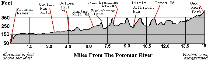
A Long-Distance Hiking Trail in Fairfax County, VA. This trail is the northern half of The Cross-County Trail. See the website of Fairfax Trails and Streams for more information.

Beginning beside rapids on the Potomac River, the Difficult Run Trail follows its namesake, Difficult Run, into
Map of Difficult Run Trail
Browsable map of Difficult Run Trail.  
the heart of Fairfax County. This trail avoids housing developments for many of its fifteen miles. Less than a quarter mile is on roads. How is this possible? Because the county banned the construction of housing in flood plains, the banks of Difficult Run form a linear park. Imagine walking for miles without seeing cars in Fairfax County, the largest suburb of Washington, D.C.!

The Difficult Run Trail: a community effort.

Related Sites

Northern Virginia Hiking Club
This group of hikers has sponsored numerous hikes over the Difficult Run Trail. They support the Difficult Run Trail, so we support them.


Use the trails wisely. The conditions of the trails may vary from the descriptions found here, due to external forces. This site strives to present accurate information, but it is subject to change. Never trespass on private property or violate any law. Do nothing which would be dangerous. As with any activity outdoors, hiking has risks. You assume responsibility for those risks.


Many Trees Along The Trail Planted by the:

VIRGINIA DEPT. OF FORESTRY'S DIFFICULT RUN PROJECT

Difficult Run Forestry


COLVIN RUN MILL PARK AND VILLAGE

The Other Half of The Cross-County Trail:
ACCOTINK CREEK TRAIL

Last updated Dec. 12, 2002.

Send an email to the person who maintains these pages.

Guide to these pages | Search This Site<