

|
|
|
|
|
|
|
|
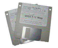 So I found these disks... ...and I want to know what I'm supposed to do with them. What you found are 3.5" computer disks containing a Digital Raster Graphic (DRG) for cache's area. What you need to do is visit my links page and follow the link to ESRI to get ArcExplorer. After you have ArcExplorer installed, put the first disk from me in your disk drive, open windows explorer (My Computer), navigate to the A: drive and double click the file with the .EXE on the end. Follow the prompts, and if you accept all the defaults, windows will put a .TIF and .TFW file in a folder named "utmdave" on your C: drive. (You can also direct this to another location.) Open ArcExplorer and add the image as a theme. Check the on-line help or PDF manual to learn more about how to use ArcExplorer. All this software is for Windows. If you use Linux, send me an email and I'll tell you where you can download the DRG. ArcExplorer has a Java edition that runs in Linux. Why is "utm" in front of your name? UTM stands for Universal Transversal Mercator which is usually the map projection for USGS 7 1/2 minute maps (Quadrangles) which I frequently use to produce mapping. The items I leave behind in geocaches are USGS Quad maps in ...UTM projection. (Yes, I'm lame.) You can learn more here. |
What is Geocaching? Geocaching is a game for owners of GPS units. The object is to find hidden "caches" (say cashes) by entering the coordinates into a GPS and navigating to the hiding place. You can learn more here. |
|