
![]()
![]()
![]()
![]()
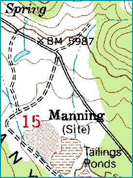
Map of
USGS 7.5 Minute Series Map "Mercur"
Brief History
Manning depended upon the good fortunes of the town of Mercur; but this was not to be a reciprocal relationship. Manning received its name (as did Manning canyon) from one L.S. Manning, a promoter of the use of cyanide in the processing of ores (Thompson, 20).
It was water near Manning that made the area valuable for Mercur and made the area a prime site for a mill. In the late 1880's, a mill was constructed to process ores from Mercur (Carr, 29). In 1890, the mill was remodeled by the Mercur Gold Mining Company to use a new cyanide process to leach gold out of ore - the result: the first operating cyanide mill in the United States (29). The mill was enlarged in 1893 to accommate 100 tons of ore; in 1896, it was expanded to accommodate 200 tons and again to 350 tons (Alder, 35). The average amount of gold obtained from the cyanide process in Manning in 1896 was one-half ounce of gold per ton of ore; by 1912, the figure had dropped to one-fourth the 1896 figure (Alder, 36).
A standard gauge rail line (the Salt Lake and Mercur RailRoad) was built between Manning's mill and Mercur's ores. It was completed on January 21, 1895 (Thompson, 21). The tracks were eventually extended to Fairfield to connect with the Union Pacific lines, which opened up the possibilities of passenger travel to Mercur.
Manning's mill was given a death sentence in 1898 with the construction of Mercur's famed Golden Gate Mill. The mill was constructed in Mercur and was thus closer to the ore bodies, which shut the Manning mill down.
Manning was resurrected briefly from 1933 to 1937 when a new mill was built to process lower grade ores and old tailings. This new operation was called a "counter current decantation cyanide plant" and operated on the site of the old Manning mill (Alder, 42).
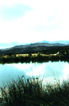
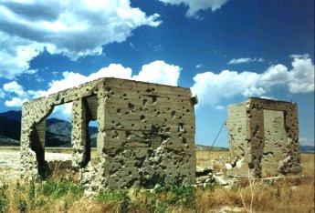
Manning today consists of mill foundations, dried up tailing ponds and desert landscape. There is also a rather nice spring located in Manning and an artificial pond (at least it looks man made) with fish in it. On the way to Manning there are some photogenic ruins which are worth taking a look at located on an abandoned railroad line.
The sources I consulted for Manning say nothing of population figures, what sort of businesses (if any) existed. In fact the source material is rather sparse. If you have information on Manning use the e-mail link and let me know.
Alder, Douglas, D. "The Ghost of Mercur" Utah Historical Quarterly Vol. 29 No. 1 January, 1961.
Carr, Stephen L. The Historical Guide to Utah Ghost Towns
Thompson, George A. Some Dreams Die: Utah's Ghost Towns and Lost Treasures
Consulted but not cited:
Goodman, Jack. "The Shining Mountains - The Oquirrh Range" Utah Historical Quarterly Vol. 27 No. 3 July, 1959.
Pictures
Click on the thumbnail for larger photo.
All photos copyright (c) Chad Carter 2000.


All photos copyright (c) Chad Carter 2000.

All photos copyright (c) Chad Carter 2000.
The above two photos are actually of ruins located on the way to Manning and are not
part of Manning proper.
Video Clip
Here is a 43 second (968 kb) video clip of Manning. It was taken with a digital camera without the benefit of a tripod so the quality and steadiness isn't the best. However it is still usefull to see the general area of Manning and a few of the remaining foundations.
I suggest 'right-clicking' on the link and saving the file.
![]()
Utah Ghost Towns and Mining Camps
All photos and graphics (unless noted otherwise)
copyright (c) Chad Carter 2000.
Created in 800X600 resolution.