


End of US highway 195
|
Approx. time
period
|
North Terminus
|
South Terminus
|
|
1926-1969
|
Sandpoint, ID
|
(near Lewiston, ID)
|
|
1969-present
|
Spokane, WA
|
(near Lewiston, ID)
|

(about 54 k)
Note: since I don't have access to a comprehensive collection of historical
road atlases, much of the info on this page is based on the research of Mark
Bozanich and Robert
Droz. Photo credits: Chris
Elbert; Stephen
Taylor; SRweb
(WA DoT's web-based state route viewer). Maps and additional photos: me
The western border of Idaho follows the Snake River northward from
around Payette, all the way up to its confluence with the Clearwater
River. At the point where those two channels converge, in the city of
Lewiston, the Idaho line heads due north to the international
boundary with Canada - while the Snake exits Idaho and begins flowing
through the state of Washington. The lowest elevation in Idaho is at
that spot: 738 feet. This low-lying area is known locally as the
Lewis-Clark Valley. Thanks to a series of locks and dams on the
Columbia and Snake rivers, Lewiston is able to serve as Idaho's only
seaport. As a matter of fact, it is the furthest-inland seaport west
of the Continental Divide. For more info on highways there, please
see my Lewiston
page.

Streams in this part of the country tend to cut deep, narrow gorges - rather
than wide, gentle valleys (I'm told it's because the rock is primarily igneous
and metamorphic, as opposed to sedimentary). South of Lewiston, the Snake River
carved the famous Hells Canyon (which is actually deeper than the Grand Canyon
in Arizona). North of the city, the walls formed by the Clearwater rise abruptly
to a plateau averaging perhaps 2000 feet higher than the Valley. The prairie
up there is called "The Palouse". (Pronounced "puh-LOOSE", it's a Nez Perce
word, from which the Appaloosa horse breed takes its name.)
Now, finally, to the subject of highways: From Payette, US 95 runs north to
Lewiston. Then it climbs what locals call "The Grade", seven miles up "The Hill",
onto the Palouse. Continuing north along the Idaho border from there, US 95
serves the university town of Moscow, and then on to Coeur d'Alene. On the map
above, I've highlighted US 95's original route in green. The map below shows
the junction to the north in more detail:
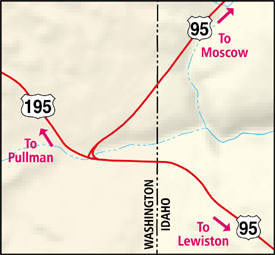 c. 1926 - 1970's
This map shows the junction of US 95/US 195 junction as it was
until the mid-1970's. As you can see, US 95 used to cross just inside
Washington before angling back into Idaho. Now it stays entirely
within the state of Idaho (compare to map below). US 195 used to be
entirely in Washington, but now the south end of US 195 extends a bit
further, along US 95's old route, to just inside the Idaho line. The
north segment of old US 95 is officially "Spur US 195", although it
is not signed as such:
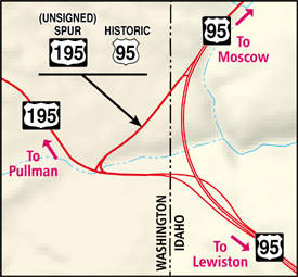 c. 1970's - present
At the top of the Lewiston Grade, US 195 splits off from US 95,
enters Washington, and runs along the eastern border of that state.
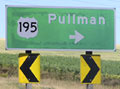
It serves another university town: Pullman, home of W.S.U. - or
"Wazoo", as the locals say. From there, it continues up to its
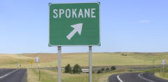
northern terminus in Spokane (see photos below).
Personally, I think it would be helpful to extend the US 195
designation south all the way into Lewiston: co-signed along with US
95 down the Grade, ending at the interchange with US 12
(incidentally, the yellow highlight on the first map above indicates
the route of US 12's predecessor, historic US 410). But currently,
the south end of 195 is at the southern edge of the Palouse, just shy
of where the prairie gives way to the Lewis-Clark Valley.
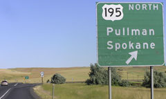
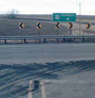
The signs in this first series of photos are along northbound US 95, at the
exit that marks the beginning of US 195 (traffic exits right, but as you can
see on the map above, it then crosses under US 95):
 Elbert,
July 2005
Elbert,
July 2005
In the background, you can see where the routes actually split; the shot below
was taken there:
 Elbert,
July 2005
Elbert,
July 2005
In the gore, there's another little reminder that you need to exit if you're
heading for Spokane:
 Elbert,
July 2005
Elbert,
July 2005
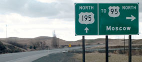
In the distance you can see the US 95 and US 195 reassurance markers; the one
on the left is shown close-up below:
 Elbert,
July 2005
Elbert,
July 2005
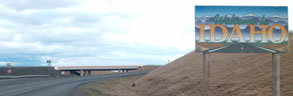
Ahead, you pass under the new US 95, into the state of Washington, and then
you find yourself on a short segment of historic US 95. When you come to the
road that carried the original US 95, it's now signed "To US 95":
 me, Mar. 2001
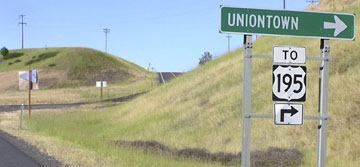
Straight ahead was the original south beginning of US 195 (it's a designated
scenic drive in Washington)...
 Elbert,
July 2005
Elbert,
July 2005
...but if you take that right turn onto old US 95, just after you cross back
into Idaho, you'll see the view shown below:
 SRweb
SRweb
That's looking north on "Spur US 195", or historic US 95. The semi is heading
north on modern US 95; you can see how the old route used to align with the
existing route ahead. The new US 95/US 195 junction is a partial interchange
(serving northbound-to-northbound and southbound-to-southbound only). So Spur
US 195 is still necessary to facilitate northbound-to-southbound and southbound-to-northbound
traffic. Heading the opposite direction (south on US 95), here's the view at
Spur 195:
 Elbert,
July 2005
Elbert,
July 2005
Today US 95 curves off to the left. But originally it continued ahead via the
road visible right in the center of the photo. Not far ahead from there, you
come to the T-junction shown below:
 me, Mar. 2001
That's looking at the south end of Spur US 195 at mainline US 195. This used
to be US 95, which turned left here. US 195 began to the right. Below is a close-up
of the sign:
 Elbert,
July 2005
Elbert,
July 2005
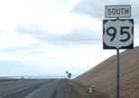
Now, we'll head south on US 195. The photo below shows the
historic south end of US 195. Southbound US 95 came in from the left
and then continued straight ahead:
 me, Mar. 2001
Now the US 195 designation is extended straight ahead to its
junction with modern US 95, in the vicinity of the overpass in the
background. A bit further ahead, we cross the Idaho line...
 me, Mar. 2001
...and then, without any other warning, we suddenly find that we're no longer
on US 195:
 me, Mar. 2001
There was no "End US 195" sign posted. Straight ahead is "the Grade" descending
into Lewiston. I think the US 195 designation should extend ahead, co-signed
with US 95 to the US 12 interchange in Lewiston. If you're interested in more
information on current and historic US routes in that city, please see my Lewiston
highways page.
Originally US 2 went only as far west as Bonners Ferry ID. So US 195 used to
continue north from Spokane (along what is now US 2); its north end was in Sandpoint
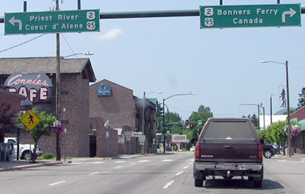
ID. There, US 95 came in on 1st Avenue, then west on Cedar Street, then north
via 5th Avenue. The shot below was taken looking west on Cedar:
 Elbert,
July 2008
Elbert,
July 2008
That's at the 4th Avenue intersection. Ahead, US 95 continues to the right
on 5th; to the left was once the north beginning of US 195. As US 2 does today,
US 195 turned west on Pine Street, then southwest on Dover Highway. You might
be wondering: if the shot above is from the perspective of someone already on
US 95, then why is US 95 signed both directions on 5th? Well, it's because the
arterials encircling downtown Sandpoint have been converted to one-ways, essentially
forming a giant rotary. Eastbound US 2 traffic coming in from Priest River can
no longer make a left turn on 5th. Instead, drivers have to continue east on
Pine, then join US 95 by heading north on 1st, then west on Cedar, then north
on 5th (which adds up to an extra eight blocks of travel). Likewise, northbound
US 95 traffic can no longer turn left onto Pine in order to connect with westbound
US 2. Instead they now have to follow the one-ways, so drivers wanting to make
that movement also end up at the junction shown above. So that overhead signage
is correct... although I think it would be more helpful if directional tabs
were included. But just ahead, the most common movement is re-emphasized on
an assembly that includes directionals:
 Elbert,
July 2008
Elbert,
July 2008
The shot below is looking south on 5th:
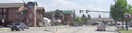 Elbert,
July 2008
Elbert,
July 2008
That's southbound US 95, which originally turned left on Cedar, while straight
ahead was the north beginning of US 195. In 1948, US 2 was extended west from
Bonners Ferry by joining US 95 south to Sandpoint, then US 195 south all the
way to Spokane (where the two routes split). In other words, the northernmost
76 miles of US 195 were duplexed with US 2. Since most of the Washington segment
was north-south in direction, it makes sense that WSDoT duplexed US 195 with
US 2 to the end of their jurisdiction (at Newport). However, since the entire
Idaho segment was essentially east-west, it's possible that at some point IDoT
stopped signing the north-south US 195 at all in their state, instead opting
to sign their portion simply as "East" or "West" on US 2
(some maps seem to indicate this). Whatever the factors, WSDoT eventually decided
that it was pointless to duplex US 195 north of Spokane, and in 1969 the designation
was truncated to that city.
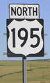
In Spokane, US 195 was originally routed on Inland Empire Way. However, by
the time the designation was truncated to Spokane, traffic had been rerouted
along the newer 4-lane that US 195 uses today. US 2 had been rerouted off Sunset
Boulevard, too, so the only place where US 195 has ever ended in Spokane is
the interchange where it still ends today: I-90's exit 279. There's no "End"
sign, but the shot below shows US 195's north end at its junction with I-90/US
2/US 395:
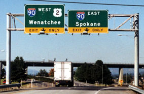 Taylor, 2000
The shot below shows the exit from eastbound I-90 onto the north beginning
of US 195...
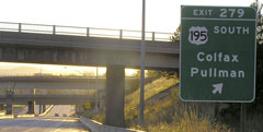 Elbert,
July 2005
Elbert,
July 2005
...and below is a view from westbound:
 Elbert,
July 2008
Elbert,
July 2008
I think the viaduct at right is for a railroad. If you take that exit, you'll
soon see the first southbound reassurance marker:
 Elbert,
July 2005
Elbert,
July 2005

Page created 09 October 1999; last updated 14 July 2008.
|