
|
|---|
On a well blazed trail, there's no need for a compass, or a GPS, and, on some trails, even a map isn't necessary. On a poorly blazed trail, for hiking long distances though, a GPS receiver is a convenient tool to use for navigation. It shouldn't be used as a primary tool for doing so. When navigating with just a map and compass, you must be aware of any magnetic declination offset, your pace over distance, be able to spot landmarks, both to keep on a heading, or to triangulate your position, be concerned about lateral drift. On a hike, use a GPS in conjunction with map and compass. For instance, use it to get your position, and the bearing to a next point. Then, set your compass to that reading, turn the GPS off, and go. As with a compass, GPS bearings are as the crow flies, ie, a straight line. If you deviate from that line, just punch up your position and bearing, reset the compass, and go again. Generally, a GPS unit allows the input of coordinates (called waypoints) in three ways, either latitude and longitude, or universal transverse macerator (UTM) and Grid.
Latitude and longitude coordinates are best to use for navigation covering long distances in a rapid manner (Pilots, air and sea, use this method). UTM coordinates are best to use for "on land" navigation. (Latitude and longitude provides no consistency of spacing, as the grid isn't perpendicular, as UTM is.) Latitude is read north and south of the equator, longitude is read east to west, a coordinate is in degrees, minutes and seconds. A UTM coordinate is based on a meter grid system, read from left to right (Easting, y axis), and bottom to top (Northing or Southing, x axis), in each of 60 zones. Grid: You can set the GPS, compass, and map all to the UTM grid. This way, all can be read as one unit.
GPS receivers are becoming more common in use with backpackers, as their prices drop.
" Hey," you say, "I know my map and compass skills, I don't really need a GPS." Probably, someone said, when the compass, or maps, were invented, "I know my stars and landmarks, don't need a paper drawing or a floating neddle."
A GPS receiver basically serves up all this navigation to you. It gives positions, bearings, distances, tracks, off couse indication, alititude, time, and a host of other features.
A GPS bearing will not get you to an exact point! The federal goverment has a built in transmit error (Selective Availability ( SA). The feds can turn the error on or off, and in the future it will be off. There's ways to compensate for the error, but it isn't necessary to while hiking. Usually, with that error, you can get within 100 meters of a position. Be aware also, makers of GPS units use different tables in the unit, to calculate magnetic declination (not transmitted), a table over time might be 1-2 degrees off.
Look at the examples below. Note: Map isn't to scale, the UTM grid is 10,000 meters (10 kilometres), as shown on most USFS maps.(USGS 7.5 minute maps are in 1000 meter squares, 1 kilometre). A GPS can be programed to give a reading for distance in kilometres or miles, so even though you get or enter waypoins in UTM metres, you still can use miles for distance. Direction can be magnetic, true, or grid course.
Note: For a GPS to return a correct coordinate, it's very important that you have entered the correct DATUM into the GPS, the datum a map is based on, (Example: 1927 North American (NAD27) usually printed on a Forest Service map!
At the bottom of the map are two 3 digit numbers, each having the 2nd and 3rd digits printed slightly larger than the first, the y-axis, increasing from left to right.
On the right, two 4 digit numbers, each having the 3rd and 4th digits printed slightly larger than the first two, the x-axis, increasing from bottom to top.
Read coordinates:
RIGHT (Easting)
UP (Northing)
5064373N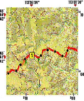
At the top of the map are longitude numbers. increasing from right to left.
On the left are the latitude numbers, increasing from bottom to top.
(Both in degrees, minutes, and seconds, as on a map).
Read coordinates:
LEFT (Longitude)
Therefore:
113` 56' 54"WHere's some WAYPOINTS I saved from a CDT hike.
There's a lot more information on the internet on GPS. In my Mailist section is a link to a GPS newsgroup, in the Maps and GPS section, many links to GPS related stuff. There's some links to find latitude and longitude points, software to convert those points to UTM.
Converting Latitude-Longitude Notations to Themselves
Some tables and internet sites return latitude and longitude in the notations below, and there might be a need to convert from one to the other, here's how. There're 60 minutes in a degree, and 60 seconds in a minute, therefore 60 is the mulipiler or divisor, to convert any notations.
Convert DD.DDDD to DD.MM.SSA position in whole degrees and a fractional part of degrees, conversion of it to degrees, minutes and seconds Multiply the FRACTIONAL part by 60 to get MINUTES and FRACTIONAL MINUTES: Next, multiply the FRACTIONAL MINUTES by 60 obtains the SECONDS:
| Convert DD.MM.SS to DD.DDDA position in degrees, minutes, seconds, conversion of it to degrees and fractions of a degree. Divide the SECONDS by 60, to get DECIMAL SECONDS: Next, divide the WHOLE MINUTES and DECIMAL SECONDS by 60 obtains the fractional part of degrees: Therefore: 48 30' 7.2"= 48.5020 DD.DDDD |
When you're finished with this section, |