
IRISH LOOP | ACCOMMODATIONS | TOURS | HOLYROOD | MAPS OF NEWFOUNDLAND | FREE MAPS
A tour of the Cape Shore will take you to the Cape St. Marys Ecological Reserve seabird sanctuary, one of the most incredible wildlife spectacles in the world, and into a part of Placentia Bay that played an exciting part in the history of North America during its early days when England fought France for control of the colony and the continent.
Start at the intersection of Route 1 and Route 90. You will pass by the Salmonier nature Park, part of the Irish Loop, and then proceed to Colinet. Colinet was probably named for one Andre Colenet, master of the French fishing vessel Le Montaran. As early as 1723, John Masters and his partner Phillip Watson had fishing premises at Colinet in the inner reaches of St. Marys Bay.
 |
 |
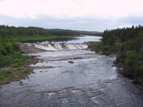
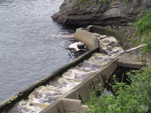
From Colinet take Route 91 to see Atlantic Salmon scale the man-made salmon ladder on the Rocky River Falls. Learn more about salmon enhancement by taking a guided tour. Proceed along to Cataracts Provincial Park. This picnic park is built around a deep river gorge with two cascading waterfalls which are accessible by a system of walkways. The interesting natural scenery attracted Newfoundlands first motoring tourist in the 1920s and still holds a fascination for visitors today.
Route 92 goes south to Branch, the start of the Cape Shore. This part of the coast was first settled by Irishmen with names like Nash, McGrath, Careen, Coffey, Doyle, and Power who settled here to escape the famine and oppression in Ireland. Those surnames are familiar here today among descendants of the original settlers. Not much has changed here since then. Its still a wonderland of rivers, lakes and silent hills and, barrens. Along the Cape Shore you will find grazing sheep, brightly colored houses, old churches and winding lanes, and an Irish air.
As the residents say themselves, dont look for glitz here. Life is more personal. Drop in and chat over a cup of tea and learn the history of the area, how Irish settlers were lured here with the promise of a new beginning, or how Solo the peddler made a fortune from a wrecked cargo of cotton thread. And of course this being Irish country, there is a gold story. Legend has it that a man named Andy Nash stumbled across a vein of gold while crossing the barrens on a foggy day and could never find it again. There is also a tale of buried treasure that supposedly lies in some long forgotten nook, just waiting for an enterprising soul to come along and find it.
 |
 |
The hospitality here is warm and genuine, and is what keeps visitors coming back. The language here is unique, and the music will break your heart and mend it again in one song. Get out and roam the countryside. There are many places well worth finding, at the top of a hill or along a sandy shore. Pick partridge berries in late summer, or photograph a moose as it grazes by the roadside.
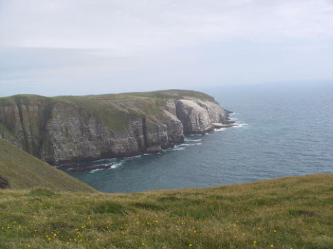
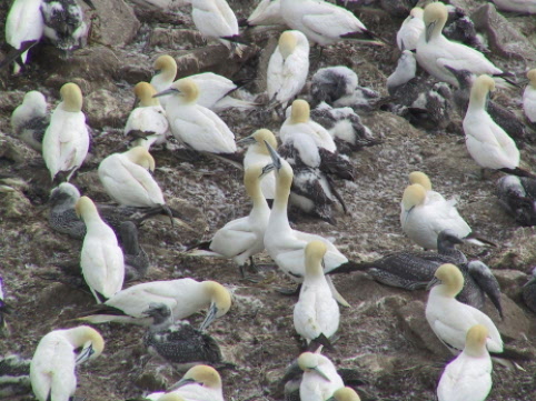
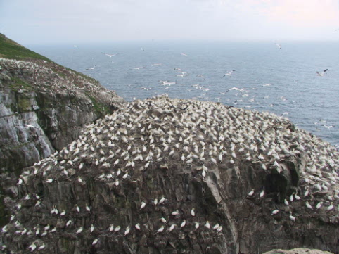
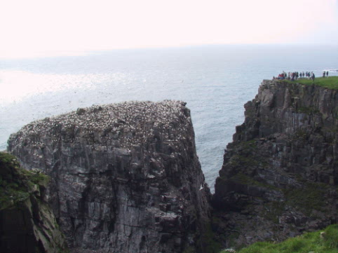
At the end of a road west of Branch is Point Lance, which has a fine beach. Back on Route 100, drive to the junction of the road leading to the Cape St.Marys Ecological Reserve. It is marked by a sign. The 12.6 km road leads to a view immortalized in the Newfoundland folk song Let Me Fish off Cape St.Marys. The vantage point, a 15-30 minute walk from the interpretation center, overlooks Bird Rock, the third largest nesting site for gannets in North America, and offers a spectacular opportunity to photograph these gorgeous, golden headed birds with the two metre wing span. This is also a nursery for thousands of murres and kittiwakes. During the summer months the cliffs are alive with seabirds.
 |
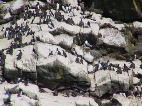 |
The sanctuary at Cape St.Marys may be visited year round and no permit is necessary. In the summer, the new interpretation centre is open and there are guides to answer your questions and to show you around. You can see Bird Rock through a huge window or through telescopes and there are displays on the ecology and wildlife of the cape.
 |
 |
Follow Route 100 to St. Brides. Irish roots are strong here and traditional song, dance, and recitation have survived. Exciting traditional performers from the Cape Shore, as this stretch of coast is known, now take their music to folk festivals throughout the province. Nearby Cuslett is located in one of the many coastal valleys.
The next community is Angels Cove, where there is great swimming at Angels Cove Falls. This stretch of the Cape Shore was settled in the early 1800s by Irish settlers working for the Placentia merchant firm of Sweetmans. Angels Cove is unusual because it is one of the few communities in Newfoundland originally settled as a farming venture. At Gooseberry Cove Provincial Park you can watch the waves roll onto a long sandy beach or hike among the unusual purple rock formations that frame the cove. The grassy backshore is an ideal place for a picnic before you go on to explore Little Barasway, which take their names from the Newfoundland term for barachois- a sandy isthmus providing shelter for exposed harbours.
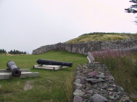
Past Point Verde you come to Placentia, a community situated on a large beach near a coastal forest area. In the early days of the 17th century this was the French capital of Newfoundland. Colonial French land and sea forces, aware of its strategic location, established a fortified base on a summit overlooking the ocean arms of Plaisance, as the French called it, in 1662. On the commanding site of what is now Castle Hill National Historic Park, the French erected a fortification called Le Gaillardin in 1692, a year of intensive English campaigns. The following year Fort Royal was begun as the main defence against the English attacks by sea. The area adjacent to the park, at the northern point of Placentia Gut and east of the town, were previously defended by Fort Louis and Fort Le Vieux, both of which have long since surrendered to the elements. From their fortified position at Placentia, the French attacked the English capital of St. Johns three times. Each time they were forced to retreat, but only after they had captured the main fort twice and burnt the city down.
The British moved into Placentia after the Treaty of Utrecht in 1713. During the seven years war its defences were upgraded to help in the recapture of St. Johns, which just months previously had been taken by the French. With British supremacy assured, Placentia was soon outranked by St. Johns which became the capital of the colony. Today visitors can stroll along the stabilized ruins on Castle Hill and enjoy the spectacular view of Placentia Bay. In keeping with the military nature of the site, the Interpretation center is built into the hill like a bunker. The displays inside tell the story of the ordinary soldiers and fishermen who toiled here in times past. The hiking trails at the site pass through stands of evergreen trees that fill the air with a pleasant scent.
 |
 |
In the town of Placentia, you find the community museum in OReilly Heritage House on the waterfront. This grand old house has a fine collection of period furniture and some unusual woodwork. The town also features an old church with a stone presbytery, and a government services building with a fine clock from earlier this century.
From Placentia, it is a short trip to Argentia Ferry terminal which operates between Argentia Newfoundland and North Sydney, Nova Scotia during the summer. Argentias importance lay in its strategic position and its ice free harbour. In 1940, the United States Military began construction of a Naval Operating Base and Air Station which served the American and other Allied Forces during the war years. The base closed in the early 1990s.
A conference between U.S President Franklin D. Roosevelt and Englands Prime Minister Winston S. Churchill was held at sea off Ship Harbour in 1941. It resulted in the Atlantic Charter, which laid out a vision for the post war world during a very dark period. A monument marking this meeting which is some times referred to as the First Summit, has been established at the end of a road off Route 102 amid the splendid scenery of Placentia Bay.
Take Route 100 through Dunville and back to Route 1 where the Cape Shore Drive ends.
| Mount Carmel | Colinet | North Harbour |
| Branch | Cape St. Mary's | St. Bride's |
| Placentia | Cape Shore Web Site | Whitbourne |
CAPE SPEAR | ACCOMMODATIONS | TOURS | HOLYROOD | MAPS OF NEWFOUNDLAND | FREE MAPS
|
|
|---|
| This Atlantic Canada Webring site is owned by The Cape Shore Want To Join The Webring? [ Prev 5] [ Skip Prev] [ Prev] [ Next ] [ Skip Next] [ Next 5] [ Random] [ List Sites] |