
The Atlantis Trail...
updated article 15 Jan 2007
by Jim Allen, author "Atlantis: the Andes Solution", Cambridge, England
THE great curiosity of Plato's description of Atlantis (the fabulous city which he said sank into the sea in a single day and night) is that firstly the geographic description of the region he called Atlantis exactly matches the Bolivian Altiplano - "a level rectangular plain in the centre of the continent and midway along its longest side" and secondly, that the sought after site where he said the city was - a circular island enclosed by rings of land and sea pretty well matches the ringed formation at Pampa Aullagas - exactly where he said the city should be - "in the centre of the Plain, 50 stades (5 miles) from the sea."
Locating the site was not an easy task, especially when operating from a country (England) on the other side of the world, and at a time (1978) when very little information was available about Bolivia and the Internet was not yet the great source of information it has become today.
Indeed, it was difficult to find even when the rainy season was in Bolivia due to conflicting reports, but at that time, excellent mapping had become available based upon satellite photography so when Plato said the region all round the city of Atlantis was "a smooth and level plain, rectangular in shape and high above the level of the Ocean sea," I searched all of the Americas for such a smooth rectangular plain and thus it was that I found the Altiplano, but
it's rectangular shape only became truly apparant when I decided to build a three dimensional topographical model, cutting out the contours layer by layer; when I cut out the 13,000ft contour the rectangular shape revealed itself and then it was that I knew that I had found the rectangular plain of Atlantis.
I acquired different translations of Plato's text, and the one by Sir Desmond Lee included in a small footnote the important information that the rectangular plain was also "midway along the longest side of the island (continent)" thus further confirming the Altipano as the location.
There were numerous other small and important details and these have been added to over the years as more information has become available, but here following are the basic reasons why this region is identified as the source of Plato's wonderful story of Atlantis.....

The continent of Atlantis from map by 18th century cartographer,Guillermo Sanson

The Atlantis Trail
And so it was in 1995 that I made my first trip to Bolivia with the intention of locating on the ground this feature which I had seen on the satellite photos and which resembled a section of the giant canal, hoping this would be a sufficient proof to interest others to take the investigation further.
This canal 1 stade (600ft) wide which Plato said ran right around the perimeter of
the plain and discharged into the sea (lake) would be perfectly
possible on the rectangular Altiplano following the 12,000ft contour on the
plain and the satellite images showed a possible section to the north-west of
lake running for about a distance of 9 miles.
 Aymara woman spinning wool with the canal in the background.
When I first visited it in 1995, it was immensely wide, as Plato
said "it is incredible to believe that it should be as wide as the account
states, but we must report what we heard." When I revisited the site in April of
1998 with a film crew and also in the company of the Kota Mama expedition led by
Col John Blashford-Snell, their opinion was that it was a fault line and it was
marked as such on the local geological maps. However a year later I had the
opportunity to interview the general secretary of the
Institute of Geology in Cochabamba who was well familiar with the area and
examining the aerial photos of the feature he stated most definitely that it was
a canal and not a fault line.
 Looking into the canal with water in the base
The section I visited had a flat base and sloping sides, even
in the height of the dry season it carried water and the locals watered their
flocks there. The pools of water which apeared in the base even in the dry season turned out to be fed by underground springs, whether canal or natural feature, it still served the purpose of providing water for the local animals and a number of these pools and natural watercourses exist all over the Altiplano which could all be joined up to divert the precious water to other regions.
FILM PRODUCERS like lost cities. But a lost city which may lie
beneath the ground or beneath the waters of a lake large enough to be an inland
sea is of little use to them as producers also like ruins. Ruins that can be
filmed and also interesting local characters to put in the film.
Thus it was that in December of 1998 on my third trip to Bolivia I came to the lost city or "enchanted" city or
"petrified" city as it is sometimes called of Pumiri on the northern edge of the
rectangular plain known as the Bolivian Altiplano.
I had come here with a film producer and his researcher on a
recce in advance of a proposed film about Atlantis which would also feature
largely my theory and discovery that Plato's geographical description of the
lost continent of Atlantis exactly fitted the continent we presently call
South America.

Starting point for any expedition is the large mining town of
Oruro, itself former capital of the ancient Uru peoples and now folklore capital
of Bolivia famous for its carnival of the devil. People from all over the
country gather here for the immense procession of music and dancing with
outlandish devil costumes, the devil being the patron of the mines in Bolivia.
The ancient mine in Oruro whose entrance is to be found inside the church
is also definitely worth a visit, said to have been excavated long before the
arrival of the Spanish or even Inca times.
From Oruro the route heads south-west along the road to Chile,
passing through Toledo and turning off somewhere near Corque on the road to
Andamarca. After some six or seven miles it is then necessary to turn off this
road and head east into the bush, if necessary leaving the vehicle to walk a
short way on foot until one comes across the site of the canal. A GPS is
advisable for the whole trip and the most convenient map is the 1/500,000 air
navigation chart available in advance from Stanfords of Long Acre, London. The
canal is clearly marked on it as a ribbon of water and named on the 1/50,000
Bolivian maps as Laguna Janko Kkota.
The Atlantis Trail then turns northwards to Volcan Columna, a circular
ring of land in the north centre of the level plain. I came within about six
miles of it on my April 1998 expedition and in the distance it looked like a
broad, flat topped mound. It scaled three miles in diameter from the aerial
photos, comparable to the "mountain which was low on all sides" as Plato called
it, however it was only a single ring of land whereas Plato said that two rings
of land and three of sea originally surrounded the central island of the
Atlantis complex. A nearby mining engineer said it was formed by the explosion
of a gas bubble and this was the material which fell back to earth. The centre
contains a small lake and the site proves that rings of land similar to Plato’s
description are possible on the Altiplano.
A few miles north of Volcan Columna and about 20 miles west of
the village of Turco lies the mysterious city of Pumiri, hidden amongst
spectacular rock formations weathered into jaguars, pumas, condor-like shapes
etc. The site covers some 20kms of cliff-like rocks on the edge of a dried-up
river bed and conceals ruins of perhaps three different civilisations.
Discovered by one of the locals at Turco its location was only revealed by the
finder to his son on his death bed and remains one of the least explored sites
in Bolivia or the world.


arriving at
Pumiri
We arrived just as dusk was falling. A time-frozen condor and puma
looked down on us from the petrified stone as we parked the jeep and gazed out
dumbstruck at this most awesome of landscapes.
Well, no, we weren't really thinking of spending the night
there, in a place haunted through aeons of time and returned next day for a further exploration of the site.


ruined walls and overlooking
the plain from Pumiri
From Pumiri strike westwards in the direction of Sajama,
considered the highest volcano in Bolivia and this snow stopped mountain, haven
for climbers, acts like a navigational beacon for travellers all over the
Altiplano since its gleaming white cone can be easily recognised from great
distances. Revered locally as Pacha Mama mother earth and spiritual home of
the Uru it is now the centre of a national park patrolled by wardens and can
also be approached via a new metalled highway running directly from La Paz. But
instead of heading right into Sajama country, follow the road around the edge of
the rectangular plain towards Volcan Quemado (the burnt volcano) and pass the
night at the village of Sacabaya one of the most beautiful locations on the
entire plain.

thermal pool at volcan Sajama

Volcan Quemado


view inside Volcan Quemado with Volcan Sajama in the distance
A whole day is needed to climb and explore Volcan Quemado, the
climb itself could take 1 - 2 hours and the secret of the volcano is that its
interior contains an "island" or cone inside a crater which is in turn contained
within an outer crater an arrangement similar to Plato’s ringed city. Quemado
is also on the active side of the Andes and activity last took place some two or
three thousand years ago when a new cone arose and grafted itself onto the
northern face of the existing cone. Anyone living there would have had a hot
time of it and the inner site is littered with huge shattered stones ejected by
the volcano.
From Volcan Quemado the Atlantis Trail follows the edge of the Plain past Bella
Vista to Sabaya. Here I met a couple of cyclists proposing to cross the Salar de
Coipasa and asked them to keep a lookout for any signs of a vast canal on the
western edge of the plain near Llica since the geology map shows a route formerly linking the two salars and running through Llica although now lifted by geological action to be some height above the level of the plain. A letter arrived six weeks later in
England saying they saw cuttings and had reports of remains of a canal not at
Llica but a few miles to the east at Tres Cruces, so this still remains to be checked out one day by a site visit.

From Sabaya it is worth to detour around the Salar de Coipasa
to the village of Chipaya where the beehive huts of the Uru/Chipaya peoples are
to be found, some say these are the oldest inhabitants of South America and
their own legend says they are the people of the dawn, "the first people to
emerge after the darkness". Formerly they lived on floating islands on Lakes
Titicaca and Poopo and along the connecting River Desaguadero, their territory
being known as "Umasuyo" the kingdom of water.
From Chipaya the route heads along the edge of the salar
towards Llica, passing through the connecting channel between Salar de Coipasa
and Salar de Uyuni to Garcia Mendoza, a former stronghold of the Urus in the
shadow of the towering Volcan Thunapa and on the edge of the glaring white
expanse of salar.
Before visiting the next volcano at Santuario de Quillacas, the
route passes an impressive meteorite crater about two miles wide.
Santuario de Quillacas is a perfectly circular gently sloping volcanic cone exactly
the diameter (2.1 miles) Plato gave for the city rings of land and when the sea
floods it becomes an island surrounded by a ring of water. The site even contains
a village on a mound in the centre, flanked by two volcanic peaks one to the
north and one to the south, possibly remains of a circular central crater
destroyed sometime in the past.

The site also contains red and black stones such as Plato
mentioned and these have even been built into a pattern on the piers of the
church similar again to the variegated pattern of red and black stones Plato
said adorned the buildings of Atlantis. The village is supplied by water from an
underground spring.

red and black stone patterns at church in Quillacas


the famous mummies of Alcaya, a little known citadel on the Atlantis Trail near Salinas Garcia Mendoza
But it is a nearby site called Pampa Aullagas which corresponds most closely to the location
 Plato gave for the missing city of Atlantis, being in the centre lengthways of
the plain yet 50 stades (5 miles) from the edge of the sea (Lake Poopo).
Plato gave for the missing city of Atlantis, being in the centre lengthways of
the plain yet 50 stades (5 miles) from the edge of the sea (Lake Poopo).
In September of 1999 I made my fourth expedition this time to the site at Santuario de Quillacas as a guest of Carlos Aliaga of Cochabamba and in the distance we saw the mysterious looking site of Pampa Aullagas. In May of the following year, Carlos visited the site in the company of his wife Anna and two boys and reported that the site had a ring wall of stones, including red, black and white stone, as well as circular canal-like formations or sandy depressions. The name "Aullagas" also in Aymara meant the same as "Desaguadero" or drain or another interpretation might mean "sunken" or "the place that is no more."
The site then, has the same name as the Bolivian legend of a sunken city, part of the site is actually sunk by earthquakes, it has circular sandy canals and the region around the site is subject to floods being where two rivers, Laca Jahuira and Marquez discharge into Lake Poopo. To prevent flooding, a circular wall could be built at the sea and continue in a circle around the
site since this is what existed at the original city If one makes the climb to the top of
the peak it is easy to see how the city could have existed as an ideal
route centre on the level plain and approached by a canal from the sea which is
seen a few miles away in the distance. Thus materials could have been brought
here by boat from far away Lake Titicaca and along the Desaguadero River to Lake
Poopo, then (after transhipment) along the valley of the Rio Aquas Calientes (river of
hot waters) which becomes the headwaters of the Pilcomayo river, passing the
famous silver mountain at Potosi and thence to the river Parana and the
ocean.
It took five expeditions on site following
The Atlantis
Trail
to find this location which I visited in December of 2000 in the company of Lisa Hutchison making a film "Atlantis in the Andes" for Discovery Channel. This site is presently called
Pampa Aullagas
which is the name of the village and region and the mountain itself is called Cerro Santos Villca
at the southern end of Lake Poopo.
 Atlantis as an island

In the wet season, Pampa Aullagas becomes an island
As to the perfectly circular canals we had imagined based on popular drawngs,
I looked up Platos words again and he said in the beginning..... "Near the plain
at a distance of 50 stades (from the sea) there stood a mountain that was low on
all sides. And Poseidon, to make the hill impregnable broke it off all round
about; and he made circular belts of sea and land enclosing one another
alternately, some greater, some smaller, two being of land and three of sea,
which he carved as it were out of the midst of the island." Critias 108E-121C
(the Jowett translation reads
"Poseidon ....breaking the ground enclosed the hill
all round, making alternate zones of sea and land
larger and smaller, encircling one another")
And that was what we found, except that the sea had dropped and the "zones of
sea" were now sandy bottomed depressions.


rings of land at Pampa Aullagas
 Atlantis harbours classical illustration
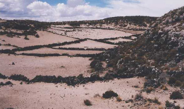

views of former "belts of sea"

sandy deposits in canal-like depressions show former inner and middle
belts of sea.
"There were three rings of water and two of land"

middle canal on south east side

Inner canal on the northern side.
So here is a site that has all the factors that Plato mentioned, firstly it
is in the centre of the level rectangular plain at a distance of 50 stades from
the sea. It has the required red, black and white stone. It has underground hot
and cold springs. It is a route centre at the southern end of the lake.
The locals report that part of the original site was destroyed in "el gran diluvio"
- the Great Flood. The lake was also formerly called Lake Aullagas.
Pampa Aullagas is also said to be home of the water god Tunapa - the equivalent of the Greek god Poseidon and according to Bolivian legend Tunapa married a local girl and subsequently created the ringed formation at Pampa Aullagas - surely the origins of Plato's Atlantis story of Poseidon marrying Cleito and "breaking the hill off all round about......"
But most remarkable of all, the site has been sunk by earthquakes and a Bolivian legend called
 "The
Legend of the Desaguadero"
tells of a city on the edge of a lake, punished by
the gods and submerged by the sea, in exactly the same manner as Plato's
Atlantis. So there can be no doubt that the story of Atlantis had it's origins in
in a Bolivian legend.
"The
Legend of the Desaguadero"
tells of a city on the edge of a lake, punished by
the gods and submerged by the sea, in exactly the same manner as Plato's
Atlantis. So there can be no doubt that the story of Atlantis had it's origins in
in a Bolivian legend.

Artists's impression "Atlantis on the Altiplano" by Lee Smart

remains of Atlantis,
"the mountain that was low on all sides." The part facing the camera has been
sunk by earthquakes. The water level was formerly just below the rim of the
flat, land circle seen on the right.
Returning by road along the eastern side of the lake hot and
cold springs such as Plato described can be seen at Poopo village, also at Pazna
where there is even a modern swimming pool supplied by thermal waters, - just as
Plato said, they even had hot baths for the women!.
Quillacas may be considered Bolivia's challenge to Thera and Pampa Aullagas certainly dismisses the notion that Atlantis was ever in Thera or underneath
the Atlantic Ocean when all the features Plato described are found here on the
rectangular Altiplano and nowhere else in the world. As a Newcastle professor
once put it on a radio interview, "if a site is to be considered as Atlantis,
then it must at least correspond to the things that Plato said." Here then is
Bolivia's challenge not only to Thera but to the world, if you want to see what
Atlantis really was like then come and see for yourselves.

The outside of the rings and the main site are covered in a wall of stone.

descending from the peak

November
2004 expedition Oruro Technical University Catedra UNESCO


stones from the site at Pampa Aullagas
Dating of Atlantis has always been a problem since Plato gave a date "9,000 years" before the beginning of the story as told by an Egyptian priest to Solon, around say 600BC. Plato also talks of a war between the peoples of Atlantis and the peoples of ancient Greece and Egypt and if we use a lunar calendar and substitute "months" for "years" then this would bring the date to around 1200BC which is the date of the Trojan War which was followed by the invasion of Egypt by the "Sea Peoples" so these may be the events underlying this part of the story.
Some people until recently said there was no early civilisation in the Americas but recent discoveries include pyramids at Caral in Peru which date to 2627BC, preceeding those of Egypt, mummies at Arica said to be 8,000 years old and the discovery of a large bowl in Bolivia called the Fuente Magna and covered in proto-Sumerian writing.
 Cuneiform Writing
on a bowl found in Bolivia, which has been named the "Fuente Magna" or "Rosetta Stone of the Americas", the archaeological picture of Ancient South America has now changed.
 The Fuente Magna
question - did the Sumerians sail to South America, or put the other way round, - did the Sumerians themselves come from South America?
The Fuente Magna
question - did the Sumerians sail to South America, or put the other way round, - did the Sumerians themselves come from South America?
Other similarities between Sumerian and early Bolivian culture.

 In his book "Legend - the Genesis of Civilisation", archaeologist David Rohl proposes that the ancient Egyptian culture was founded by Sumerians who landed on the shores of the Red Sea. He shows pictures of early reed ships painted on cave walls in the Eastern Egyptian Desert. What he does not mention or consider, is
that these reed ships painted on the cave walls are identical to reed ships in Bolivia - see photo with sample from museum in Bolivia.
Up to now, the main objection to Atlantis being situated in Bolivia is that it is said that there was no civilisation in Bolivia before, say, 1200BC. It was also said that no writing existed in ancient South America.
However the recent discovery of the city of Caral in Peru, with pyramids dated to 2627BC predates Egyptian pyramids.
The discovery of mummies at Arica in Chile date to 8,000BC - older than Egyptian mummies.
And now, Fuente Magna, a bowl inscribed with cuneiform, proto Sumerian writing dating to 3,500BC has been found in Bolivia. It also demonstrates
there was writing
in ancient South America. Could these "proto Sumerians" be the missing "Atlantean" culture J.M.Allen has been looking for?
Traces of coca have been found in Egyptian mummies, and coca has also been found growing on the island of Madagascar which would have been on the above route. On the island of Bahrain, Heyerdahl found interlocking stones of Andean-type construction at the lower levels of walls under excavation.


It is clear that civilisation in ancient South America is much older and more extensive than has been previously recognised. Due to lack of funding many sites have not been at all investigated and those that have, only partially explored. It is now acknowledged that a civilisation existed throughout the whole of Amazonia where previously it was thought there was none.
The dating of the Fuente Magna bowl pushes the origins of South American civilisation back to contemporary with or
earlier than Egyptian or Sumerian civilisation and other recent finds have not yet been published which may show that it is earlier still. There remains much to be uncovered or discovered and the Fuente Magna bowl is about to open a whole new chapter in the history of Bolivia, South America or Atlantis as it was once called, and the world.

J.M.Allen with one of the stone blocks
covered in fossilised lake sediments
found by team LAMA at Pampa Aullagas


webmaster: webatlantis@hotmail.com
main website JIM ALLEN’S
HISTORIC ATLANTIS IN BOLIVIA


 Atlantis as an island


 Atlantis harbours classical illustration


 "The
Legend of the Desaguadero"
"The
Legend of the Desaguadero" 


 Cuneiform Writing
 The Fuente Magna
question - did the Sumerians sail to South America, or put the other way round, - did the Sumerians themselves come from South America?
The Fuente Magna
question - did the Sumerians sail to South America, or put the other way round, - did the Sumerians themselves come from South America?
 In his book "Legend - the Genesis of Civilisation", archaeologist David Rohl proposes that the ancient Egyptian culture was founded by Sumerians who landed on the shores of the Red Sea. He shows pictures of early reed ships painted on cave walls in the Eastern Egyptian Desert. What he does not mention or consider, is


