
| Click here for homepage! | íslenska útgáfan er hér! |
| This trip was arranged by Ferdafelag Islands. The group stayed in a sleeping bag accomodation at Hrollaugsstadir in the Sudursveit region but from there we made daytrips. Due to an accident on the second day en route to Innri-Vedurardalur valley we had to abandon the daytrip but we tried again on the fourth day and then we were successful. The weather was fine the first two days but it rained on the third day. The weather was again fine on the fourth day. |
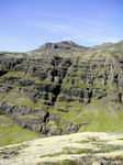
This was a short afternoon hike up to Fallastakkanof cliff which is made of 90 meter high basalt pillars.


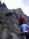
The trip started in good weather. First we crossed the Fellsa river and then we hiked up along the Mjosundaa river. When we passed Mt. Holmafjall then the Gabbrodalur valley opened with Fellsarjokull glacier furthest away. Midway into the valley we climbed up a gulley in Mt. Eystra-Midfell. The gulley proved more difficult than it had been the year before due to less snow this time around. Near the top of the gulley one of the group had some problems with loose rocks. Johannes the guide was quick to react and managed to break her fall but broke his arm while doing so. He remained calm despite the accident but of course the daytrip had to be abandoned.


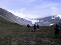


Walter the guide made another attempt with a part of the group to go to Innri-Vedurardalur valley. This time we took a more easterly route up to Mt. Eystra-Midfell which proved a good route. The route was along the side of Mt. Eystra-Midfell until we came up to a glacier north of Mt. Hvitingsdalstindur. After another half hour a great view over Innri-Vedurardalur valley opened. Then we walked in the snow north up and around crevasses in the glacier until we came down to Sveinatunga hill. On the way I managed to stick one foot down through the snow into a hidden crevice. The other foot had solid ice underneath so there was no danger. The crevice which I penetrated was seen on the surface as a hairline crack in the snow but underneath was a meter wide and at least 10m deep crevice. When we came down to the Sveinatunga hill then we could best see the contrasts in the green Mavatorfa grassland, the spectacular rhyolite mountains, the glacial lagoon and the glacier further away. This is one of the most remote places in Iceland and to me one of the most beatiful (the pictures don't do it justice). On the way back we hiked down along the Fellsa river and stopped by a waterfall.


It rained a bit this day especially the first part. We hiked from Innstabotnsgil gulley and to the bottom of Kalfafellsdalur valley. Along the way are many dark and inaccessible gulleys on the nort-east side of the valley but no large rivers are along the route. Innermost in the valley the Brokarjokull glacier falls steeply to the lowlands.


