
| Click here for homepage! | Íslenska útgáfan er hér! |
| I organized this trip by myself. This is one of the most popular hiking routes in Iceland and in high season (July) it can be difficult to get accomodation in the huts (owned by Ferdafelag Islands) unless one travels with a tour operator or books well in advance. Bustrips to Landmannalaugar and Thorsmork are frequent in peak season in summer after the highland roads have been opened. The campsites along the route aren't bad except maybe at Hrafntinnusker (sandy/rocky surface). The weather was bad the first day, decent the second and good the two last days. |
The route from Landmannalaugar (600m) to Hrafntinnusker (1000m) is short but very colourful. Regrettably, due to heavy rain, no photos were taken this day.
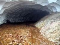
At Hrafntinnusker there is a hut. The campsite is free of vegetation which is not surprising since it was covered by glacier not long ago. I first hiked up to Mt. Hrafntinnusker and then down the southwestern slopes towards snowtunnels made by geothermal heat. The icecaves lie further north. The name Hrafntinnusker can be roughly translated as the mountain (sker) which penetrates a glacier and is made of obsidian (hrafntinnu). The glacier has receded but shiny black obsidian stones cover the mountain. Later that day I hiked from the campsite at Hrafntinnusker towards Lake Alftavatn. The view from the Kaldaklofsfjoll mountains was wonderful.


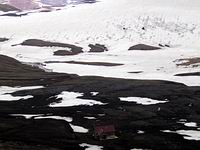


At Lake Alftavatn (550m) there are two huts and a good campsite. The route from Lake Alftavatn towards Botnar in Emstrur first lies over a few hills southeast of Lake Alftavatn. It proved easy to ford the Bratthalskvisl and Blafjallakvisl rivers. The Kaldaklofskvisl river has a bridge. The route across the sand deserts would be monotonous if not for the green tuff mountains (such as Mt. Storasula, Mt. Hattafell, Mt. Storkonufell...) which contrast sharply with the black sand. Innri-Emstrua river runs in a gulley which lies inside a shallow but very wide canyon. The river created the canyon in cataclysmic floods a long time ago. The huts in Botnar in Emstrur (500m) are ideally situated next to springs where there is also room for a small campsite.

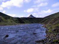


First I hiked up along the Fremri-Emstrua river until I reached a nice footbridge. Then the route lies downwards first along the Fremri-Emstrua river and then the Markarfljot river. As Thorsmork drew closer a small glacial river, named Thronga, had to be crossed. After that the paths lie in woodland (birch) until the final destination, Husadalur valley in Thorsmork (200m), was reached.


