|
Stories From Grand Canyon National Park
|
- PART ONE A - FOR A TRIP DOWN THE HERMIT TRAIL |
DRIPPING SPRING AND THE BOUCHER TRAIL
BY GEORGE WHARTON JAMES (1910)
From the head of the Boucher trail, it is a little over a mile to Dripping Spring, which is at about five thousand four hundred and ninety-three feet elevation.
The trail descends easily at first through a beautiful wooded canyoncito, where it is completely hidden and embowered in foliage. Then it winds its way down and around the cherry limestone, to the top of the cross-bedded sandstone, down which zigzags and steps lead one to the spring itself. This is located in a picturesque spot.
|
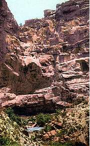
DRIPPING SPRING From the rocks above, with a drop of about fifteen feet, seeping through a green cluster of maidenhair ferns, the pure water of the spring drips into a stone trough placed to receive it. Day and night, winter and summer, fair weather or foul, it seldom varies its quick, tinkling, merry drip, drip into the receptacle below. Below the trough, a natural cavity in the rocks receives the overflow, and here, within the pool and on its edges, aquatic and other plants grow in profusion, while some recently acquired goldfish swim to and fro among beds of moss and floating lilies. |
 |
Photographs of Boucher
and His Camp at Dripping Spring
 |
HERMIT BASIN Here, after lunch, one continues on his trail trip to the river. For three miles the trail winds in and out of the recesses, on the easily rolling ground of the plateau. There are no sharp descents. For about half a mile the trail is in Dripping Spring Amphitheatre, an alcove on the edge of Hermit Basin, so named by Louis P. Brown, a miner and prospector, who, in the early eighties, made this basin his home while engaged in prospecting operations in the Canyon. |
Two miles out, one sees the continuation of one arm of the Bright Angel fault
in the shattered strata of the red sandstones, some masses of which are toppled over at the base of Pima Point.
It was this fault that made the talus slopes, down which the Boucher Trail descends, and also the great eroded
recess of Hermit Basin.
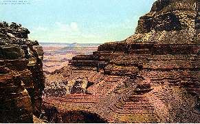
COLUMBUS POINT
The nose of the plateau on which we have been travelling, now directly under Yuma Point, is named Columbus Point, and from this spot, where several noted American painters have made paintings destined to become memorable, the outlook in three directions, east, west, and north, forms one of the noblest of all the panoramas of the Canyon my eye has ever rested upon. Shiva's Temple is almost directly opposite, as we look towards the northeast. Stretches of river are exposed east and west, where raging rapids send up their roar to us. Overhead is a great castellated structure, surmounted by a lesser building, with round tower, embattlements and all the architectural accompaniments of an elaborately equipped castle of ancient Europe.
To attempt to describe all the objects seen in the heart of the Canyon is needless.
Suffice it to say that the panorama takes in every tower, temple, butte and structure, seen from Point Sublime
on the north side; or any of the points on the south side, from Havasupai Point on the east, to Yavapai Point on
the west; and includes Wotan's Throne, Vishnu Temple, and the Wall of the Little Colorado to the far-away east.
ON THE LOWER TRAIL TO THE RIVER
The trail then winds under Yuma Point, and zigzags down the thinner strata of the red sandstones on to the red-wall limestones, where it affords more extended views on a lower plateau of lesser area, the rocky butte on the end of which is named Bunker Hill Monument.
From this plateau another rapid descent is made through masses of rock to the bed of Long (or, Boucher) Creek, where, at the distance of about a mile from the river, is located the lower camp. Here Boucher has planted a garden of all kinds of vegetables, and with seventy five trees, which include oranges, figs, peaches, pears, apricots, apples, nectarines, and pomegranates; he boasts of his melons, canteloupes, beets, onions, tomatoes, chile, carrots, cucumbers, parsnips, etc., and I can vouch for the sweet and refreshing qualities of his melons. Tomatoes, ripe and green, covered his vines in January, and he has them throughout the year. It needs no comment to explain how delightful fresh vegetables are, after one has made this trail trip, especially if it should be in the hot summer months.
A Panoramic Photograph of Boucher Basin and Camp
Good and comfortable beds and other camp accommodations are provided here, so that a stop may be made over night. In the morning, the river is visited, and the return trip accomplished in easy time for dinner. The distance from rim to river has not been measured, but it is estimated to be from eight to ten miles.
As to fishing, Louis Boucher caught and took to El Tovar a silver salmon, two feet eight inches in length, sixteen inches in circumference, and weighing eleven and a half pounds. He is authority for the statement that another similar fish, three feet in length and of corresponding extra weight, was also caught here.
Boucher also has a copper mine, rich in mineral. He claims that it is a continuation of the copper ledge of Bass's mine, and is possibly - the same deposit that continues east to the Canyon Copper Company's mine on the Berry Trail. (Grandview)
The Boucher Trail is the last of all the trails to be constructed, Mr. Boucher received his permit from the Secretary of the Interior some time in 1902, and in 1905 the trail was practically completed.
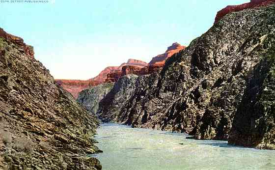
COLORADO RIVER AT THE MOUTH OF BOUCHER CREEK
The COLORADO RIVER, that looks like a silver thread from the rim of the Grand Canyon, is really one of the great waterways of this continent. This is one of the two principal Western tributaries and drains over 150,000 square miles of territory. It rises in Utah at the junction of the Grand and Green Rivers, and flows for hundreds of miles through canyon walls.
|
Special Thanks to the Grand Canyon National Park Museum Collection |
|
ADDITIONAL GRAND CANYON PENNY POSTCARD TRAIL VIEWS HERMIT TRAIL Trailhead to Dripping Springs Junction HERMIT TRAIL Santa Maria Springs, Cathedral Stairs and Hermit Camp HERMIT TRAIL Hermit
Creek and the Inner Gorge WEST RIM DRIVE Take the Hermit Rim Road and see Hermit's Rest |
|
|
This page hosted by ![]() Get your own Free Home Page
Get your own Free Home Page