Contents:

Introduction

Access

Description & Views

  Palo Alto Baylands North
 
  Ravenswood South

  Ravenswood North

  Ravenswood USFWS

Links


Bay Trail Links:

Bay Trail Home

Bay Trail Map: South Bay

Guided Photo Tours

   Palo Alto Baylands

   Dumbarton Bridge

   Menlo Park

   Don Edwards SFBNWR


Ravenswood


The Bay and shore near Cooley Landing, with the Dumbarton Bridge in the background

Introduction

During the Gold Rush era of the 1850's, banker Isaiah Woods and his business partners bought some land at the end of Bay Road and created the town of Ravenswood. It was named after Woods and the birds that nested there.  Woods hoped this area would become the last stop on the Trans-continental Railroad and would become the center of lumber and shipping. He built an expensive wharf that extended into deep water. It was the only port on the Bay between San Francisco and San Jose. However, because of a number of factors, the Port of Ravenswood failed, and the area became a ghost town. In 1868, successful gold miner and dairyman Lester Cooley bought the wharf and 400 acres of adjoining land. He restored the pier and used it for shipping grain and dairy products. It became known as Cooley Landing (also called Cooley's Landing). The area declined after Cooley's death. In the 1930's, Cooley Landing became the site of a county dump. From 1960's to the 1990's, it was the site of the Palo Alto Boat Works. After that, the 6.75 acres of Cooley Landing was sold to the Peninsula Open Space Trust, which has kept it as a nature conservation area. It is not open to the public yet, but hopefully will be in the future. It is in the heart of the Ravenswood area.

The Ravenswood area is between the Palo Alto Baylands and Menlo Park's Bayfront Park. The publicly-accessible portions consist of 3 sections divided by 2 Bay crossings: the Dumbarton Cutoff Railroad Bridge/Hetch Hetchy Pipeline and the Dumbarton Bridge. The Bay Trail runs through 2 of these sections and provides access to the third. The southern section adjoins the north part of the Palo Alto Baylands. The Bay Trail runs through the Palo Baylands and into the Ravenswood Open Space Preserve. It stops just south of the Dumbarton Cutoff Railroad Bridge. The smaller northern section is also part of Ravenswood Open Space Preserve. It runs along the Bay south of the Dumbarton Bridge and stops before the Hetch Hetchy Pipeline. North of the Dumbarton Bridge is the Ravenswood Trail, which is not part of the Bay Trail. It runs on levees around huge salt ponds southeast of Menlo Park's Bayfront Park.

Access Information

The Ravenswood Area is next to residential and industrial areas and major roads. The sections have many access points. The southern section is most easily accessible from the Palo Alto Baylands trails. The nearest public parking is at the Baylands Athletic Center at 1600 Geng Road. Geng Road is just off Embarcadero Road east of Hwy 101. The Bay Trail leads from the end of the athletic center, following San Francisquito Creek downstream to a bridge over the creek. On the other side of the bridge, it runs north next to a residential area in East Palo, from which there are several neighborhood accesses. The developed trail ends at Weeks Road. There is a narrow undeveloped trail along a fenceline leading to Bay Road. This 1100-foot section is slated to be developed into a multi-use trail in the future. Bay Road in East Palo Alto leads to the southern staging area and parking lot for Ravenswood Open Space Preserve. This is the Cooley Landing Site. The trail leads north along a marsh and stops just south of the Dumbarton Crossing railroad bridge.

To reach the next section requires going out on Bay Road to University Avenue to the paved bike path along Hwy 84. There are parking areas on the frontage road near the footing of the Dumbarton Bridge. Near the closed Dumbarton Pier entrance, there is an entrance to the trail along the Bay in the north part of Ravenswood Open Space Preserve. This is a dirt trail that turns into a very rough (currently) levee trail between the Bay and a salt pond. The trail peters out near the Hetch Hetchy Pipeline. This area was once the site of a shooting club and is being restored. Connecting the north and south parts of the preserve has been difficult because of the multiple agencies involved and issues of security, safety, and toxic contamination. Still, there are discussions going on that may connect them in the future.

North of the Dumbarton Bridge are huge salt ponds. They are part of the Don Edwards San Francisco Bay National Wildlife Refuge, run by the US Fish & Wildlife Service. The Ravenswood Trail runs on a levee around 2 of the salt ponds. This area is used for hunting and is closed to non-hunters during the winter hunting season. This trail is easily accessible from the frontage road on the north side of Hwy 84.  The frontage road runs under the Dumbarton Bridge, allowing access on both sides of the bridge. The Bay Trail from Menlo Park's Bayfront Park and the bike path across the Dumbarton Bridge provide easy access to these trails near the bridge.


Description and Views

The pictures below show views of the trail sections in the Ravenswood area. They are divided into these sections, from south to north:
Most of the pictures below were taken in May and July of 2007 and represent conditions at those times. A few were taken in July of 2008. Conditions and access rules are subject to change, especially as construction is being planned for these areas.


Palo Alto Baylands North


The best place to access the trail to Ravenswood is from the Baylands Athletic Center. There is a large parking lot at the center. The trail begins here and follows San Francisquito Creek. This tour begins here at the start of the trail. The mileage readings begin here, as measured by a GPS receiver. (GPS coordinates: N 37° 27.230 W 122° 07.273)


The trail from the athletic center follows San Francisquito Creek. The trail is paved. The Palo Alto Golf Course is to the right of the trail. The trail reaches a bridge over the creek at 0.52 miles. (GPS coordinates: N 37° 27.663 W 122° 07.411.) The bridge was completed in 1985 and is called the Friendship Bridge. It leads to Ravenswood and East Palo Alto. The bridge can also be reached by the Bay Trail coming from the mouth of San Francisquito Creek and past the end of the Palo Alto Airport.


This is a view from the center of the bridge, looking downstream towards the Bay. The Bay Trail runs on the levee to the right and passes the end of the Palo Alto Airport's runway. San Francisquito Creek is the boundary between Santa Clara and San Mateo Counties. This is not the original route of the creek. It was moved here in the 1920's.


On the west side of the creek, a sign shows that this area is part of the Baylands Nature Preserve. The city of Palo Alto purchased this 200-acre mashland in 1944, called the Faber-Laumeister Tracts, and still owns it, even though it is outside the Palo Alto city limits. It is also part of the Don Edwards San Francisco Bay National Wildlife Refuge, which is patrolled by the USFWS, who has law enforcement responsibility.


A gravel trail runs upstream along the west bank of the creek. It runs behind East Palo Alto residences. It approaches, but does not reach, East Bayshore Road. An entrance to the trail is at the end of O'Connor Street.


To the west of the trail is a fenced-off pond.


A little farther along the trail, this access trail entrance leads to Martin Luther King Park in East Palo Alto at the end of Daisy Lane. The park has baseball and soccer fields.


The trail is paved and ruler-straight, running next to a marsh on the right and open fields with power towers on the left. Behind them are residential neighborhoods in East Palo Alto.


The marsh is covered in cordgrass, with meandering sloughs running through it. Rancher Peter Faber once used this land for cattle grazing.  He sold it to Palo Alto in 1944, which considered using it for industrial development. Instead, in 1965, the city dedicated it as parkland. It was used for dumping bay mud dredged from nearby areas. In the 1970's, the area was opened to tidal flow and marshland vegetation was planted in it.


At 1.11 miles, near the end of Runnymede Street, a narrow, sometimes overgrown dirt trail runs east on a narrow levee between 2 marshes, and reaches the edge of the Bay. (GPS coordinates: N 37° 28.116 W 122° 07.594.) This is called the Faber-Laumeister Trail, which has the same name as the adjacent marsh. The main trail continues to the north.


After a short distance, the paved trail turns into a smooth gravel trail. The sign warns that the trail narrows ahead. It acknowledges that the trail ahead is an official trail, even though it doesn't look like one yet.


At 1.20 miles, near the end of Weeks Street, the trail turns into a rough, narrow, and somewhat overgrown path next to a fence. (GPS coordinates: N 37° 28.172 W 122° 07.631.) This 1100-foot long section is scheduled to be widened in the near future. It has already been partially widened. The unimproved section runs for 0.13 miles next to a fenced-in lot that is mostly empty. 


The trail becomes a wide, graded gravel trail behind the PG&E substation. After 0.2 miles on the gravel trail, 1.59 miles from the start, the trail reaches Bay Road and the entrance to the south part of the Ravenswood Open Space Preserve.


This is a view looking back at the newly-widened section of trail.

Ravenswood Open Space Preserve - South

The GPS coordinates for the entrance to the preserve on Bay Road are: N 37° 28.494 W 122° 07.578.


The sign near the preserve entrance shows this is a Mid-Peninsula Open Space Preserve. The access road and trail lead east.


At the end of the road and trail is a parking lot, with trail signs. There are no facilities here. The land beyond is Cooley Landing, which is currently not open to the public.


There is a handicapped-accessible bench for viewing the edge of the Bay at the mouth of a small slough. (See the picture at the top of the page.) The bench is at 1.76 miles. (GPS coordinates: N 37° 28.666 W 122° 07.444.)


Cooley Landing was once a wharf. For years, there was an old dredge there, behind a building that was once part of the Palo Alto Boat Works. The dredge was used to dredge the Bay sediments from the Palo Alto Yacht Harbor and other harbors to keep them clear for boats. The dredge was destroyed in a fire in April, 2008.


Heading back to the preserve entrance, a bridge leads over the slough to bike trails on the other side. The 1.3 miles of trails lead east to the Bay and north along the edge of a marsh. After the bridge, turn right and follow the channel to the Bay.


This trail branch leads to a viewing platform at the edge of the Bay at 2.07 miles. (GPS coordinates: N 37° 28.580 W 122° 07.479.) The trail dead ends here, so you need to backtrack back to the bridge.


The trail follows along the edge of a huge marsh to the right, next to a slough on the left side of the trail. Covering over 150 acres, the marsh was once a salt pond. It was opened to the Bay in 2000 and has been returning to a natural state. The trail parallels a chemical plant to the west. This was the Romic Environmental Technologies hazardous waste treatment plant. It was ordered to be shutdown in 2007.


The marsh is covered with pickleweed and traversed by small winding sloughs.


The trail passes by a large open field on the left, then turns to the right, heading east to the Bay.


Along the Way, the trail passes under powerlines. The catwalks to the power towers are closed to public access and are unsafe.


Just across a small marsh, the bed of the abandoned railroad line can be seen. This line once crossed the Bay at the Dumbarton Cutoff. Not visible on the other side of the tracks is the Hetch Hetchy Pipeline, which runs aboveground and goes underground near the big white building above. Just beyond that is the north section of the Ravenswood Open Space Preserve. The tracks and the pipeline have for years formed a barrier between the two parts of the preserve and a critical gap in the Bay Trail. Plans are being discussed to close this gap.


The trail parallels the train tracks, which run on an embankment above a marsh.


The trail approaches the pickleweed-covered shoreline at the edge of the Bay. The Hetch Hetchy Pipeline extends out into the Bay on piers. The small building at the end of the pier is where the pipeline resurfaces after traveling under the Bay from Fremont. The remains of the Ravenswood Cutoff train tracks lead to a rotating span, which has been welded open to allow boats to pass through. This was the first train bridge across the Bay and operated from 1910 to 1982. After it was closed, vandals burned the wooden western section of the bridge. SamTrans owns the western portion of the rail line. The train line may be revived in the future by the Dumbarton Rail Corridor Project, which proposes a 21-mile rail connection between Union City and Redwood City.


Above are the burned remnants of the train trestle pilings. Beyond is the Hetch Hetchy Pipeline. On the other side of the pipeline is the trail on the north side of the Ravenswood Open Space Preserve (see below). This shows how close the trail sections are.


The trail turns right and heads south to a viewing platform, a twin of the one near Cooley Landing.


At 3.43 miles, the trail ends at this viewing platform, with views of the Bay, the restored marsh, airplanes taking off from the Palo Alto Airport, and Cooley Landing. (GPS coordinates: N 37° 29.085 W 122° 07.469.)

Until the connection is made across the train tracks and pipeline, the only way to reach the northern part of the preserve is to backtrack along the trail to Bay Road. Take Bay Road to University Avenue. Turn right and follow it to the trail along Hwy 84. This is not a particularly attractive or safe route, so it may be better to drive it.  However, in the future, this will be the heart of the Ravenswood Business District, which will have residential, retail, commercial, and industrial developments.


Ravenswood Open Space Preserve - North


The paved Bay Trail parallels eastbound Hwy 84 on the way to the Dumbarton Bridge. Along the way is a rest area with interpretive signs. A frontage road leads off Hwy 84 near here and leads to parking areas by the base of the bridge.


To the south of the Dumbarton Bridge is the entrance to the north part of Ravenswood Open Space Preserve. A trail runs for about half a mile from here.


The trail runs along the edge of the Bay, with views of the Dumbarton Bridge and the now-closed Ravenswood Fishing Pier. The pier was once part of the old Dumbarton Bridge, which was closed and turned into fishing piers on both ends. Note that the Ravenswood pier is closed to the public indefinitely, but the Dumbarton Pier on the Fremont side is open for fishing.


The trail runs along the edge of a large salt pond, designated SF2. There are pipes and pumps in the pond. The Cargill Trans-Bay Pipeline ends here, bringing salt brine from the opposite side of the Bay.  Plans are being made to restore this salt pond to a more natural state, as part of the South Bay Salt Pond Restoration Project. This area is likely to look dramatically different in the future.


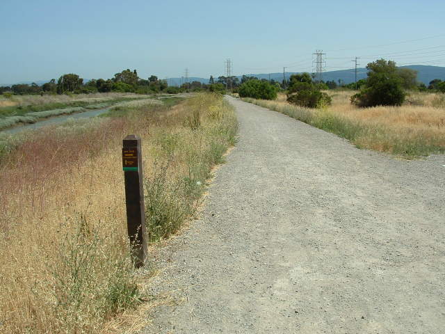
The trail starts as a rough gravel trail and turns into an even rougher dirt trail along a levee. Plans call for improving the trail with a decomposed granite surface and adding two viewing platforms.


The trail surface is dried bay mud. It can be impassable in wet weather and very bumpy in dry weather.


Depending on the season, the salt pond may be covered in dry salt. The highly saline water may be red due to salt-loving bacteria. The pond was drained to facilitate cleanup activities. Parts of the pond bottom had lead contamination from hunting. In the future, the pond will be open to tidal flow from the Bay. Small islands will be created in the middle of the pond to  provide nesting sites for birds.


The trail gets rougher and more difficult to walk on as it approaches the Hetch Hetchy Pipeline ahead. The  trail has not been surfaced (as of 2007) and is only smooth where trail users have passed over it. The preserve ends around here, but there are no signs or fences indicating the boundary.


The trail becomes barely discernible along the levee, which turns to follow the salt pond. There is a large, flat open area ahead, but this is the site of a former skeet shooting range, which is full of toxic lead shot. Cleanup efforts need to be completed before this area is opened to the public. The 
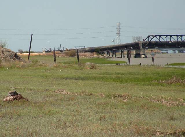
Hetch Hetchy Pipeline goes underground near the white building above.


The Hetch Hetchy Aqueduct pipeline crosses over land, running above the marsh on wooden supports, then goes over the Bay on a long pier. After traveling aboveground for some distance above the wetlands, it goes underground (see above). The pipeline carries water from Hetch Hetchy Reservoir in Yosemite and takes it to water users in San Francisco and the Peninsula, with a total length of 167 miles. The pipeline is owned by the City of San Francisco, so this is a little strip of San Francisco.

At this time, there is no way to go farther south on the trail. Backtrack along the trail to the entrance by the Dumbarton Bridge. Take the road under the bridge to reach the north side.


Ravenswood Trail, USFWS


At the north side of the Dumbarton Bridge, is a viewing area with interpretive signs.


The 3.2-mile Ravenswood Trail is on USFWS land north of Hwy 84. It has one entrance on the east, near the Dumbarton Bridge and one farther west. This is the east entrance, just off the frontage road. It is a public trail, but it is not part of the Bay Trail. However, during hunting season, from late October to late January, it is open only to licensed hunters. The trail runs around the perimeter of 2 salt pond, designated R1 and R2.


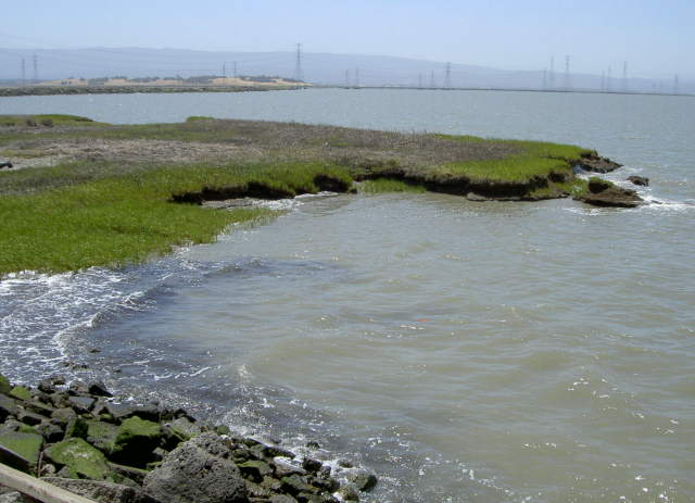
To the right of the trail is a large tidal marsh.


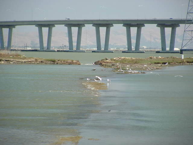
The breach in the outer levee allows the Bay water to flow into the pond, which is teeming with birds.


The trail passes by the end of the tidal pond and reaches the edge of the Bay.


The trail runs on a wide, flat salt pond levee, with the salt pond on one side, the Bay on the other. The Bay shoreline is lined with pickleweed in this section.


As the trail follows the edge of the salt pond, the northernmost point is called Ravenswood Point. The trail turns west.


 As it turns to the west, the shoreline is covered by riprap to protect it from erosion due to waves on the Bay.


On the salt pond side, depending on the season, are huge expanses of dried salt and wide brine channels running through them.


There are small pickleweed-covered points on the shore.


There are tiny sandy beaches on the shore.


The trail turns to the south and away from the Bay. There is a small sandy cove here. The hills of Menlo Park's Bayfront Park can be seen in the background.


Ravenswood Slough winds along the west side of the trail.


Finally the trail ends at a gate off the frontage road along Hwy 84. From here, you can go southwest to the Bay Trail, which leads to Menlo Park's Bayfront Park, or back northeast along the frontage road to the Dumbarton Bridge. See the Bay Trail Links above for descriptions and access to nearby areas.


Links


Developed: 7/27/2008 by Ronald Horii
Information and opinions expressed here are the responsibility of the author.