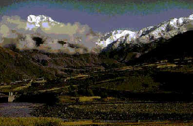
Photo of a section of the
Hindu Kush Range in the north of Afghanistan.
With this
page, we hope to provide a continuously updated collection of
images tracking all significant climatic changes in the Hindu
Kush Region. The images posted on this site are
collected by our Groundstation Crew from the NOAA 14
satellite. Our group will endeavor to edit the expansive
images and provide a closer and more detailed look at the Hindu Kush mountains in the north of Pakistan.

-
On
this topographical map, the Hindu Kush is the entire
region found to the left of the blue line and circled by
the red line.
-
The Hindu Kush is
a major mountain
system in central Asia.
It extends generally in a southwesterly direction
from the plateau region of the Pamirs on the borders of
Afghanistan to North-West Frontier Province, Pakistan; and
Tajikistan. The system lies largely in northeastern
Afghanistan.
-
In
the first section west of the Pamirs, the Hindu Kush
extends southward. In this section the system has a
plateau like summit, dotted with small glacial lakes. The
system then turns to the southwest and gains in elevation,
and the plateau summit breaks into peaks, the highest of
which is Tirich Mìr, in Pakistan. Many other peaks in
this section rise more than 6096 m, and the system is
broken by such passes as the Baroghil, the Dorah, and the
Khavak. The Hindu Kush is also the source of many rivers;
the most notable are the Amu Darya River on the northern
slopes and the Helmand, Kabul, and Konar Rivers and
several tributaries of the Indus River on the southern
slopes.
(map and information culled from the International
Center for Integrated Mountain Development)

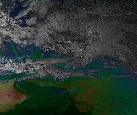
October
15, 1999
This picture, taken in
mid-October of this year, shows the Hindu Kush Mountains in
the upper left corner. There is little sign of snow and no storms are billowing
over the range either, as they are over
the north western part of India, caught in the lower right
part of the image.
November
12, 1999
This picture, taken in almost a
month after the first, shows the Hindu Kush Range in the
center of the image. As one can see, the area is
obscured by clouds, but dotted peaks of white can be spotted
amidst the gray, showing the growing of snow on the
mountains.

November
14, 1999
In this image, we see the Hindu
Kush Range in the top left corner. Clouds coming in from
the west partially cover the range, but as it is some snow can
be seen on the mountains.

November
15, 1999
This picture boasts almost no
cloud cover, and in the top left corner we can see huge
amounts of white covering the northern-most part of the range.

December
15, 1999
This picture shows the Hindu
Kush region in the top right hand corner. Snow can be
seen covering the gray peaks visible there.
Though these
five pictures are all we have for the moment, we are going to
be continually adding and improving upon this page.
Beginning in January, we will work to post at least one
picture of the Hindu Kush Mountains a week. By doing
this over the course of a few months, we will be able to study
weather patterns and truly track climate changes in the mountain area.
At our
school's past archive of pictures, one can find a set
of three satellite images
of the
Hindu Kush which serve to illuminate the definitive seasonal
change which occurs there during Spring, Summer, and Winter.
page
created by the
sciencedopes

|