

FISH
HOEK / VISHOEK
Province: Cape (now Western Cape)
Division: Cape
Magisterial district: Simon’s Town
Incorporated: into South Peninsula (1995)
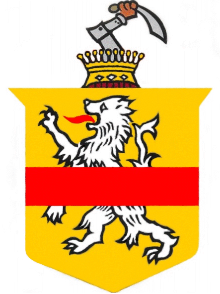
The arms may be blazoned:
Arms: Or, a lion rampant argent, langued gules, overall a fess gules.
Crest: Issuant from an earl’s coronet, a dexter arm vambraced, the hand proper, holding a scimitar proper, hilted or.
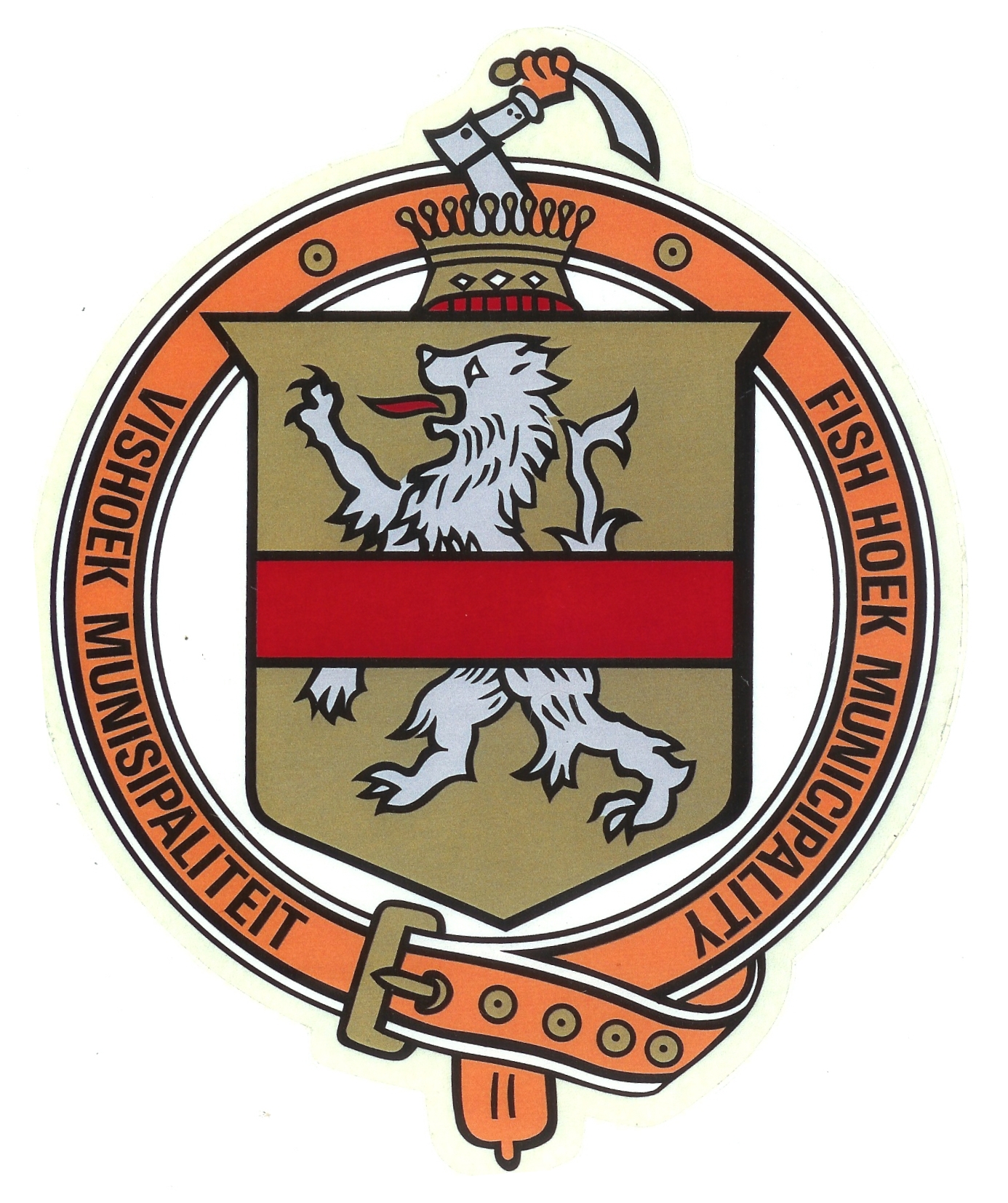
The arms as borne by the town would not have received any acknowledgement from the State Herald, since they are a breach of the colour rule: the lion is silver on a gold field.
The shield is taken from the Bruins family, to which the land on which the town was eventually laid out was granted by Lord Charles Somerset, and the crest from the De Villiers family which later owned the land.
According to Rietstap’s Armorial Génèral, there is a Bruins family in East Flanders (Oost Vlaanderen) which bears arms or, a lion rampant sable, overall a fess gules. The colour of the lion was clearly changed so as not to infringe on that family’s rights, but the choice of argent (silver or white) was a poor one.

The arms of De Villiers as reflected in the books by Cor Pama show a crest of the same design, except that the hand is in a greave (metal glove), and the sword is all silver or steel, not gold.[1]
The coronet seems to be an embellishment by the town council. Aside from the fact that it is irregular (a helmet should have been used instead), it is not in the standard shape, and the extensions of the rim are shown as bearing gold balls, whereas traditionally these were pearls (five of them) and in the coronets actually worn by British earls at coronations, the pearls are substituted by silver balls, and are separated by strawberry leaves in gold. The illustration shows 11 gold balls and no leaves.
The arms were agreed on by the newly formed town council in 1941. Letterheads were printed and ties made for male employees, as well as scarves for female employees, all bearing the shield of arms.
It was proposed to obtain a grant from the College of Arms in London. However, in view of the colouring, the heralds wanted nothing to do with the arms in these colours. In view of the expenditure already laid out in establishing these arms, it was decided to ignore the College, and to continue using the arms. They remained in use until the municipality’s incorporation into South Peninsula.
The image is taken from a decal which was affixed to the doors of municipal vehicles.
The town also had a flag, a vertical tricolour in yellow, black and yellow, with the arms placed on the black stripe, the lion facing the hoist on both sides.
About the town:
Fish Hoek lies 31 km south of Cape Town and is nestled in Fish Hoek Bay, an inlet in False Bay on the east side of the Cape Peninsula. The town has now spread roughly halfway to the Atlantic shore at Long Beach, although there is a wetland and a large dunefield preventing further expansion in that direction.
The town is renowned for its bathing beach. The mean summer temperature of the water is 20°C.
Fish Hoek lies at an interruption in the Peninsula mountain chain, being built on dunes between the Kalk Bay mountains (highest peak 516 m) to the north and, on the southern side, a mountain ridge named separately as Else Peak (302 m, south-east of the town) and the Brakkloofrant (305 m, south-west), although they form a single rock wall running north-west to south-east.
Also on the northern side is the peak Skildersgat (172 m), where the skull of the famous Fish Hoek Man was discovered by Victor Peers and his son Bertie in a cave, now called Peers Cave, during excavations in the years 1927 to ’29. The skull is that of a human being who lived about 10 000 years ago.
Between Skildersgat and the Kalk Bay mountains runs the Silvermine River, which has its mouth on the northern side of Fish Hoek Bay. The river takes its name from a salted excavation about halfway up the course of the river where a claim was made in 1687, when Simon van der Stel was Commander at the Cape, that silver had been discovered. Despite extensive further excavations, no payable silver was ever found.
The Silvermine River, at its mouth, marked the northern boundary of the Fish Hoek municipality. On the left (north) bank lies Clovelly, a small residential area belonging to Cape Town, nestled on the slopes of Trappieskop (240 m), the southernmost peak of the Kalk Bay mountains. A single row of houses perches above Main Road and the railway line, while several more are to be found inland. Upriver from this area is the Clovelly Golf Club.
The name Vishoek is first encountered in 1725, although this name was also at that time applied to Gordon’s Bay, on the north-eastern corner of False Bay.
In 1818 Governor Lord Charles Somerset granted 2 761 acres (1 117 ha) of land in this vicinity to Andries Bruins. Among the title stipulations was a requirement that no public wine-house should be kept, and that the right of fishing should be free.
Bruins’s home, later known as the De Villiers homestead, appears to have been the first house built in Fish Hoek. The site was later occupied by the Homestead Hotel.
In 1901 Jacob de Villiers bought the land, at which time an additional servitude was imposed, that non-white people should not own land, reside or trade there.
The Standard Encyclopædia of Southern Africa (published in the 1970s) states that these three conditions are still in force, despite attempts to have them lifted. Until the 1980s the only places where liquor could be served were the sports clubs, but the restriction on liquor was eventually lifted. The racial restriction fell away when group areas were abolished.
The railway line to Wynberg (one of the first built in the Cape Colony) was extended as far as Kalk Bay (roughly 2 km north-east of the De Villiers homestead) in 1883. In 1889 construction began on the further extension of the line to Simon’s Town. One of the greatest engineering problems was the crossing of the sandy estuary of the Else River, at what is now Glencairn. The line reached Simon’s Town (or rather, a point about a kilometre north of the town) on 1 December 1890.
The single-track line was later doubled as far as Fish Hoek, but the line to Simon’s Town remains a single track to this day.
The railway line, as it runs from Muizenberg to Simon’s Town, follows the route of Main Road. This was the wagon road which linked Simon’s Town to Cape Town from the early days. In the 1970s the Cape Divisional Council built a new road over the mountains, starting at Steenberg (behind Muizenberg) and following the Silvermine River down to the rear of Skildersgatkop. Under the mistaken belief that there had once been a wagon road over the mountains, and that this alleged road had been superseded by Main Road, the council named this new road the Ou Kaapse Weg (Old Cape Road). This travesty continues.
In 1919 De Villiers’s heirs subdivided the farm Vischhoek and a village was laid out. In 1921 a local board of three members was set up, and in 1927 this was expanded to a village management board of six members.
The municipality of Fish Hoek was proclaimed in October 1940 and the first council elected early in 1941.
The population in 1960 was 5 213 white people, 194 Coloured and 198 black people (“Bantu”). These last two figures are surprising in view of the restrictions on the residence of brown and black people.
The town was absorbed into the South Peninsula Municipality (a subdivision of Greater Cape Town) at the time of the local elections of 1995. It is now part of the Cape Town Unicity.