Hurricane
Hugo - September 22, 1989.
WINDS:
140-mph.
PRESSURE:
27.58 inches (934 mb).
STORM - SURGE: 16 - 20-feet above mean tide.

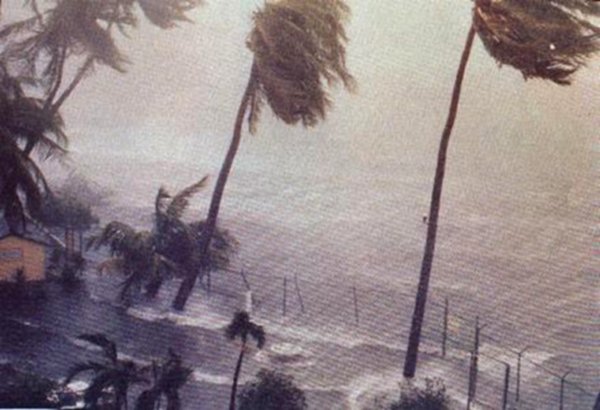
Resort
hotels in Puerto Rico are battered as Hurricane Hugo sweeps across the island
in September 1989. (Photo PRUS - 1990).
Hurricane
Hugo is the most intense tropical cyclone to strike the United States Atlantic
coast north of Florida on record.
Along the United States east coast (north of Florida) - no tropical cyclone
has ever recorded a lower pressure, stronger winds, or a higher tidal surge
than Hurricane Hugo in 1989. The only hurricane that approaches Hugo's stature
in the 20th century along the North or South Carolina coast is Hurricane Hazel
of 1954.
For
twelve-days in September 1989, Hurricane Hugo captured the attention of millions
of people across the Caribbean and the eastern United States. Hugo traveled
more than a thousand miles with great intensity. On
September 22, five-days after Hugo had left Guadeloupe and Montserrat in shambles,
the cyclone was 1,500 miles away - battering the U.S. mainland in South Carolina
with 140-mph winds. In terms of size, intensity, duration, and destruction
- Hurricane Hugo is one of the greatest storms to ever affect the Caribbean
and the U.S. mainland.
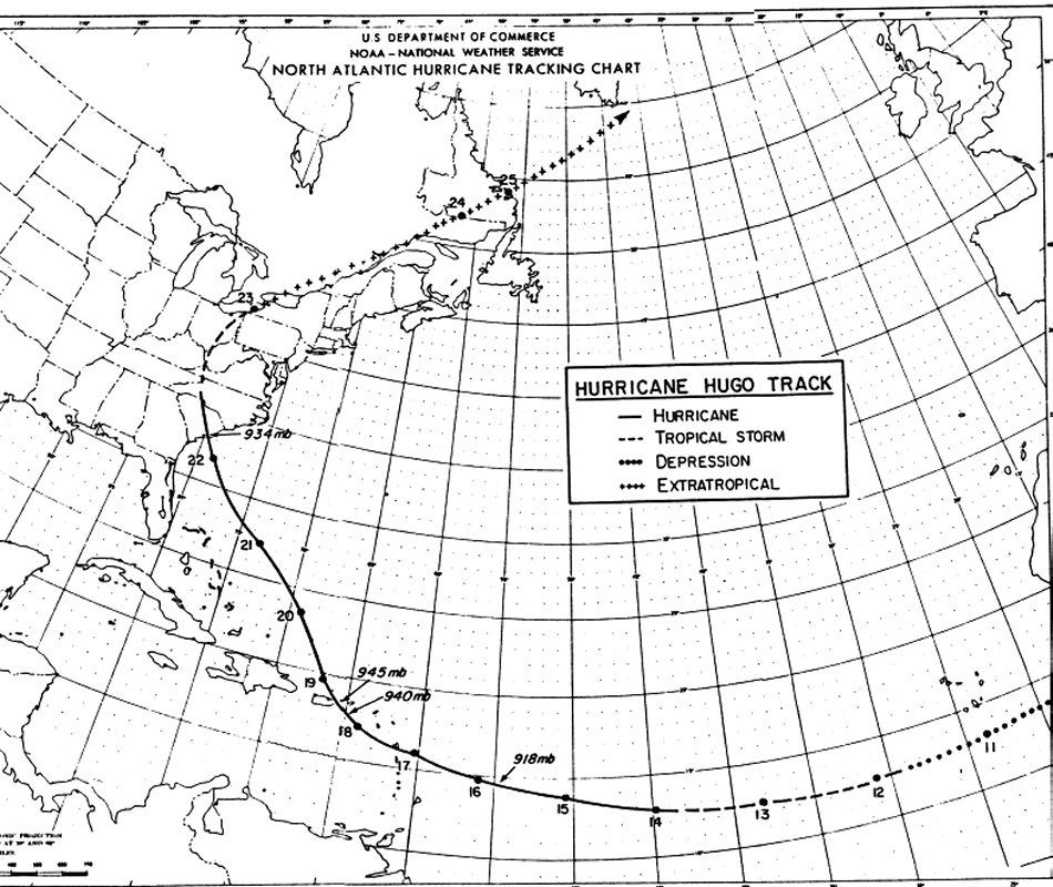
Hurricane
Hugo's 3,000 mile track from Africa to the United States.
(Chart
courtesy of National Hurricane Center -1990).
Hugo
was a classic Cape-Verde tropical cyclone that formed from an area of disturbed
weather that emerged off the coast of Africa. On September 10, a depression
had formed about 300 miles southwest of the Cape Verde Islands. The westward
moving depression reached tropical storm strength late on September 12th.
Based on satellite estimates, Hugo became a minimal hurricane late on September
13th. By September 14th, the intensifying cyclone was estimated to have winds
in the 110 - 115 mph range. However, Hugo was still almost 1,000 miles away
from any land area.
NOAA
reconnaissance aircraft reached Hugo late on September 15th, in what turned
out to be a historic and dangerous mission. The reconnaissance flight penetrated
the eye of Hugo expecting to find winds in the 100-mph range - instead,
the crew and aircraft of this mission were nearly lost. Satellite estimates
had greatly underestimated the hurricane's strength. In a dangerous low altitude
penetration into the eyewall, the crew of this flight recorded sustained winds
of 190-mph, and a barometric pressure of 27.10 in. (918 mb). Based on aircraft
data, Hugo was estimated to have 160-mph sustained surface winds (category
five hurricane). The NOAA aircraft was battered and damaged in the extreme
weather conditions. The pilots of the NOAA mission were forced to dump 50,000
pounds of fuel to escape from inside the intense eye of the hurricane.

LEFT:
The eye of Hurricane Hugo
just to the southeast of St. Croix on September 17, 1989 .
RIGHT:
Severe weather conditions on Montserrat Island as Hurricane Hugo approaches
(NOAA Photo Library).
On
September 17th, Hugo slammed into the islands of Guadeloupe and Montserrat
near midnight with sustained winds of 140- mph winds (gusts 170-mph). Damage
was extreme throughout Montserrat and in several parts of Guadeloupe Island.
Twenty-one people were reported killed, while 12,000 people (nearly the
entire population of Montserrat) were left homeless. After passing over
Montserrat, Hugo then struck the U.S. Virgin Islands. On St. Croix, the devastation
was tremendous - hundreds of roofs were ripped off homes, and many of the
islands hotels and resorts were destroyed. Hugo was the worst hurricane in
the history of St. Croix ($1 billion in damages in St. Croix alone). Thousands
of people were left homeless, and widespread looting on the island forced
President Bush to dispatch military police to restore order.
Hugo then turned more northward and struck the far eastern tip of Puerto Rico
at 12:00 AM on September 19th. Northeastern Puerto Rico was struck with high
seas and sustained winds of 125 mph - suffering heavy damage. On the Island
of Culebra, just north of Vieques, the ship Night Cap, recorded a gust
of 170-mph while riding out the storm in the harbor. Twelve people were reported
to have been killed in the storm, while over 30,000 are left homeless across
Puerto Rico. Crossing the mountainous terrain of Puerto Rico, Hugo weakened
as it emerged into the Atlantic Ocean late on September 19th.

The remains of hundreds of buildings
scattered across Vieques, Puerto Rico after the passage of Hurricane Hugo
in September 1989 (Photo NOAA Photo Library).
On
September 20th Hurricane Hugo continued moving northwest just to the east
of the Bahamas in the direction of the U.S. mainland. The National Hurricane
Center estimated Hugo would strike the United States in South Carolina and
hurricane warnings were issued. An estimated 250,000 persons fled the low
lying areas of Georgia, South Carolina, and southern North Carolina in advance
of Hugo. As
Hugo continued moving northwesterly, the storm begin to grow in size and intensity
over the warm waters of the Gulf Stream. Incredibly - in the final ten hours
before landfall, Hugo rapidly strengthened to a category four hurricane with
sustained winds of 140- mph. The eye of Hugo passed over Sullivan's Island,
South Carolina near midnight on September 21st. Hugo was the first major
hurricane to cross the South Carolina coast since Gracie in 1959.
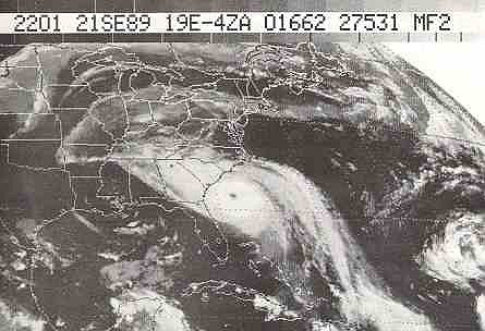
Hurricane
Hugo closes in on South Carolina with 140-mph winds late on September 22,
1989. Hugo was twice the size of Hurricane Andrew (1992) but less intense.
Hugo is the most intense hurricane to ever strike the United States Atlantic
coast north of Florida (Photo NOAA).
METEOROLOGICAL
CONDITIONS IN THE UNITED STATES
Based
on reconnaissance aircraft reports, Hurricane Hugo had sustained winds of
around 140-mph when the eye crossed the South Carolina coast.
As with most severe landfalling hurricanes, few wind reporting stations were
near the area of strongest winds, or survived to record them. The ship "Snow
Goose" anchored in the Sampit River, recorded sustained winds of
121-mph. The very strongest winds of the hurricane passed over the unpopulated
Francis Marion National Forest. It has been estimated that in this area, from
around Bulls Bay to the Santee River, peak wind gusts were likely in
the 160 -165 mph range. The National Weather Service Office (NWS) in
Downtown Charleston recorded gusts to 108 mph.
Reconnaissance
aircraft also reported a barometric pressure of 27.58 (934 mb) just before
the eye crossed the coast. A pressure of 27.66 in (936.5 mb) was recorded
by storm chaser Jim Leonard on the Savannah Highway near Charleston. This
is the lowest known land- based barometric pressure ever measured in Georgia
or the Carolinas. There were several reports of pressure in the 936 -
938 mb range near the landfall area around Charleston. The National Weather
Service in Charleston recorded a pressure of 27.87 in (943 mb).
Hurricane
Hugo produced the highest tidal surge ever recorded along the United States
Atlantic coast. According
to the U.S. Army Corps of Engineers (Charleston District), tides reached 19.8-feet
above mean sea level at the Romain Refuge Housing Development. The U.S.
Fish and Wildlife building at Moores Landing, had a 19.3 foot water mark.
Tides 13 - 16 feet above msl were noted near the McClellanville docks. Charleston
recorded tides 8 feet above msl near the Custom House.

Building on Sullivan's Island, South
Carolina carried inland during Hurricane Hugo's storm surge (Photo WSED-1990).
THE
IMPACT
The
bulk of Hugo's fury was unleashed over the rural area north of Charleston,
and over the Frances Marion National Forest. This was the area that was located
in the eastern eye of Hugo. Fortunately, this area was very sparsely populated.
The National Forest of loblolly pines was decimated by the intense winds.
The forest looked quite strange after the storm - tens of thousands of trees
were sheared off at a height of 15 or 20-feet above the ground. The USDA Forest
Service reported Hugo destroyed $100 million worth of timber alone.
Hurricane
Hugo ran over the barrier island communities of South Carolina like a freight
train. After Hugo had passed, damage reports slowly came in. From the air
- news helicopters showed whole swaths of buildings roofless and gutted. Several
buildings had been swept right off their foundations - as if hit by a tidal
wave. As local and national media coverage of the destruction increased, residents
soon realized the enormity of what had occurred out on the islands: the combination
of tides 20-feet above normal and winds gusts in excess of 160-mph caused
some of the worst cyclone damage along the U.S. east coast ever experienced.
Folly
Beach suffered some of the worst destruction wrought by Hugo. About 80% of
the homes on the island were destroyed. The main scenic road that runs along
ocean (Arctic Avenue) was stripped bare of its pavement - a mass of house
wreckage strewn across it. Hundreds of beachfront homes were gutted or flattened.
In a pure demonstration of power - The Atlantic House, an over the water restaurant,
was completely swept away, only the pilings of the 13,000 square foot restaurant
were found the morning after the storm.


The Atlantic House Restaurant
and beach - before and after Hurricane Hugo (Photo NOAA).
Sullivan's
Island and the Isle of Palms were also battered by Hugo. Homes were knocked
off their foundations, streets were covered with furniture, roofing material,
boats, and dead animals. Poisonous snakes that had been driven out of the
marsh curled around mangled debris. At the Dunes marina, at least 100 boats
were stacked in a 50-foot high pile. The 40-ton swing span section of the
Ben Sawer Bridge, was ripped lose from its steel lock pivots, and crashed
into the waters of the Atlantic Intercoastal waterway.
Although
the severest conditions in Hugo were experienced just to the northeast of
Charleston - the city was battered. Charleston City Hall and the fire station
lost their roofs during the hurricane, while a dozen or more historic churches,
and the City Market had severe roofing damage. More than half the cities 4,000
historic structures suffered some type of damage. Tidal flooding along the
Battery was severe, with many historic structures receiving flood damage.
In was estimated that more than 80% of the historic buildings in Charleston
were damaged to some extent. The beautiful moss-draped live oaks of Hampton
Park and White Point Gardens were knocked down, as was many of the cities
palmetto palms.

Ben
Sawyer Bridge lies partially submerged in the Atlantic Intracoastal Waterway
following Hurricane Hugo in September 1989 (Photo courtesy UACE Charleston
District - 1990).
Although
the barrier islands had been mostly evacuated - nothing could prepare residents
of the South Carolina coastal plain for the fury of the storm surge that rushed
across the marshes. Two small fishing communities about three miles from the
coast, Awendaw and McClellanville, were submerged by tides 20 feet above normal.
The tidal wave-like surge produced terrifying ordeals in many low lying communities:
|
In McClellanville, more than three miles from
the ocean, most of the towns 600 residents took shelter in the Lincoln
High School. The building had been selected as a shelter because it
was sturdy and 16 feet above sea level: It would offer shelter for people
from low lying areas.
During the storm, water first rose around
the school and the parking areas, then broke through the doors of the
building. Evacuees stood on tables and chairs in an attempt to stay
above the rising surge. Water continued to swiftly flood the school.
Around 1:00 am water was still rising quickly as the power went out.
Many terrified evacuees swim out windows, convinced the school building
would be totally submerged. Struggling in darkness, parents lifted screaming
children into the roof rafters in neck deep water, as the storm surge
rose to to within a few feet of the ceiling. Fortunately, everyone at
the Lincoln school survived, however, residents and county officials
were shaken to the core.
|
Due
to the extreme intensity of Hugo when it crossed the South Carolina coast
- the storm roared through inland communities with unimaginable fury. Many
residents of inland areas had not fled mobile and manufactured homes for more
substantial shelter, expected only dangerous conditions near the coast. Hugo
marched thorough the South Carolina killing scores of people, destroying property,
and leaving untold sorrow. Many who had fled the coast found themselves in
frighting weather conditins while they waited in motels, shelters, and schools.
In
Berkeley county (80 miles inland) wind gusts up to 120-mph, destroyed twelve
hundred mobile homes - killing eight residents. In Dorchester county, mobile
homes, five apartment buildings, and the Galleria Shopping Center were leveled.
In Clarendon county, Clarendon Memorial Hospital suffered extensive damage,
and the roof of the new county courthouse was ripped off. In Florence, the
Travelers Inn along I-95 lost its roof at the height of the storm, sending
two-hundred terrified evacuees running through the darkened buildings trying
to find shelter.
Almost
two-hundred miles inland Hugo still had 100-mph wind gusts. The major metropolitan
area of Charlotte, North Carolina suffered extensive damage. Thousands of
large trees fell into homes and business around Charlotte, and glass was shattered
in downtown skyscrapers. Torrential rains in Virginia flooded roads and cut
power to 2 million people. By late on September 22nd, Hugo finally died over
the cool forests of southern Canada.
Unfortunately, despite all media coverage and advanced warnings Hurricane
Hugo's human toll was high. Hugo claimed twenty lives in South Carolina.
Several of the fatalities occurred in the mobile home communities northwest
of Charleston. Other fatalities occurred in North Carolina (seven),Virginia
(six), and upstate New York (one), bring the U.S. death toll to Thirty
five. In the Caribbean, twelve were killed in Puerto Rico, six in the
Virgin Islands, ten in Montserrat, one in Nevis and Atigua, and eleven in
Guadeloupe. The total death toll from Hugo was seventy-six.
Hurricane
Hugo was the most expensive tropical cyclone to ever strike America up to
that time (1989). Hugo was one of the greatest natural disasters in U.S. history.
Damages were estimated at $10 billion - with $7 billion in the United States
and $3 billion in the Caribbean. Insured losses stand at $4.2 billion.
A week after the storm, 56,000 people were homeless in the Carolina's (FEMA
- 1991). Twenty-four South Carolina counties were declared Federal Disaster
Areas. As late as 2000, many residents were still rebuilding from one of the
worst tropical cyclones to ever strike America.
BACK
©
Michael A.Grammatico 4/06