
Hurricane Bob approaching the Rhode Island coastline in August 1991 (Photo courtesy NOAA).
Hurricane Bob hit Rhode Island and southeastern Massachusetts as a moderate hurricane in 199. Bob was small in size - but concentrated great power in isolated areas. Fortunately, a northeasterly track kept most of Long Island, Connecticut, and western Rhode Island on the weaker side of the hurricane. This was fortunate, since Bob was stronger than Gloria in 1985. Unlike Gloria, which arrived at low tide - Bob's storm surge was significant, and several areas in Rhode Island and southeastern Massachuttess reported extensive wind and storm-surge damage. Damage in several areas was at levels not seen since Hurricane Carol in 1954.
Hurricane Bob developed from a persistent area of clouds just to the east of the Bahamas. By August 17th, Bob was located about 200-miles east of the central Florida coast, with winds of 75-mph. By the 18th, Bob begin turning in a more northerly direction, continuing to intensify. As the storm swept past the North Carolina Outer Banks - the Diamond Shoals Light buoy recorded sustained winds of 99-mph and a peak gust of 123-mph. Bob continued to intensify early on August 19th - reaching major hurricane strength about 80-miles east of Virginia Beach,with sustained winds of 115-mph and a barometric pressure measured at 28.05 inches (950 mb).
Six hours later (1:30 p.m.) the eye of Hurricane Bob passed just to east of Montauk Point, New York, then passed right over Block Island, Rhode Island. After passing over Block Island - the eye of Bob become disorganized and begin to fill with clouds. Bob crossed the coast of the United States mainland near Newport, Rhode Island about 45-minutes after striking Block Island. Bob moved through eastern Rhode Island and southeastern Massachusetts, the center passing over Fall River and Plymouth, and then passing just off the tip of Cape Cod near Provincetown. As Bob passed the over Provincetown and moved over the cooler waters off New England, the storm quickly weaken to tropical storm strength before crossing the coast of Maine. Although Bob's track spared most of the region, coastal Rhode Island, Buzzards Bay, and the lower Cape took the brunt of the storm.

Storm-surge damage on Buzzards Bay in Wareham, Massachusetts from Hurricane Bob in 1991 (Photo Courtesy of Cape Cod Times-Photographer Steve Heaslip.)
METEOROLOGICAL CONDITIONS IN THE UNITED STATES
As the western tip of Bob's eye passed over Montauk Point and over Block Island, Air Force Hurricane Hunters reported a central pressure of 28.40 inches (962 mb) and sustained winds of 105-mph. Bob was weakening swiftly, and hurricane hunters reported the eye falling apart after passing over Block Island. Bob then crossed the coast near Newport, Rhode Island with a central pressure of 28.47 inches and sustained winds of 95 -100-mph. The Navy ship USS VALDEZ, anchored in Narragansett Bay, reported a pressure of 28.47 inches (964 mb). Many locations near the center of Bob in southern Rhode Island, reported minimum pressures between 964 - 966 mb. These readings were the lowest in the area since Hurricane Donna in 1960. In Massachusetts, the South Weymouth Naval Air Station reported a barometric pressure of 28.67 inches (971 mb). The lowest reported pressure along the far eastern Connecticut coast was 28.85 inches (977 mb) in Stonington.
As Hurricane Bob swept over Montauk Point and Block Island there were several official reports of winds over 100-mph. Montauk Lighthouse at the very tip of eastern Long Island, recorded a gust of 101-mph. In Rhode Island, Block Island reported gusts to 105-mph (instrument limit ), while winds of 89-mph with gusts to 100-mph were recorded in Narragansett. The NOAA Ship OREGON II, recorded sustained winds of 97-mph with gusts to 109-mph in Provincetown, while wind gusts hit 110-mph on the New Bedford Hurricane Barrier. In far eastern Connecticut, a U.S. Coast Guard Cutter off Gtoton, recorded sustained winds of 86-mph with a peak gust of 100-mph. There were also several dozen unofficial wind measurements of gusts between 100 and 120-mph across many sections of southeastern Massachusetts and east coastal Rhode Island - including a gust of 125-mph at Block Island Airport.
Hurricane Bob produced a storm-surge of 6 to 10-feet across the landfall area. Bob caused the worst storm surge flooding since Hurricane Donna in Rhode Island and Massachusetts. As expected, the highest surges associated with the storm occurred just to the east of the track. The U.S. Coast Guard Station at Montauk, estimated Bob had a storm-surge of 10-feet above normal at the very tip of eastern Long Island. Along the Rhode Island coast near the Newport, Bob's storm surge was estimated at 6 to 8-feet above mean tide. The highest surges were in Buzzards Bay. The track of the storm drove water up this narrow estuary where it reached an estimated 9-feet above mean tide. In Providence, the feared repeat of catastrophic flooding in Narragansett Bay was avoided by the storm's track, and at least partly, due to the Providence Hurricane Barrier. The tide against the barrier reached 6.6- feet above mean tide.
THE IMPACT
The northeast track of Hurricane Bob reduced wind and storm-surge damage across the region. However, Bob produced significant damage in many areas from Newport, Rhode Island eastward to the Cape and Islands. Had a larger part of the eastern side of the storm crossed over land - structural damage would have been extensive.
In Rhode Island there was heavy damage in Newport along both Bailey's and Easton's beaches - with heavy damage to more than 200 bath houses and cabanas. In both Bristol and Barrington, the roof of several fire stations were ripped off at the height of the storm. As the dangerous eastern semicircle of the cyclone passed over Little Compton - the winds and storm-surge destroyed twenty-one homes and swept several town buildings into the Atlantic. In Narragansett, wind gust well over 100-mph damaged several public buildings - including the towns Police, Fire, and Waste Treatment facility, while 20-foot waves crashed across Ocean Road and heavily damaged the Coast Guard House Restaurant.
In southeastern Massachusetts the heaviest damage was done along Buzzards Bay and the lower Cape. Martha's Vineyard was much closer to the dangerous eastern half of Hurricane Bob than Nantucket Island. Bob produced huge 20-foot waves on the south coast of Martha's Vineyard, breaching Katama beach. Wind gusts over 100-mph tore the roof off several buildings and downed hundreds of trees across the island, while rough seas sunk hundreds of boats. Damage on Martha's Vineyard alone was estimated at $6 million dollars.
Some of the worst damage occurred between New Bedford and Barnstable. Many of the communities in this area reported spotty structural damage. In New Bedford, several downtown buildings, a fire station, and the local YMCA lost sections of their roofs during the worst of Bob. In Falmouth, the roof of the Admiralty Apartments was partially blown off, while in Yarmouth and Turo the winds ripped the roof off several motels. As the storm surge funneled up Buzzards Bay many communities suffered extensive damage. In Wareham and Fairhaven, homes were swept right off their foundations.
As Bob's eastern half passed over Bourne and Provincetown back out into the Atlantic, the storm surge swept away several homes and sunk or beached more than 200 boats. State officials closed the Bourne and Sagamore bridges when winds reach 55-mph. In Provincetown, dozens of roofs blew off motels and homes, and the 10-foot storm tide sunk 38 vessels. Another strange occurrence - was the increased incidence of insect stings on Cape Cod after the hurricane. Hospitals and pharmacies were swamped with people stung by bees, wasps, and yellow jackets. It was thought that the extreme winds upset nesting areas.
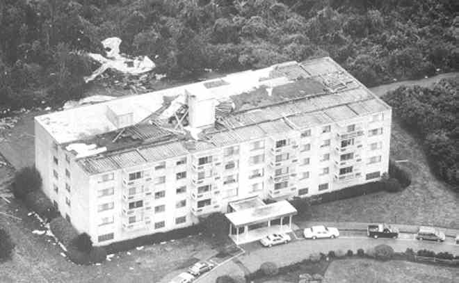
Admiralty Apartments in Falmouth, Massachusetts after section of roof blew off during Hurricane Bob in 1991. (Photo Cape Cod Times-Photographer Steve Heaslip).

Storm Surge flooding in Bristol, Rhode Island during Hurricane Bob. Trees in Photo show edge of harbor. Tides here were 6-feet above normal. (Courtesy The Bristol Phoenix).
Hurricane Bob had a much more significant effect of Rhode Island and southeastern Massachusetts than Hurricane Gloria in 1985. Although Hurricane Bob was well forecast and advance notice of the storm was given - several residents in coastal areas said they were unprepared for the intense winds and storm-surge flooding. Bob also severely hurt the regional tourist and beach economy. As Bob approached the coastline of the Northeastern United States - tens of thousands of vacationers sought shelter in public buildings across southeastern Massachusetts and coastal Connecticut/Rhode Island. The regions extensive boating and commercial fishing industry was also seriously affected.
Tragically, Hurricane Bob caused several fatalities across the region as it passed through. The number of fatalities reported as a direct result of Hurricane Bob stands at 17. Several of those killed were struck by tree limbs. A person photographing a motel roof blowing off in Provincetown, was killed when they were struck by flying debris. At least two deaths occurred on boats during the hurricane - one in eastern Connecticut and one in Massachusetts. The regional power companies estimated that 2.1 million people lost power for more than 24-hours due to the hurricane. Total property damage is estimated at $900 million dollars.
© Michael A. Grammatico 6/02