This site is outdated and is being updated at bangladeshtornadoes.org
I grew up in Lawrenceville in rural southern Virginia. I received a bachelors degree in Environmental Science from the University of Virginia in 1991 and a MS degree in Meteorology at the University of Oklahoma in 1997. I am currently a forecaster at the National Weather Service in Dodge City, KS. I am a tornado enthusiast and enjoy all types of severe storm prediction including tornadoes and winter storms. My present research involves the development of a tornado climatology for east India and Bangladesh, and the documentation of the synoptic and mesoscale severe storms environments leading to tornados in this region.Send a message to: Jonathan Finch
Tornados are no stranger to East India and Bangladesh. Ashraf M. Dewan and I have documented 85 tornados for this region by searching the Pakistan and Bangladesh Observer newspapers back to 1955, and through literary and internet searches. The resulting climatology of tornados for the Bengal region is being published and is copyrighted. Almost all of these tornados (map showing locations of all tornados that killed at least 30 people) occur (julian dates of tornados that killed at least 30 people) from late-March to mid-May and usually move to the southeast or south-southeast.
Nineteen out of 25 (80%) of the tornados that killed 100 or more people, and 32 out of 43 (75%) of the tornados that killed 30 or more people, occurred during the first 20 days of April. Sixteen of the 25 (64%) tornados that killed 100 or more people occurred from April 8 to April 18.
Most of the tornadoes occurred in a relatively small area of central, south central and southeast Bangladesh, or an area about the size of the state of
New Hampshire. The details of each tornado including dates, locations, number of people killed, direction of movement, path width, path length are also provided. The references can be found here.Although East India and Bangladesh are positioned far to the south(21-26N), the regional topography of south Asia makes Bengal more susceptible to violent thunderstorms. The mid-upper tropospheric flow splits around the Tibetan Plateau, allowing the westerlies to be stronger than the zonal average at 24N. Mid-upper level cold pools are steered around the plateau across north India. North India is extremely dry in the winter and spring and a deep mixed layer from the sfc to above 600mb develops south of the Ganges river valley. Daily low-level downslope flow off the mountains of Afghanistan and Pakistan leads to desert conditions during the spring with surface high temperatures ranging from 95-104F on the higher terrain of central India(1500-3000ft) from Bhopal to Ranchi, to 105-120F at low elevations just west of the surface dryline, along with negligible rainfall. When mid-upper level cold pools move across north India, extreme lapse rates are the result. A lee surface low is a daily occurrence on the eastern edge of the 1500-3000ft escarpment around 23-25N and 87E. On some days this low is further south near Jamshedpur while on other days the low is near the base of the Himalayas. North of the low, easterly flow transports moisture westward along the Ganges river sometimes as far west as New Delhi. An excellent example of this is March 20, 1968 when 20 people were killed by a hailstorm in northern India. The 500mb winds were around 80kts that day. To the east of this low pressure area, the low-level flow is out of the south starting in March, bringing moisture laden air from the Bay of Bengal. The sea surface temperatures in the Bay of Bengal remain in the 80-85F range year-round. The southerly flow generally accelerates from March into May. This moisture underruns high lapse rates, leading to explosive instability. Occasionally the mid-level flow becomes strong with 700mb winds from 40 to 50 kts and 500mb winds from 40 to 70kts. Most tornado events in the Bengal region occur with at 50-100kt jet-level winds, 40kt west to west-northwest winds at 700mb, 40-60kt west to west northwest winds at 500mb, along with south to south-southwest flow in the boundary layer and south or east surface winds. There are a few notable exceptions when disastrous tornados occurred with very weak mid-level flow (4-11-64 and 4-13-70). Although the sfc winds increase from March into May, the upper level winds decrease during this time, resulting in a maximum in vertical wind shear in early to mid-April. Surface based capes generally range from 4000-8000j/kg on tornado days and can reach as high as 9000j/kg. Intense thunderstorm activity is almost a nightly occurrence on the Khasi Hills near and around Cherrapunji, and across northeast Bangladesh as the low-level jet impinges on the higher terrain, often resulting in an outflow boundary across northern or central BD. The surface dryline is usually positioned in far east India or western Bangladesh in the spring, and often stretches from northeast to southwest from Rajshahi, BD to Nabadwip, IN to Jhargram, IN to Baripada, IN. Occasionally the dryline pushes east of Calcutta. The sea breeze front along the coast of India from near Balasore to Bhubaneswar is also an important player.
The first documented tornado in the Indian region occurred near Calcutta on April 8, 1838 as documented by (Floyd, 1838).
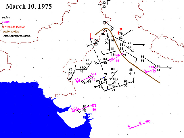
Tornados are not as common in northwest India and Pakistan, but there are a few documented cases. On March 17, 1978 a tornado killed 28 people in New Delhi. On March 10, 1975 10 people were killed near Ludhiana in extreme northwest India. On March 28, 2001 a tornado killed 3 people near Bhalwal, Pakistan. Azmat Hayat of the Pakistan Meteorological Department has provided an excellent synoptic overview of this event. Some of the data shown on the latter map were generously furnished by the Pakistan Meteorological Department free of charge.
I have prepared surface and upper air charts for some of the catastrophic tornado events. Unfortunately, upper air data is very sparse or non-existent across Iraq, Afghanistan, Pakistan for all years, and the former Soviet Union after 1990. Even though India has an extensive upper air network, the quality of the thermodynamic data is low compared to China or Saudi Arabia. Thankfully the wind data over India is good quality. Iran has several upper air sites with decent thermodynamic data, but the wind data is usually missing.
Bangladesh has quite a few surface synoptic observatories and one metar station(Kurmitola in the northern suburbs of Dhaka). The thermodynamic data is usually good. However, I have noticed inconsistencies in the wind data for these stations. Namely, the wind speeds in the synoptic observations seem to be too weak in many instances compared to the metar data at Kurmitola. Oftentimes, the wind speeds at Kurmitola are 2 to 3 times stronger than at the synoptic station in Dhaka, only a few miles away. For example on May 13, 1996, the windspeeds at Kurmitola varied from 16 to 22 kts in the afternoon, while Dhaka only reported 5 to 10 kt winds.
Surface charts(click on date) and upper air charts(click on pressure level) are provided in some of the events where data was available. Surface data were sparse for 1964-1967 and 1969-1973, which unfortunately correspond to very active tornado periods in Bangladesh.Since the upper air data is not in a format recognized by available software, I manually plotted each data point by hand using the software program "MSPAINT".
04-07-1888 Tornadoes hit Dhaka and Rajbari, killing 118 and 70 people respectivelycredit Pedler and Crombie, 1888;
Petersen and Mehta, 1981
03-19-1961 Tornado hits Dohar, Jhaukandi and Nawabganj, killing 210 people. credit Bangladesh Observer
04-19-1963 Tornado hits the West Bengal and Assam states of India and clips extreme northern Bangladesh, killing 139. credit Nandi
and Mukherjee, 1966
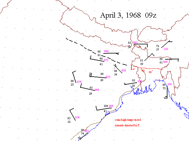
04-03-1968 Tornado hit near Begumganj in southeast Bangladesh, killing 42 people credit Pakistan Observer
04-11-1968 Tornado hit Naria and Bhederganj, Bangladesh killing 141 people credit Bangladesh Observer
04-14-1969 Tornadoes hit Dhaka and east of Dhaka, killing a total of 923 people credit Bangladesh Observer
04-17-1969 Three tornados result in 84 deaths in central and western Bangladesh credit Bangladesh Observer
04-29-1972 A tornado kills up to 300 people in northeast Bangladesh credit Bangladesh Observer
04-01-1977 Tornado hit Madaripur in southern Bangladesh killing 500 peoplecredit Bangladesh Observer
04-16-1978 Tornado hit near Anandpur, India killing 173 people credit Ghosh, 1982
04-18-1978 Tornado hit near the Bangladesh-India border in India killing 128 people credit Petersen and Mehta, 1995
04-12-1981 Tornado hit extreme southeast Bangladesh, killing 200 people credit Bangladesh Observer
04-17-1981 Tornado hit near Patna in coastal east India. Death tolls range from 40 to 120 credit Singh, 1985
04-12-1983 Tornado hits northeast of Calcutta in extreme east India killing 50 people credit Amritz Bazaar Patrika newspaper
04-14-1986 Tornado kills 100 people in southern Bangladesh credit Journal of Meteorology(British); Bangladesh Observer
04-26-1989 Tornado hit Saturia in central Bangladesh, killing 1300 people(credit Tom Grazulis) 500mb
04-20-1990 Tornado hit about 50 miles northwest of Dhaka, killing 76 people credit OFDA/CRED disaster database 500mb
05-07-1991 Tornado hit north of Dhaka near Gazipur, killing 45 people credit Ono, 1997; Bangladesh Observer 500mb
05-18-1991 Tornado hit in southern Bangladesh near Gournadi, killing 50 people credit Ono, 1997; Bangladesh Observer
04-09-1993 Anticyclonic tornado near Kandi in extreme east India kills 145 people credit JOM(British); Misra et al., 1996-
Indian Meteorological Department 500mb
04-08-1995 Tornado hits Munshiganj district of central Bangladesh, killing at least 40 people credit Minneapolis Star Tribune;
OFDA/CRED disaster database; JOM(British) 500mb
05-13-1996 A family of tornadoes moved south-southeast at 25 mph across northerncredit Ono, 1996; Vasquez, 1997
and central Bangladesh, killing over 600 people 500mb
03-24-1998 Tornado hit near Dantan in coastal east India, killing 250 people(credit Associated Press) 500mb
The publication "Significant Tornadoes" by Tom Grazulis references a tornado on April 28, 1989 in India that killed 10 people at a missle launch site.
I have been unable to find any details at all about this tornado. Based on the upper air data--500mb and surface observations, the most likely place would be just south of the Himalayas in northeast India around 26.5N and 90E. I welcome any details anyone has concerning this tornado.I purchased the data for these maps from the National Climatic Data Center and the National Center for Atmospheric Research. The Indian Meteorological Department provided some of the data as well. Rafique Ahmed from the University of Wisconsin supplied supplementary data for May 13, 1996. More data exists than is shown on these maps. For example, surface data is collected for Faridpur, Mymensingh, Rajshahi, Dinajpur...etc, but the Bangladesh Meteorology Department will not release these data. The Indian and Pakistan Meteorological Departments were very friendly and provided extra data for certain cases. They respond quickly to email or regular mail.
This spring (2003), I will begin making daily forecasts of tornados from March 1st to May 15th as long as time permits. I plan to update the forecasts daily between 16Z and 00Z GMT(10 pm and 6 am BST) as time permits. An outlook will consist of a map and risk area(high, moderate and slight) for supercell storms/tornados. A forecast discussion will also be prepared.
These links are under construction:
Day 1 outlook
Day 2 outlook
Days 3-7 outlook
forecast discussionSurface maps and upper air charts may be posted whenever possible during active periods and time permitting. Please note that such maps can be easily generated with Digital Atmosphere. This is a fantastic graphical program that retrieves meteorological data from the internet and displays these data on customizable maps for anywhere on the globe. This program ingests data from some of the links below including College of Dupage and Albany.
Upper air
University
of Wyoming - historical dataset back to 1989
Albany
- real time
College of Dupage
Weather Underground of Hong
Kong
NCEP/NCAR
global reanalysis
Surface data
Albany
- real time
College of Dupage
Weather Underground
Satellite
NASA -
IR
NAVY -
IR
Indian
MET IR
Indian
MET visible
SSEC - IR loops
Model links
Meteostar
- mrf sw Asia
![]()
