

iRiphabliki
wase Ciskei
Republic
of Ciskei
The arms of Ciskei, registered by the State Herald in Pretoria and published in the South African Government Gazette on 8 September 1972, may be blazoned:
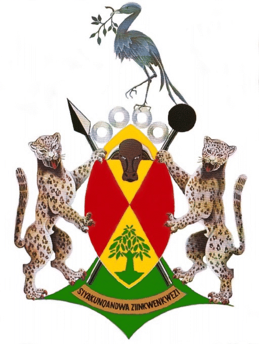
Arms: Upon a Nguni shield per saltire or and gules, in chief an ox-head caboshed proper, in base a milkwood tree on an island vert. Behind the shield a spear and a knobkierie sable in saltire.
Crest: Four ivory rings conjoined, standing thereon a blue crane holding in his beak a sprig with nine leaves proper.
Supporters: Two leopards rampant gardant proper.
Motto: Siyakunqandwa ziinkwenkwezi.
Arms explained:
The shield is a typical Nguni shield, the shape found also in the arms of Gauteng, KwaZulu, KwaZulu-Natal, Gazankulu, Botswana, Tanzania and Kenya. The Xhosa – the southernmost of the Nguni peoples – have not used shields in war for over a century, but formerly used large cowhide shields roughly the height of a man. The only shields still in use among them are stick-fighting shields, made to the same pattern, which are only some 300 mm across. Stick-fighting is the traditional exercise of young men in the rural areas.
The ox-head not only points to animal husbandry as an important economic activity among the rural Xhosa but underlines the significance of cattle-keeping in their traditional culture, as well as symbolising wealth. Cattle are significantly important in traditional ceremonies. It is also said to symbolise the development of society.
The ox-head is also a specific reference to the Xhosa prophet Ntsikana (died 1820), who preached an indigenous form of Christianity to the amaXhosa in the first two decades of the 19th century. Among his herd was a favourite ox. Ntsikana prophesied the arrival of the settlers, their religion and their money.
The British settlement scheme of 1820 (which placed settlers in the Albany district, west of the Fish River) brought profound changes to the lives of the Xhosa. The Christian Faith – acceptable to the Xhosa thanks to the influence of Ntsikana – would make the other changes, such as the introduction of a cash economy, more bearable.
The milkwood tree, also called umqwashu, is of particular significance to the Mfengu people. This type of tree – the white milkwood (Sideroxylon inerme) – grows in the Peddie district, and it was there that the amaMfengu gathered under a particular umqwashu on 14 May 1836, under the guidance of Methodist missionary the Rev John Ayliff, and entered into a covenant to show allegiance to God, to educate their children and to be loyal to the Government. Every year the Mfengu gathered under the umqwashu to renew this covenant.
The tree is held to symbolise the authority without which the people cannot create a prosperous future. Despite a report that this particular tree had been cut down, Tony Dold of the Selmar Schonland Herbarium at Rhodes University informs me that it is still flourishing. This picture demonstrates this.
My earlier informant speculated that the “destruction” of the tree had possibly been the work of Xhosa activists wanting to minimise difference between the peoples of Ciskei.
The weapons behind the shield represent chiefly authority. The spear – usually incorrectly blazoned as an assegai – is a metal-bladed weapon made by traditional smiths who spring from an ancient tradition of digging out metal ores and working them. The assegai is a short stabbing spear introduced in the Zulu kingdom by Shaka; the peoples of Ciskei retained the tradition of a longer throwing spear. The knobkierie (which might be called a long-handled shillelagh) is found universally in Southern Africa – among Bantu-speaking peoples as well as among Khoikhoi – as both a weapon and a symbol of authority.
The ivory rings (in the crest) are traditionally worn on the upper arm by chiefs; there are four, one for each of the tribal elements in the Ciskeian population: amaXhosa, amaMfengu, abaThembu and Basotho. The rings are described as being conjoined, but in fact the lie side by side.
The blue crane (Anthropoides paradisea, also called Stanley crane) is a bird very special to the amaXhosa, who call it indwe. When a man distinguished himself by deeds of valour, or any form of meritorious conduct, he was often decorated by a chief by being presented with the feathers of this bird. After a battle, the chief would organise a ceremony called ukundzabela – a ceremony for the heroes, at which feathers would be presented. Men so honoured – they wore the feathers sticking out of their hair – were known as men of ugaba(trouble) . . . the implication being that if trouble arose, these men would reinstate peace and order.
It is ironic that a town called Indwe lies close to the north-eastern boundary of Glen Grey (later renamed Cacadu), which was part of Ciskei until December 1975. Perhaps even more of an irony is that the blue crane is the national bird of South Africa. Yet South Africa under apartheid rule registered not only these arms with the blue crane crest but also a Ciskeian flag that incorporated a blue crane.
The crane holds in its beak a sprig with nine leaves, which represent the nine regional authorities that made up Ciskei until the end of 1975 – Hewu, Keiskammahoek, Middledrift, Victoria East, Mdantsane, Peddie and Zwelitsha. The kind of tree the sprig comes from is not mentioned.
The leopards (Leo pardus) also represent chiefly authority: it is traditional in Southern Africa that only chiefs may hunt leopard, and only chiefs or those deserving of special favour may wear leopard skin. The whole skin is especially reserved for chiefs: when a chief is installed, a leopard skin is draped over his shoulders.
The chairman of the Ciskeian National Assembly wore a leopard skin as part of his ceremonial gown.
The leopards are gardant – they face the viewer and can be held to guard the nation. Bophuthatswana also had a pair of gardant leopards for supporters, while the supporters of Transkei’s arms were leopards that were simply rampant, not gardant.
The motto, Siyakunqandwa ziinkwenkwezi, which translates as: “We shall be stopped by the stars,” or “The sky’s the limit.”
Languages and people:
The name Ciskei indicates that it is the home of people living “this side” – towards Cape Town – of the Kei River. The republic invariably spelt the name Ciskei, although it should strictly have been written Siskayi in Xhosa. This was partly because Kei is not a Xhosa name – it is Khoisan; the Xhosa call the river Nciba.
The name amaXhosa belongs, strictly speaking, to the nation which regards itself as being descended from an eponymous ancestor called Xhosa: the amaGcaleka of Transkei, and the amaRharhabe of Ciskei (who are further divided into a number of smaller groups).
The name Xhosa (isiXhosa) is, however, also given to the written South Nguni language, which was first written down by missionaries among the amaXhosa. (It was the very first of Southern Africa’s Bantu languages to acquire a written form.) So when the term is used linguistically, it embraces not only the amaXhosa, but also the amaMfengu, the abaThembu and the rest of the Nguni-speaking peoples of Transkei.
The amaXhosa who live west of the Kei first settled their lands about the time of Jan van Riebeeck’s foundation of the settlement at the Cape. In this sense they are the most recently settled of the abaNguni. But they were also the first to be conquered by the British, and so have a longer history than any other Bantu-speaking society of being under colonial rule, and a longer exposure to Christian missions and to Western education. This is even more the case with the amaMfengu (see below).
Ciskei is home to a number of well-known educational institutions, notably Fort Hare University (founded in 1916 as the South African Native College), which at some stages of its history was the only tertiary institution open to black students in the whole of Southern Africa. It boasted students from as far afield as Northern Rhodesia (Zambia) and Uganda.
It is because of this that Xhosa-speakers were among the leaders of resistance to apartheid, and to the homeland states themselves. In both Ciskei and Transkei, conservative, chiefly administrations were installed partly because the more radical elements in the population refused to exercise their vote and preferred to support the national resistance movements.
During the 1820s a new element was added to the population of the region around the Kei River when clans of abeNguni who had fled from the Zulu kingdom arrived in the Trans-Keian district of the amaGcaleka. (These included groups from both north and south of the Thukela [Tugela] River.)
When they were asked by the Gcaleka chiefs who they were, they replied: “Siyamfenguza” (“We are hungry people.”) From this response they were then called amaMfengu (“hungry people”). The colonials later called them Fingo.
They were allowed to settle in the north of the Gcaleka district, in the upper Gcuwa River valley, but although they were allowed to cultivate crops, they were forbidden to keep cattle – a humiliating condition. Nonetheless, the men of the amaMfengu were the first male Bantu-speakers in Southern Africa to become agriculturalists.
Missions took root among them early, too, the Butterworth mission being founded in 1827.
They were the first black South Africans to use ploughs. Other firsts followed: in 1865 they were the first to plant wheat, and in about 1870 the first black sheep farmers.
Because of their subjection among the Gcaleka, the Mfengu allied themselves with the British in time of war and were rewarded with land – they were confirmed in their possession of Fingoland (the upper Gcuwa valleys), and also received parcels in the Ciskeian territories. They first settled in the Peddie district in 1836, and later occupied other parts of what became the Republic of Ciskei, as well as land further west, as far as the narrow coastal strip of the Tsitsikamma.
The tribal lands west of the Kei were first brought together under British rule as part of the short-lived Province of Queen Adelaide (1835), and then in the colony of British Kaffraria (with its capital at King William’s Town), which existed between the Fish and Kei rivers between 1847 and ’66 before being annexed to the Cape Colony.
By the time of Union (1910) the Ciskeian Territories comprised tribal trust lands (in the Cape Province) between the Fish and just east of the Keiskamma, stretching northwards to Keiskammahoek; the south-western part of the Queenstown district; the district of Glen Grey (north-east of Queenstown); and the Herschel district, between the Orange River and the Drakensberg range.
However, close ties between the abaThembu of the Glen Grey district (called the Emigrant Tembu in colonial terms) and the rest of the Thembu people (in Transkei) led to the transfer of both Glen Grey and Herschel to Transkei, shortly before that homeland’s independence in 1976.
Large numbers of tribesmen from both Herschel and Glen Grey (Xhosa, Thembu and Sotho) refused to be incorporated into Transkei, and accepted transfer to the Queenstown district, where the trust lands became the new district of Hewu. To consolidate Ciskei, not only was Hewu enlarged, but the district of Stockenström (lying between Hewu and Keiskammahoek, and named for Sir Andries Stockenström) was expropriated from the white and coloured farming families that had lived there for some 130 years. White-owned farms in the Peddie district were also expropriated. Fingo and Xhosa were also expelled from their homes west of the Fish River and forced to settle in Ciskei. This was to cause particular hardship for the small numbers of Xhosa from the West Coast, as well as a community from Riemvasmaak, north of the Orange River, who spoke Afrikaans and found it hard to adjust in a Xhosa-speaking society.
Urban townships were developed outside East London (Mdantsane) and King William’s Town (Zwelitsha) during the 1960s. By the 1980s the population of Mdantsane was so large that it exceeded East London in size, and it was referred to at “the largest city on the Border” by the East London newspaper, the Daily Dispatch. Both of these developments were incorporated into Ciskei. (The Border region lies between Ciskei and the Kei River, from East London in the south to Queenstown in the north. It was so named when it was the eastern frontier of the Cape Colony, and the name is still in use today.)
The “independent” state:
The Ciskeian Territorial Authority chose in 1982 to accept South Africa’s offer of independence, and on 4 December that year it became the Republic of Ciskei.
This independent status was, however, not recognised by any country outside South Africa, and the best international recogition Ciskei or any of the other three “independent” states received was the listing of their postage stamps in the Stanley Gibbons catalogue. Throughout its existence Ciskei relied heavily on subsidies from South Africa, and the four “independent” states exploited the South African Government’s anxiety by inflating their budgets with salaries for excess staff and exorbitant expenditure on the leadership and their spendthrift projects, such as the “international” Bulembu airport near King William’s Town.
Ciskei also built a large and rambling capital at Bisho, just north of King William’s Town.
Ciskei benefited from South Africa’s “border industries” policy under which factories were sited either on South African territory, close to the homeland state, or within the state. Large numbers of Ciskeians were employed in these industries, situated chiefly in the Border corridor – in and near East London (including Berlin), King William’s Town, Stutterheim and Queenstown – as well as in Ciskei at Dimbaza. Post-apartheid economic policies (such as the removal of subsidies to the operating companies) have seen many of these factories close.
Like the other three “independent” homeland states, Ciskei ceased to exist on 27 April 1994. It now became part of the Eastern Cape Province, of which Bisho became the capital.

Vir Afrikaans, kliek hier
Comments, queries: Mike Oettle