
We'd like to hear from you. Got a picture of your group at the top? Comments about the site? Pictures of animals on the trail? How was your hike? Let us know.
Hike description Slide Show The Five of Us Our Thoughts Links Pictures and Comments from other Hikers Contact Us
Mount Whitney Trail
Mt. Whitney is the highest (14,505 feet) peak (see note at end for details about altitudes used in this site) in the lower 48 states. The trail to the top is 10.7 miles long and has a total elevation gain of about 6000 feet. For most people that make the hike to the top of Mount Whitney in one day it will be the most difficult physical activity of their lives. On September 14, 2005 five friends from Southern California made the hike to the top of Mt. Whitney from Whitney Portal (8,360 feet). This is a description of the hike and a collection of some of their thoughts about it. Check out the slide show for some more details.
We quickly packed up the camping gear from Whitney Portal campground where we had stayed, ate a small breakfast and arrived at the Whitney Portal trailhead by 5AM.
Trailhead to Mirror Lake (4 miles, 30 minutes per mile)

Trail Head (the night before)
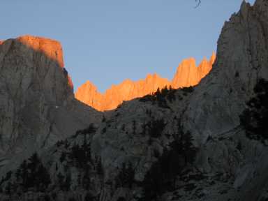
First Light on Whitney from Near Mirror Lake
This section of the trail is a steep series of switch backs on fairly smooth ground. We used LED flashlights on most of this part of the trail. Michelle led the way and set a strong pace that was on the edge of what I (Dave) could sustain. We completed the first mile to the John Muir Wilderness sign in 24 minutes. We finished the whole section of the trail in about two hours. The altitude gain was 2,280 feet (570 feet per mile). We passed about 15 people on this section of the trail that had started a little earlier than us.
Mirror Lake to Trail Camp (2 miles, 37.5 minutes per mile)
This section of the trail rises from 10,640 feet to 12,000 feet (680 feet per mile). The trail is rocky and the footing is often a little unstable. Fortunately, the sun had risen enough by the time we reached Mirror Lake that the flashlights were no longer necessary. Charlie, Michelle and Steve completed this section of the trail at almost the same pace that they had begun the hike at. Michelle commented that she thought that this section might have been easier than the first section. Exactly why is a mystery to me. It’s steeper, rockier and higher but maybe people who have run half marathons view the world a little differently than the rest of us. Meg and I made it to Trail Camp about 15 minutes after the rest of the group.
Trail Camp is the last place to camp on the trail to the summit. It is roughly a large rock bowl with an unnamed small lake that can be used as a source of water. The water is very clear but also highly suspect given the close proximity of many campers and the propensity for the obvious to flow down hill. The area was dotted with several tents that were pitched mostly along the edges. We stopped at Trail Camp for about a half-hour while we filled up our canteens and took pictures. For the first time since I had begun preparing for this hike 7 weeks previously, I was pretty sure that I would make it to the top. Charlie took this moment to confide that he wasn’t sure that he would make it to the top. This was mildly unsettling since if there was one person in our group that I was sure would make it to the top it was Charlie and if there was the remotest chance that Charlie wouldn’t make it then I wasn’t making it for sure. Meg had suffered some mild effects from the altitude on the climb up to Trail Camp and decided to take a pill for altitude sickness during the break.

Trail Camp

Trail Crest (Steve and Michelle)
Trail Camp to Trail Crest (2.2 miles, 47.7 minutes per mile)
The trail winds it way up from Trail Camp to Trail Crest in a series of steep and rocky switchbacks. This section of the trail is reported to have 96 switchbacks but at least one source reports the actual number as 140. Whatever the case, I was in no mood to count them. It is a tough long climb and for the first time on the trip I noticed that the altitude was beginning to significantly slow me down. Meg and I began the climb to Trail Crest at about 9 am and finished it by about 10:30. The rest of the group had gotten there about 15 minutes ahead of us. We stopped to eat a little lunch. I was surprised that I wasn’t hungry. I had thought the extreme physical exertion would have driven large appetites and had packed food accordingly. In fact we ate very little. Apparently either the altitude or the exercise was working to curb our appetites. Altogether on the trail from Trail Camp to Trail Crest we gained 1777 feet in 2.2 miles (807 feet per mile).
Trail Crest to the Top (2.5 miles, 60 minutes per mile)
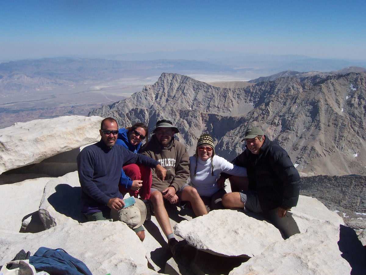
This section starts at 13,777 feet and finishes at the 14,505 foot peak of Mt. Whitney. The altitude gain is only 719 feet (287 feet per mile). The trail is much tougher than this small altitude gain would suggest. Besides the fact that the trail is very high it actually goes down in places so the total altitude gain is actually quite a bit more than the net altitude gain. The most difficult section of the entire Whitney hike doesn’t happen until the last half mile. At this point the trail rises from 14,000 feet to 14,505 feet (992 feet per mile). The trail is rocky with numerous places where the footing is unstable. We left Trail Crest at about 11am. Meg and I were a little slower than the rest of the group. For the first 1.5 miles Meg and I hiked at the rate of about 40 minutes per mile. With about one mile left I began to slow a great deal. Each step seemed to cause mild chest discomfort. Meg was substantially stronger than me during this section. Eventually we transferred most of the weight out of my pack into Meg’s for the last half mile or so of the hike to the top. Meg and I made it to the top at about 1PM. The rest of the group had preceded us by about a half hour. I was truly euphoric to take that last step and see the rest of our group.
We spent about an hour at the top. It was a very pleasant day up there with a only a small wind and a temperature that was probably in the fifties. We enjoyed the views, took some pictures and talked with a few of the other people that had made it to the top. One group of hikers had made it to the top in about four hours. Needless to say these guys looked fit. At 56 I was amongst the oldest to have made it to the top that day although there were several people I judged to be somewhat older. At twenty or so pounds overweight I was almost the most overweight person to make it to the top that I noticed. The one exception was a fellow that looked to be about 60 who seemed to be a little more overweight than I was. We had passed him on the trail a few miles back. At the time we passed him I was pretty sure he wouldn’t make it to the top but I was wrong. He got to the top about a half hour after we did and immediately headed down. He was obviously in significant discomfort.
The Hike Down
We began the hike down at about 2 pm. We passed several people on the way down. Given their speed it looked like they were going to finish the hike well after dark. Meg and I reached the trailhead at about 7:30pm. The rest of the group had reached the trailhead by about 7pm. Everyone was in pretty good shape. Both Meg and I have had previous knee injuries that were made a little sore by the downhill. Michelle suffered a little nausea, but Charlie and Steve made it through unscathed and still feeling pretty good.
With more info and some nice pictures
 |
|
Low resolution slide show (1024 x 768
or higher)
High resolution slide Show (1680 x 1050 or
higher)
| The Five of Us |
Steve - 47 years old
Michelle 42 years old
Charlie – 34 years old
Megan – 21 years old
Dave – 56 years old
|
Why Did We Go?
Charlie
I have always wanted to do it but really had no idea what it was like. So, when Steve had mentioned he knew someone that was doing it and that we could tag along I actually was reluctant to give a yes for sure. Right away I thought there wouldn’t be enough time to build my endurance because it was going to be a loooong day at 22 miles. I mentioned this one day adventure to my nephews Boy Scout troop on a campout I accompanied and learned that several of his troop members had done it the year before, took 4 days, and did it with backpacks. I told them we were going to do it in one day and they were trying to convince me to try it in a couple days or more but…We were tuffy guys and doing it in one day. Also, a couple different people that had done it compared it to a marathon and said it was harder. Well, I haven’t ever done a marathon so….????
Michelle
Well, it started with me teasing Steve about not inviting me on his all guys
trip. Of course there is also the competitive nature Steve and I have with
each other. He wasn’t sure I was in good enough shape…. HA!
We’ll see about that! When an opening came up and he called my bluff, I
had to decide if I really wanted to do this. I was probably in the worst
shape of my life, had gained a lot of weight, and would have to arrange rides
and sitters for the kids and their school/activities for 3 ½ days.
I was also concerned that I would be too worn out after the hike to do the MS
Society 100 mile bike ride I had committed to do 10 days later. I
rationalized that it would be good training for the bike ride.
Steve
I had always wanted to hike Whitney just because it's the tallest mountain in the lower 48 states. I also felt a little guilty speeding past it on 395 on numerous trips to Mammoth and points north and thinking "I still haven't climbed Whitney yet". It was never much of a priority though, mostly because I thought it would be a hassle to get the required permits. Also, I knew it would be crowded and, since one of the main reasons I backpack is for quiet and solitude, I wasn't particularly anxious to go. That changed in July when a friend's husband invited me to go on a full moon hike up Whitney as he was training to climb Mt. Kilimanjaro. He described how scenic it was and volunteered to go up early and get the permits. How could I say "no"? The only problem was that I had invited a few friends and was surprised that they all wanted to go! Not to mention my wife, whom I had no idea would want to go. I was a few people over the limit of five (the number of permits an individual can reserve), and there were no open spaces to be reserved for the night we planned to leave. It meant I would have to risk not getting a permit as well as trying to decide who to leave behind. Fortunately, Dave rescued the plan and volunteered to go up early and get all the passes for a reconstituted group of five. Even better, by advancing the date a few days, there were vacancies and we were assured permits. As the time drew closer, I became more excited about the prospect of the climb. Even as Chuck kept on about how difficult it would be, and how two out of every three people who set out don't make it to the summit, even when I learned that the outhouses were out of order and that hikers were issued poop bags to pack it out, even then I was anxious to go.
Megan
I had wanted to do this hike for a long time. It felt important to
challenge myself and to do something that I
could look at as a mark of achievement in my life. Since I pretty much
skipped out on the competitive sports gig
now it seems somewhat important to at least be competitive with myself; to push
just a little bit harder.
Dave
It is easier to talk about why I wasn’t going to go. For two or three weeks after Steve suggested the trip I had no intention of going. I had made the hike once previously when I was thirty pounds lighter, eighteen years younger and in much better shape and it was still the most difficult thing that I had ever done of a physical nature. So making the hike at this point in my life seemed pretty crazy. I am not sure what changed my mind. I was curious about how my body would respond to six weeks or so of training to prepare for the hike. It also seemed like it might be a good incentive to lose some weight. Since about the age of 45 my weight had gradually climbed and I had never been successful at reversing that trend. Plus there was the nostalgia thing of returning to the place that I had been so many years ago with my brother and finally my daughter and I had discussed making the hike for several years and if we were ever going to do it this was probably the time.
What we did to prepare
Charlie
After being convinced of going I began to learn more about Mt. Whitney mostly through the internet then later purchased a book for more details. Now was the time to become a little intimidated by the facts I was learning. For example, the altitude being as high as is was and the fact that of the 25000-30000 people a year doing Mt. Whitney, 1 in 3 people weren’t making it to the top and mostly due to altitude sickness. I have only had minor side affects to altitude sickness in the past and just became aware that I had altitude symptoms only after reading about them in the book. Did I do more to prepare physically for it-nothing more than playing racquetball 2-3 times a week up to 4 hours at a time. Mentally preparing was just being used to long days or trips already experienced on past hiking trips and remembering feeling stronger as the days went by. No instant gratification here this was going to feel like it is never going to end…..
Michelle
I didn’t do any research. I knew Steve and Charlie would do enough
for all of us and fill us in. Besides if I knew the specifics, I
might find out that it was harder than I expected. I decided to be
surprised.
I had started training with my friend Jackie for the Multiple Sclerosis bike
ride over the summer. We would jog 4-5 times a week and got up to 5
miles. We also rode our bike each morning and jogged each
evening while on vacation in August. The last 3 weeks I got back into
weight training, concentrating on leg power in anticipation of those 97
switchbacks in a row I had heard about. This included lunges,
squats, and treadmill interval training on a high incline.
Steve
I didn't do much specifically to prepare for Whitney but I felt pretty good about my prospects because I had done two backpacking trips over the summer. Two weeks before the hike, Charlie and I hiked up to 10K feet carrying 50 pound packs. I figured if I could go five miles uphill with 50 lbs, I could handle 11 miles up hill with a day pack weighing only 10 lbs. I also packed up to Nevada Falls in Yosemite a month earlier, and that trail is very steep in spots. Dave did invite me to go jogging one day when it was about 95 degrees out, but other than that I didn't really run much. I did try to make sure that I was fully hydrated before the hike and planned to take my water filter and plenty of water on the hike up.
Megan
I walked with my friends when I could. I went on a small backpacking
trip to Mount San Jacinto, this was good as a
tester for my abilities. After I got back from that I fake-joined a gym
(i.e. one week trial). I stepped up the
exercise quite a bit by going to the gym for at least an hour every day that
week. The thing that probably helped
the most was working the treadmill at full incline while watching episodes of
"Lost", the most addictive show of last season.
Dave
I was easily the person in the group that was the most out of shape and the most overweight (5'9" 208 pounds). I knew that making it to the top would require significant preparation. In the seven weeks prior to the trip I ran about twenty five times. Most of the loops I ran were about three miles. On occasion I increased that to about five miles. In addition, I got in some walking, a little weight lifting and some mountain bike rides. Also my daughter and I spent four days hiking just prior to Whitney hike. My goal was to get down to 195 pounds just prior to the hike. I think I might have made it. I was about 200 pounds when Meg and I left for the Sierra. After four days of hiking I think I was pretty close to 195 pounds when the Whitney hike started. I was down to 192 pounds on the day after the hike.
What we did to acclimatize
Charlie
The only elevation acclimating was on a 4 day backpacking trip a couple weeks before with Steve that honestly didn’t seem to strenuous even though it was all up hill on the way in and 5 miles. We camped at 9,000 and 10,000 feet but I later learned that the elevation acclimating wouldn’t last until our Mt. Whitney trip so no benefit for that just the hiking part would benefit us. Steve, Michelle, and I camped at 10,000 feet two nights before then at the trail head after meeting Dave and Megan the night of hoping that any time at elevation even a couple days would help.
Michelle
I went to my doctor to get a prescription for preventing altitude sickness.
The only other time I could recall being higher than 11,000 elevation was also
the hike I got sick. He prescribed Diamox, along with reading the
huge list of side effects. Steve, Charlie and I camped at
Steve
Megan
The backpacking trip I took may have helped, but it was two or three weeks before
so maybe any positive effects had worn off. Mostly, the hiking and the camping I did with my dad seven days prior
to our ascent was what helped. I think acclimatization is partly just getting the idea that you have to move even if it
hurts. Those first few days you just don't want to, but then you're thirsty so you walk to the lake. This
doesn't kill you so you move on. Plus, at trail camp I took a Diamox pill. I do not know to what extent this
helped, but I did have less altitude symptoms after taking it.
Link to discussion of altitude sickness including discussion of medications
for altitude sickness:
http://www.traveldoctor.co.uk/altitude.htm
Dave
The first time I made the hike, my brother and I went from sea level to spending one night in Lone Pine on the night before the hike to doing the hike the next day. We both suffered very painful altitude induced headaches. I really wanted to avoid that. So this time we spent quite a bit of time acclimatizing to the altitude before the hike. My daughter and I did a little backpacking where we slept at over 10,000 feet , we stayed in a high cabin (over 7500 feet) and we camped at a Whitney Portal on the night before the hike to try to acclimatize to the higher altitudes. Several sources that I saw reported that acclimatization requires 1-3 days. For me the number seems to be about three days. On the first day, I had mild headaches and my aerobic capacity was severely limited at around 10,000 feet. By the second day, the headaches were gone but my aerobic capacity was still severely limited to the point that I thought the Whitney hike might not be possible for me. On the third day I woke up with a completely clear head and found that I was nearly at full strength despite being at altitudes over 11,000 feet.
Would We Do It Again?
Charlie
Yes, I would but would like to try some other way. Meaning, I would either try it in less total time on the same trail or try another more challenging route. I remember feeling more worn out doing Yosemite Half Dome the two times than doing this. I felt guilty for not having any aches or pains or altitude sickness having read so much about others who have suffered. I felt too good! So, on the last couple miles out I started to pick up the pace and actually began running until catching someone and slowing down to a fast walk nearing the end.
I have only one minor regret from this trip but most important was that this trip was one of the best ones ever because of the great company of friends I was with and we were able to stay together and enjoy as a group.
Michelle
Only if we went up a different trail. Although, there are so many other
trails to explore, I’d prefer going on a trip with a warmer climate and more
green scenery... I was miserably cold most of the hike up and down.
I wouldn’t care for camping anywhere on the trail we hiked. It was open
rocky land, no restrooms or privacy to make your own, no fires, not much
greenery, not much soft ground to set up a tent, mostly rock., and very windy.
Steve
Megan
I think I would if someone I knew wanted the experience, but otherwise I
would skip it. There's a great big
wilderness out there for me to explore. Think of all the national parks
you've never been to; all the hikes we've
never done. Hiking should be about challenging yourself, but also about a
thousand other things which you should weigh when deciding where to go.
Dave
I was pretty sure I would never do it again after we had made it down from the peak to Trail Crest. My knee was sore, my legs were very tired, the altitude was still significantly affecting my strength and we had more than eight miles to hike down some of the most rugged trails in the High Sierra Mountains. Now, I’m about 50-50 on the question. If I did it again, I would want to be down to something around 175 pounds. I would not want the final pitch up to the peak to be nearly as hard as it was for me this time.
Most memorable moments
Charlie
First, was the unique trail head structure, why??? Second, beginning the hike in the dark—no moon and seeing the day slowing brightening up. Third, would be rounding that corner and seeing the golden peaks lit so magnificently by the morning sun and Dave included the picture on this page (you had to be there). Forth, would be feeling really good and energized up until Trail Camp and probably due to the fact that the temperature was still low around 45-50 so it wasn’t too hot. As a matter of fact, the weather couldn’t have been better for this trip or any trip with sunny skies and not a cloud could be seen, really, we were at the top of the world. Fifth, the bathroom structure at Trail Camp. I have never been hiking on a trip like this and remember a super bathroom with solar panels and Biohazard labels. Sixth, would be the feeling at the top of Trail Crest. Wow, the views were spectacular. I had no idea what to expect and was awesomely surprised and at the same time a little afraid of heights due the sheer drop offs to either side. Coming up to the 4 Witches peaks and looking through was frightening too. A windy day would be hell for someone afraid of heights. The temperature read 40 in the shade on my little thermometer and was only slightly breezy. Seventh, running into someone from Europe that sounded exactly like Arnold Schwarzenegger. He had bells jingling along the way because he thought we had grizzly bears and new to make noise to let them know he was coming. He was cool and funny with a great attitude on his way down from Mt. Whitney full pack. Eighth, would be seeing that famous hut at the top and knowing that I had made it. Ninth, would be trying to sign my name and information in the log book and having trouble because of being cold and quite possibly swollen fingers from the altitude. Tenth, seeing a Marmot attacking someone’s backpack trying to get his food. Funny! Eleventh, of course the views from the top.
Michelle
Good ones or bad ones? The best moments for me were:
Seeing the sun rise through the peaks as we climbed the first 4
miles. Sitting up at Trail Crest looking down at the lakes, and seeing
Dave and Megan reaching that point. The last part of the hike,
climbing the red rock and seeing the view through the 5 windows. The
scenery looked like something out of a Star Trek movie on some uninhabited
planet. The worst moments were all on the way down: The
feeling of nausea and a headache with 9 miles left to go. Having to
go sooo bad during the decent of the 97 switchbacks, with no place to squat.
Realizing that Charlie had fibbed about how many miles we had left 2 miles back.
UUUghhh. And lastly, opening the car door to lose
it, while waiting for Dave and Megan to finish. (And losing it again at
the restaurant, and at the gas station half way home).
Dave
All the things that Charlie mentioned were memorable moments for me but the one that stands out is the feeling of elation after making it to the top and seeing the rest of our group. This was the stand out moment for me.
Megan
I always have an amazing time chatting with my papa in the woods. Other highlights include going to Manzanar the day before. For anyone who hasn't been recently I really recommend it. Rarely do we see our government so freely admit a mistake we've made and somehow this memorial has managed to do so in a beautiful way. There's always something special about seeing the human ability to create something beautiful even under great repression. Also forgetting my shoes at Manzanar and having to drive an extra forty miles was pretty memorable. On the actual hike, I would love to say some gorgeous view, but alas it was having to pee at trail camp where your only shelter is open air.
Note on the source of the altitude values used in this site
All the altitude and distance values are based on information from a
topographical map made from the Mt. Whitney and the Mt. Langley quadrangles
except the actual height of Mt. Whitney itself. The source for this is
USGS data from this site: http://www.peakbagging.com/SPS BM/GT1811.txt
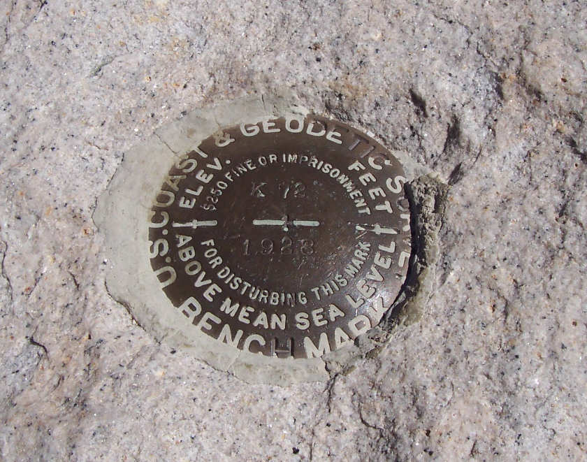 Details about USGS benchmark located at the peak Details about USGS benchmark located at the peakhttp://www.peakbagging.com/BM%20Data/CA.TXT |
Orange County Register article about another trip to Mt.
Whitney
http://www.ocregister.com/ocregister/news/local/sanclemente/climbingmtwhitney/article_1654215.php
Short history of the trail and the Smithsonian House at the
top
http://www.lonepinechamber.org/history/whitneyhist2.html
Mt.Whitney Trail Wikipedia
http://en.wikipedia.org/wiki/Mount_Whitney_Trail
You can contact Dave with any questions or comments you might have about the Mt. Whitney trail or this site.
davefoc@gmail.comHike description Slide Show The Five of Us Our Thoughts Links Pictures and Comments from other Hikers Contact Us