Welcome to the Atlas!
<Africa600.html> The index map for Africa.
<AmericaNorth600.html> The index map for North America.
<AmericaSouth600.html> The index map for South America.
<Asia600.html> The index map for Asia.
<Europe600.html> The index map for Europe.
<Oceania600.html> The index map for Oceania.
<SRTM.html> A description of the Shuttle Radar Topography Mission (SRTM)
<WorldGlobes.html> Three globes turned to show all continents. (map)
<WorldGlobeArctic.html> A globe oriented to show the North Pole/Arctic. (map)
<WorldMercatorLarge.html> A large map of the world. (1.79MB)
<WorldOutlineMercator.html> World outline maps - Mercator projection.
<WorldOutlineMollweide.html> World outline maps - Mollweide projection.
Central America China India Middle East (100kb)


Australia
48kb. 892x374px. <http://photojournal.jpl.nasa.gov/jpegMod/PIA03395_modest.jpg>
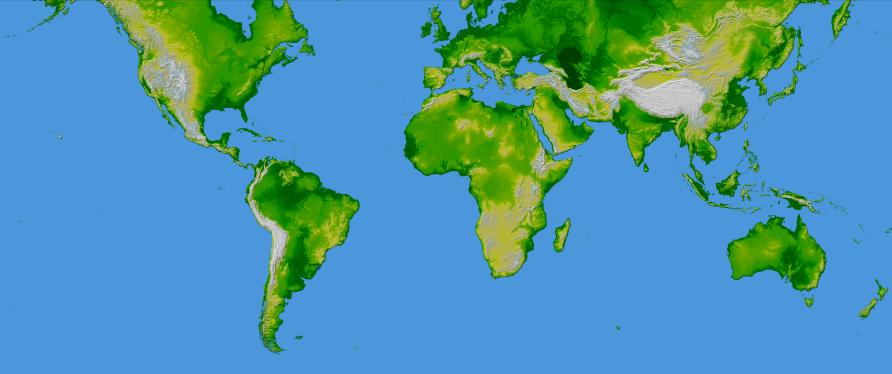
These are our Shuttle Radar Topography Mission (SRTM) Mercator projection maps. These maps are created by coloring the highest peaks white, the seas blue, and all elevations in between varying shades of green and yellow. Note they are not satellite photos, but maps generated from a data set from the SRTM. For more on the Shuttle Radar Topography Mission, Click Here to visit JPL's own fabulous gallery of photos from the SRTM. and see the Jet Propulsion Laboratory's (JPL) description of the mission below from their website.
Chroniclemaster1 has edited in these maps using Google's free Picasa2 photo editing program. Contrast and sharpness have been adjusted from the original photos to maximize visibility and bring out details.
This image shows an SRTM data set for the world in a Mercator projection. It was created from an original map produced from data obtained by NASA's Shuttle Radar Topography Mission (SRTM). Using Google's free Picasa2 program, the color and lighting were enhanced and then sharpened to obtain the image above. Using a free trial version of Adobe Photoshop, the image was then sliced into pieces and assembled in Yahoo! PageBuilder. Black and white images of each continent with the name in white were created to provide the mouseover image. The original map is available at the NASA link above.
For an introduction about map projections Click Here.
Editor: chroniclemaster1 First Date Posted: 2005/07/07
Proofreader: chroniclemaster1 Last Date Revised: 2006/01/05
Researcher(s): chroniclemaster1
Subjects: Administrative, Maps