Africa - with Rivers and Lakes Included
 Click here to return to the main Africa map. |
| Back to Earthchronicle.com Atlas Home | Back to Earthchronicle.com Homepage | Chronicle Subjects (Alphabetical or ECAN Codes) | I Have Something to Add! | Image Index |
| Have a Question? Ask Us! Have an update, suggestion, or found an error? Email Us! | ||||
Africa - with Rivers and Lakes Included |
|
|
|
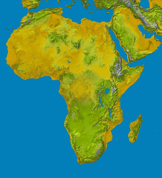
NASA/JPL/NIMA. “AfricaSRTM-Water-picasa.jpg” Online Image. Shuttle Radar Topography Mission. 16 May 2005 73kb. 552×604px. <http://photojournal.jpl.nasa.gov/jpegMod/PIA04965_modest.jpg> Africa - with Rivers and Lakes IncludedThis image shows an SRTM data set for the continent of Africa. It includes water, ie lakes, rivers, etc. added in. It was created from an original map produced from data obtained by NASA's Shuttle Radar Topography Mission (SRTM). Using Google's free Picasa2 program, the color and lighting were enhanced and then sharpened to obtain the image above. The original image can be viewed at the NASA link above. (Here's an important note for this image if you have looked at other SRTM data maps. The green and yellow colors have obviously been reversed from the Africa map with normal SRTM colors, probably by mistake.) |
||||
| Author: | chroniclemaster1 | Date Received: | 2006/01/02 |
|---|---|---|---|
| Editor: | chroniclemaster1 | First Date Posted: | 2006/01/02 |
| Proofreader: | chroniclemaster1 | Last Date Revised: | 2006/01/02 |
| Researcher(s): | chroniclemaster1 | ||
| Subjects: | Maps | ||
| Back to Earthchronicle.com Atlas Home | Back to Earthchronicle.com Homepage | Chronicle Subjects (Alphabetical or ECAN Codes) | I Have Something to Add! | Image Index |
| Have a Question? Ask Us! Have an update, suggestion, or found an error? Email Us! | ||||