The Dacians - People of Ancient Times
Menu:
THE AREA OF THE ORASTIE MOUNTAINS
1. The center of Dacia
- The Area of the Orastie Mountains reprresented, in the period between 1st century BC and 1st century AD, the political, economical, military and spiritual center of Dacia, witnessing the most advanced and flourishing form of the Dacian civilization.
- This region was favored because of the presence here of the rich deposits of iron, but also of the Dacians' sacred mountain, Cogaionon (identified, today, with the mountain of Sarmizegetusa).
2. The natural settings
- The Area of the Orastie Mountains is boordered by the rivers Strei, Mures and Sebes.
- The geographical name of the mountains is that of Sureanu Mountains; these mountains have several peaks reaching 1900-2000 m in altitude. (The name of Orastie Mountains is used by historians and archeologists).
- Besides iron, the mountains could not ssupply the inhabitants the necessary food and the stone for the constructions (because the stone there was too brittle). That's why the food was provided by the fertile valley of the Mures river, and the block of stone were brought from distances of several tens of kilometers (the limestone from near the modern town of Calan, and the andesite, from near Simeria).
3. The Dacian relics
- In this region, the Dacians built fortrresses (Costesti - Cetatuie, Blidaru, Piatra Rosie, Sarmizegetusa), as well as civil settlements, densely populated in ancient times (the civil settlement of Fetele Albe and those near the citadels of Costesti and Sarmizegetusa).
- Besides these important relics, in the whole area, have been discovered many watch towers, isolated dwellings, workshops, etc.
COSTESTI
4. Placement
- The citadel stands on the hill of Cetattuie, at the point in which the valley of river Gradiste (Oras) suddenly becomes narrow.
- From the peak of the hill, which is 5611 m high, one can easily watch a large region, stretching up to the river Mures.
5. Defense system
- In the beginnings, the citadel was defeended by an earthen wave, with a length of 340 m.
- Then, were built 4 towers, with an averrage size of 12 X 12 m, and with their walls built in the technique called murus dacicus. Three of these towers were united by a wall (also murus dacicus). This wall is strengthened by 7 buttresses, which also had the role of sustaining a fighting platform.
- Besides these towers, we can find threee more, which were built north and east of the citadel, outside the earthen wave.
- The defense was also provided by a doubble palisade of wood, inside the citadel.
6. Murus dacicus
- Murus dacicus is the Latin name for thee Dacian technique of building walls.
- The limestone blocks were placed one neext to another, perfectly arranged, in two parallel rows. The space between the walls was being filled with small stones and earth, very well compressed.
- Because this filling was causing a presssure against the walls, the Dacians carved channels in the blocks, narrow at the inner end, and larger at the outer end, in which they fixed beams of timber, which, thou, sustained the walls.
- In the same technique, the Dacians raiised the walls of Blidaru, Piatra Rosie and Sarmizegetusa fortresses.
7. The dwelling-towers.
- On the upper plateau, leveled by the Daacians, were built, inside the citadel, two dwelling-towers. As these are the only Dacian dwellings made of stone, we assume that they are the residences of the Dacian kings.
- These buildings had two floors; the firrst floor was made of stone, in the murus dacicus technique, and the second one, of bricks. The access at the upper floor was provided by an interior staircase, and, at the dwelling-tower no.1, have been discovered the traces of an exterior one.
- The roof was made of large tiles.
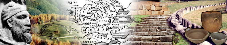
- Next to the dwelling-towers no.2 we cann observe a monumental stairway, made of limestone blocks.
8. The sanctuaries
- The archeologists have found 4 sanctuarries, consisting of alignments of stone plinths. Only one of them was situated inside the fortress, while the other 3 outside.
- The largest sanctuary lies north of thee citadel, being made of 4 lines with 15 plinths.
- The limestone bases had the role of suppporting timber columns. We don't know more about the architecture of these sanctuaries.
9. Other Dacian relics
- The Dacians dig, inside the fortress, ttwo cisterns, which had the role of supplying the citadel with water.
- On the peak of the hill, have been disccovered four blocks that supported the logs of a watchtower.
- A large civil settlement existed at thee base of the hill.
BLIDARU
10. Citadel with military purpose
- The citadel was situated on the Blidaruu Hill (with an altitude of 705 m) and is the most imposing Dacian fortress, having a purely military purpose. For raising the citadel, the Dacians had to excavate the top of the hill and to level the surface.
11. The stages of construction
- The citadel was built in two stages.
- In the second stage was built a new forrt, which included also the isolated tower. The wall between the two forts was partially demolished. A new gate existed in the eastern wall.
- On the northern and western sides of thhe fortress, inner walls were also built, but in a different technique (mica schist plates which alternated with limestone blocks). They formed rooms for provisions, but also sustained a war platform.
- This stage dates from the period of thee reign of Decebalus.
12. Other relics
- Inside the citadel have been discovereed a dwelling-tower and the traces of wooden barracks for the troops.
- An interesting construction can be obseerved outside the fortress - the cistern which supplied the water, which was indispensable, especially during a siege. The cistern had a size of 8 x 6 m, a height of 4 m, and the inner walls were waterproof. The cistern was probably built by a Roman engineer.
THE FORTIFICATIONS OF PIATRA ROSIE AND CIOCLOVINA
13. Piatra Rosie
- The citadel was situated on a hill withh an altitude of 831 m, and played, together with the walls at Cioclovina, played the role of defending the capital of the Dacian state on the direction of the valley of river Strei.
- The fortress had a rectangular shape, 1102 x 45 m in size, and has 4 towers placed at its corners, and one on the eastern side.
- Inside the fortress, there existed a laarge wooden building, its base of stones being perfectly preserved.
- With the purpose of gathering the waterr, at the north-western corner of the citadel the Dacians dig a cavity.
- On the eastern versant of the hill, theere existed a second fort, united with the first, with its walls made of stone and of palisade, having inside a paved road. At the gate of the first fort we can see a limestone stairway, 2.5 m wide, with a balustrade on its sides.
- Around the citadel, the Dacians raised several watch towers.
- The traces of two round sanctuaries (siimilar to those at Costesti) have been discovered near the fortress.
14. The system of walls from Cioclovina
- One of the strongest Dacian fortificatiions is that near the village of Cioclovina, consisting of a system of walls.
- The main wall has a length of 2.5 km annd includes several bulwarks. Next to this wall, there are a number of 33 perpendicular walls (with lengths varying from 50 to 100 m). All the walls are 8-14 m wide.
FETELE ALBE
15. The large civil settlement
- In ancient times, at Fetele Albe there existed a large civil settlement, with various buildings, raised on the 30 artificial terraces (the Dacians executed massive excavations in the slopes of the mountain).
- Of the Dacian building, made of wood annd clay, only the base of stone remained. The dwellings were had, most often, a polygonal shape, with two concentric rooms. The outer room served for storage and the inner one for living. Workshops, a large granary (with large vessels for provisions) have also been discovered.
- Some of the terraces were sustained witth walls, built in the common technique.
- The Dacians collected water sources, annd transported the water in ditches or pipes (made terra cotta and of clay).
- The archeologists discovered two circullar sanctuaries, consisting of a circle of limestone pillars.
- The settlement began its existence in tthe 1st century BC and it was burned down in both wars with the Romans (the second wars marks the its end, in fact, the end of all the citadels and settlements around the capital of the Dacian state).
UNRESEARCHED SITES
16. The citadel of the Peak of Hulpe and the settlement of Ceata
- On the Peak of Hulpe (902 m), the numerrous limestone blocks fallen on the slopes, testify the existence of a strong fortress that secured the access to Sarmizegetusa through the valley of river Sibisel.
- At Fata Cetei (near Ceata Peak of 1237 m) there are about 40-50 anthropogenic terraces, some of them of 100-150 m long, all inhabited in ancient times. The settlement of Ceata seems to be the second largest Dacian settlement, the first being that of Sarmizegetusa.
- The two locations haven't yet been inveestigated by archeologists.
SARMIZEGETUSA
17. The history of the citadel
- In the beginnings, Sarmizegetusa was veery important because of the presence here of the sacred mountain, Cogaionon, and of the residence of the high priest. The great king Burebista established his capital at Costesti, near his advisor, the high priest Deceneu. After the death of Burebista, Deceneu became king and moved the capital to Sarmizegetusa, (and it remained so until the roman conquest).
- The Romans, after the conquest, didn'tt allow the Dacians to settle again in Sarmizegetusa or anywhere else in the Area of the Orastie Mountains.
18. The civil quarters
- All the buildings on the Gradistea Hilll were raised on artificial terraces. The amount of work involved in the realization of these terraces is quite impressive.
- The civil settlement of Sarmizegetusa wwas a compact one, and was the largest Dacian settlement, covering the entire hill of Gradistea.
- Although most of the terraces haven't bbeen investigated yet, a lot of dwellings, workshops, granaries (which stored grains, as well as vessels and tools), installations for collecting and transporting of potable water.
- There existed many types of dwellings: with a single room, with two or more rooms; rectangular, circular or polygonal, sometimes with two floors. From these houses, all that is left are the stone base, and a few remains of the walls, carbonized pillars, fireplaces.
- There also existed various kinds of worrkshops: workshops for processing the iron ore, for obtaining bronze; forges; carpenters' and potter' places. We also believe that there was even a workshop for producing glass.
- The installations, mentioned above, broought water to the dwellings and to the workshops.
19. The fortress
- The fortress of Sarmizegetusa was builtt around the peak of 1000 m.
- The walls, that delimited a rectangularr perimeter, were raised in the common technique, murus dacicus. There existed, on the western side, some perpendicular walls, forming storage rooms and wars platforms, like those at Costesti or Blidaru.
- After they conquered the citadel, the RRomans rebuilt and enlarged it. We suppose that there existed bulwarks, but they were eliminated by the Romans. We can observe, in the rebuilt walls, andesite columns from the sanctuaries, slabs from the paved road, segments of channels, pieces of vault, etc.
- After they systematically destroyed alll the Dacian buildings, they left a detachment of a legion to stay in the fortress. For this detachment, barracks and baths were built.
20. The sacred area
- At Sarmizegetusa have been discovered aa number of 11 sanctuaries, of two types: rectangular (9) and circular (2).
- The terrace, on which most the sanctuarries stand, is the largest terrace made by the Dacians. For preventing its collapse, a system of draining ditches was realized.
- The constructions of limestone date frrom the period of the reign of Burebista and his successors, and those of andesite from the time of the reign of Decebalus.
- At the limestone sanctuaries, the stonee plinths sustained wooden columns, while at the andesite ones, the columns were also made of andesite. Usually, the andesite sanctuaries, replaced others made of limestone.
- The archeological discoveries testify tthe existence of roofs.
- The oldest sanctuary, the large sanctuaary of limestone, was built during the reign of Burebista. It consisted of 4 rows of 15 plinths each. The terrace was sustained here with a wall, and the access to the sanctuary was provided a stairway.
- An interesting sanctuary is the large ccircular sanctuary: its edge consists of two rows of andesite blocks; its interior is made of a circle of wooden pillars, and at its center, another one. The construction probably had three rooms, the wooden pillars being united with clay, thus forming the walls. The sanctuary had a cone shaped roof which was supported outer pillars and by the walls.
- The rectangular andesite sanctuary had 18 columns, but they were destroyed by the Romans. The sanctuary was surrounded by a balustrade.
- On an upper terrace, exists a large saanctuary; its construction began during the reign of Decebalus and was never ended.
- In the sacred area we can also see an aandesite disc, with a diameter of 7 m, representing a sun (There is a central disc and several lateral plates, which form the rays). The monument served as an astronomical instrument - a gnomon or even an astrolabe - (on the disc have also been discovered some marble pieces, with the shape of letter "T", which were used in astronomical calculations).
- From the monument starts a line of stonnes, which perfectly indicates the south-north direction (on which the shades are projected at midday.)
- Probably, "The Andesite Sun", was also used as an altar for sacrifices.