|
Start: Berkeley High School |
0.2 |
| 1: Turn LEFT (West) onto
University Ave |
1.7 |
|


|
| 2: Take Ramp (RIGHT) onto
I-580 [I-80] towards I-80 / I-580 / Richmond / Sacramento |
1.3 |
| 3: Keep LEFT onto I-80 [Eastshore
Fwy] towards I-80 / Vallejo / Sacramento |
17.1 |
|
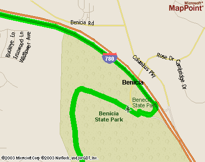
| 4: Turn RIGHT onto Ramp
towards I-780 / Benicia / Martinez |
0.1 |
| 5: Take Ramp (RIGHT) onto
I-780 |
2.4 |
|
| 6: Turn RIGHT onto Ramp
towards Columbus Parkway |
0.1 |
| 7: Turn LEFT (South) onto
Local road(s) |
1.0 |
| 8: Bear LEFT (East) onto Local
road(s) |
0.2 |
| End:
Benicia State Park |
|
|
|
|
 Benicia State Park web
site
Benicia State Park web
site