|
Thrapston's dismantled railways and how to walk them
Thrapston had two railway stations. Bridge Street station was on the London & North Western Railway line. Midland Road station was on the Midland Railway line. This station was used as an office but was damaged by a fire and then abandoned. It has now been completely demolished.Perhaps their most important passenger destinations were to larger towns about ten miles away, the first up the Nene valley to Wellingborough and the second to Kettering. Bridge Street station was closed to passengers on the fourth of May 1964. Goods traffic was phased out between then and 1972. The last train from Kettering to Thrapston was on the thirteenth of June 1959. Dr Beeching's cuts in rail services in 1965 were apparently not to blame for the demise of Thrapston's railways. There is an excellent web page with map about Thrapston's railways, part of Thrapston Online. |
|
The LNWR route to the north of Thrapston Part of the LNWR route is still walkable near the largest of the 'gravel pits' close to Thrapston. In 1972 one of the last acts of the former Parish Council was to purchase the LNWR track bed from British Railways for 200 pounds. Part of the route was officially made a footpath and is designated NX2. It is called 'Thrapston Town Walk'. The line enters a cutting and then stops at the track leading to the Titchmarsh nature reserve from the main road. You can still follow where the line used to be by following the line of the hedges across fields. On the other side of the track that leads to Titchmarsh marina is an embankment that is so overgrown it is often impassable. It terminates in a big ploughed field. However, it is still possible to see the line of the track bed at least part of the way across the field by the lighter coloured stones. At the far corner of the field are the remnants of a bridge next to the road and Thorpe Waterville. On the other side of the main road the first house is the old station. It has a sign that states this. The gardens of this and its neighbours include the track bed, but after this is a good clear section of line. It goes under a road and then becomes a cutting. Here trees have been planted recently and it becomes more manicured till you reach what appear to be paddocks and gardens, with ponds and trees. I crossed a paddock and then I was in the village of Wigsthorpe. The line is not obvious from here, much rubble has been dumped. The Nene Valley Way passes just to the west of Wigsthorpe. an account of my 2004 walk along this route A preserved steam railway runs seven and a half miles from Wansford Station to Peterborough. A museum and exhibition engine shed, plus a shop and café, are at Wansford. Contact the Nene Valley Railway (telephone (01780) 784444) for timetable and fares. The stations were Thorpe, Barnwell, Oundle, Elton, Wansford, (some sources: Castor), Overton and Peterborough. The former station buildings at Thorpe Waterville, Barnwell and Oundle are now private houses. |
|
The Midland Railway route to the west of Thrapston Trains leaving the Midland Road station towards Kettering crossed over the road by a bridge. They went over the river by a viaduct, and then crossed over the LNWR line over another bridge. It is still possible to walk over the viaduct and the second bridge, although in recent years the bridge crossing Midland Road has been removed. Most of the route between Thrapston and Kettering now lies under the A14. A new bridge was made for the road, parallel to the viaduct. A small section of the route can be seen at Cranford. The former station buildings at Cranford and Twywell are private houses. Thrapston Midland Road station is now a business. Just to the west of Cranford is a footpath going south from the road. It turns left and here you can see part of the track. Running west is a short stretch full of lime trees and cuckoo pint. There are also a few Scots pines.  Running east is a short stretch that runs along by back gardens and ends in a fence.   It is interesting to follow the footpath as it continues south (after having gone east a short distance, parallel to the track). It goes under the A14 in a tunnel and comes out near an old quarry.  Just as you are come out of Cranford is a bridge over the old railway and you can see it going both ways in a cutting. Ironstone and limestone were quarried in the area and the Kettering to Cambridge line carried much of this. There are many disused quarries in the area, the best place to see them is at Twywell Hills and Dales, which is off the A14, about halfway between Thrapston and Kettering. There were smelters at Islip Sidings, and an iron foundry (Smith & Grace Ltd) in Midland Road opposite gas works. Near the Midland Road station was a large quarry, now bisected by the A14. The part of it to the south of the A14 seems to be almost totally overgrown now with hawthorn. To the north, nearer the town, it is still worth exploring. A large building used for grading the ore before it went onto train wagons can be seen near the station. |
|
The LNWR route to the south of Thrapston From a point to the west of the river and just south of the A14 (on the Nene Way), you can walk along part of the old LNWR route to the river lock between Woodford and Denford. 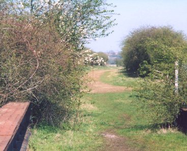 It is neither overgrown nor does it flood. The Nene Way will also take you to this lock, but via Denford, and by a route that is flooded for much of the year. Near the lock there is a rebuilt rail bridge that crosses the river.  The route continues on the other side of the river and there is another rebuilt rail bridge, close to a line of Lombardy Poplars planted along the river bank.  The route continues and comes close to Woodford Mill and its marina. There is another rebuilt rail bridge here.  After Woodford Mill, the route is not so easy to see. It continues along by a lake and then through trees until it is crossed by a track. Cars can come up and down this track and there is a car park near here. On the other side of this track, the route can be clearly seen, and it continues to Stanwick Lakes. There is a bridge over a branch of the river, and then an area recently landscaped. Another bridge takes you to a very open and windswept landscape till you get to a road. This road is the road that runs along by the A6. The route crosses the road and then goes under the A6. After another bridge is a long straight stretch before more lakes. It is not so easy to find the way but you will come out near a sewage works. The works are on top of the route, as is the road that leads to it, but you can follow the Nene Way along by the river till you get to Ditchford Road. On the other side of the road you can easily find and follow the route but then after a short distance it stops abruptly. A line of electricity pylons is parallel to where the route was. It stretches up to the main line between Wellingborough and London.  I have now investigated this area an account of my 2005 walk along this route. an account of my 2004 walk along this route The Nene Way is good if you want to visit many of the villages in the valley, but it is circuitous. The LNWR route is much more direct, and because of the cuttings and embankments it is nowhere steep, unlike the Nene Way. The stations were Ringstead & Addington, Higham Ferrers & Irthlingborough, Ditchford, Wellingborough, Castle Ashby & Earls Barton, Billing and Northampton. Castle Ashby station is now a restaurant. Some sources say that Blisworth was the last station on the line. The Summer Leys nature reserve on the other side of the river from Great Doddington has a path on its north-western edge that was part of the LNWR line. |
|
The Midland Railway route to the south of Thrapston If you walk south along Midland Road you can go under the A14 road bridge and scramble up to the road. Walk along a few yards and you will see a leylandii hedge. If you push through this while simultaneously climbing the low wooden fence, you will find yourself in a cutting. It is full of earth and rubble, but it gets better as you go on. In summer the route is overgrown with nettles and in winter there can be some flooding. If the route is too difficult you can climb up the left hand side and walk along the edge of the field. On the other side of the field is the old quarry, which can be explored if you don't mind pushing your way through hawthorn bushes. The cutting becomes an embankment where it crosses the little valley of a stream, then a cutting again..  Crossing the route is a road bridge. You cannot get under it, but before you get to it there is a gate to a field on the right-hand side. Cross the field to a gate where the road is. On the other side of the road is another gate then more fields. You can go through these fields to get back onto the route, which is now turning south-east. Alternatively, go along the road over the bridge and there is a gate on the right. There is a fenced-off area where the track was but beyond this is a cutting and then an embankment. It is possible to walk along most of it, where this is not possible walk through the fields or along one of the footpaths. There are two footpaths from Denford eastward to the A45 and beyond. The northern one goes over the embankment and the southern goes under through a tunnel. The northern one had bullocks which galloped up to me and were quite intimidating, and the southern one is often flooded and muddy. If only the embankment between the two crossing-points could be cleared, these two problems would be avoided and the walk would be more interesting. The embankment ends at a fence, and then there is a pond just before the A45. On the other side of the A45 the track continues and you can follow it if you don't mind pushing through wild roses and brambles. It becomes a cutting, and once or twice I heard water running down the side. I could not see it because of the brambles, and I have no idea where it runs to. You come out near the water tower on Brooks Road. The route continues on the other side of Brooks Road, but it starts muddy from runoff from the farm buildings next to it. You are likely to be informed by the farmer, as I was, that it is not a right of way. (Apparently she can use it as a dump for her slurry, but we can't use it for walking.) The next part of the cutting is lovely and clear, but then it was flooded. Normally I would walk through the fields, but it was too difficult to get out. You can miss out this section by walking along Brooks Road, east and then south. On the east side of the road Birch Farm blocks the next part of the route, but if you are willing to cross the fields eastwards between Birch Farm and Park Farm you will come to a lovely straight clear track. This goes all the way to the Raunds Station buildings, which are used in some kind of car business. A footpath crosses this section at right-angles, but you have to walk across a ploughed field. I don't like walking across ploughed fields, with the clay adhering to my boots, but I do like walking along a nice track. If farmers have a problem with this, then I don't care. I don't know much about trespass or rights of way. So often part of a railway track is clearly the best way for walkers to get from A to B. Yet the bureaucrats who make the decisions about footpaths send us anywhere but the best way, across ploughed fields or flooded meadows. There may be a reason for this; it could be that footpaths established perhaps hundreds of years ago have a sanctity that more recently established routes do not. However, it has always seemed crazy to me that the route all the way along the Nene Valley from Peterborough to Northampton could not have had some value. When you think of all the man-hours spent levelling the route, with all its cuttings and embankments. All the effort in negotiating land purchases. At least the Northampton to Market Harborough track is now an official footpath. From Raunds station the track seems impassable, judging from arial photographs (from multimap). Part of the track looks as if it has been ploughed up. The next station was Kimbolton then Grafham. Leaving Northamptonshire, it went to Huntingdon, ending in Cambridge. |
| name of station | opened | company | route |
|---|---|---|---|
| Bridge Street | 1845 | London North Western Railway | Peterborough to Northampton |
| Midland Road | 1866 | Midland Railway | Kettering to Cambridge |