
Benton County, TN Online Website

New Benton County, TN News Website


SUSAN CORBIN'S FIRE & FLOWER WEBSITE
Listings may be incomplete, we are still under construction. If you have any information to add, please let us know.
Benton County, TN Aerial Map
 GREAT LODGING AND CAMPING FOR GENEALOGY BUFFS & Bird Watchers - CLICK HERE
IRISH CEMETERY *not recommended for visiting, very treacherous*
Listing of DENNIS RUSHING CEMETERY
The OLD LIBERTY CEMETERY is located in a most remote spot, on the Tennessee National Wildlife Refuge, but extremely difficult to find and nearly impossible to roam through since at least 1 of 3 tornadoes that set down during Memorial Day Weekend 2000 hit this area hard. It took us about 7 miles of hiking to find it, and then it was pure LUCK!
Listing of Graves at RUSHING CREEK CEMETERY, Big Sandy, TN.
Will be adding individual marker stones as soon as possible.(UPDATED MARCH 23, 2002) w/links to tombstone pictures.
Photo of RUSHING CREEK CEMETERY
RAMBLE CEMETERY Listing
Photos of RAMBLE CEMETERY
List of Graves at CAMDEN CITY CEMETERY
Will be adding photos of stones soon.
Photo of LINDSEY CEMETERY, Big Sandy, TN.
LINDSEY CEMETERY Listing
FLATWOODS CEMETERY Listing
 Link to BENTON COUNTY HISTORICAL SIGHTS.
Historical Page 2
 Link to SOME BENTON COUNTY BEAUTY.
Old Dogtrot on Reynoldsburg Rd. - this place would of sat just about where the Herrins were located,. It's gone now, the folks having put in a huge pond, tore the dogtrot down.
Christopher Manor is over 100 years old and sits directly across from the National Wildlife Refuge which used to be the Old 23rd District. Although it sits in Henry County, it's considered Benton County because of the lack of access from Henry County. It's the northern most tip -the point of the peninsula. W.C. McDaniel owns Christopher Manor and it's historic background.
Prater Road would fall somewhere in the Rushings' land settlement area. It looks pretty much as I would of assumed it did back then. This is also called the Bakers' Chapel Community - all part of Big Sandy.
Rushings' Creek - this is where it meets up with 69A here and it's breathtaking in the fall. This shot would be looking towards 641 on the map. This area of the creek would of sat on the outside perimeter of what they called Pleasant Valley. The bridge has been named the Dennis Rushing Bridge (you can't see it, I'm standing on it to take the shot!).
The Crooked Creek Road leads now only to the Crooked Creek Cemetery since eveyrthing was moved to provide for the flooding of the TN River to turn it into Kentucky Lake. But the church that I had on the other page, would of sat back in here. As well as a school.
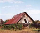
The W.C. Rushing homestead - I do believe if I remember correctly that this is the Willis Crawford Rushing place. This shot was taken about 6 or 7 years ago and it's long since fallen down. It was a grand two-story with that gingerbread trim. Although it resembles a "salt box" look, it was not - the roof was flat and straight. I think it must of been one of the first two-story houses - at least in this area! Willis Crawford was the son of one of the first settlers in the Rushing Clan. And it sat directly across from the "Yard Sale" or Lockhart house. Now the highway 641 runs between both properties and the Lockhart house was torn down last summer. This house - the W.C. house, sits way back in a grove of trees and is impossible to view from the road.
The Springville Post Office - isn't really in Benton County, but in Henry County - but close. It was an important part of our history here. It's long gone and falling apart fast, too.The Train Tressel - this is from the old abandoned train tracks and it's over Crooked Creek in this shot.
 The Town of Big Sandy - this is an aerial summer shot that I did and shows quite a bit. At the top, that's the Big Sandy River butting up close to the town. It actually sits HIGHER than the town. But remember, back before 1940's, it wasn't this large - not until they flooded the TN River. If you look closely, you'll see the "earthen dam" or dyke that "snakes" around the town. At one time, this was also the train tracks, and probably served two purposes. The town forefathers were warned that the town could easily flood and should move the town. They rejected the idea and built the dam instead. On the far right you'll see a narrow bridge and a larger bridge. The narrow one is the "walking" bridge across the spillway and the larger one, that's the road (the ONLY road from town) that crosses here and leads to the Danville/Lick Creek road split. Still a very small town, quaint. No Wal-Marts, or big stores here - no McDonalds, no fast food. Still the old fashioned restaurants and NO department stores. In fact, I think there are only 1 or maybe 2 2-story buildings.
Sue Corbin is putting alot of hard work into this effort for others to enjoy. Thank you for visiting!