
Arastradero Preserve
Part 1
![]()
Arastradero Preserve
Part 2
![]()
Arastradero Preserve
Part 3
![]()
Arastradero Preserve Virtual Reality Tour
![]()
Arastradero Preserve Stewardship Project

Directions
Park
Info
Map
![]()
SF Bay
Rec. &
Travel
Part 1 - Info and the Corte Madera Trail
![]()
|
Bay Area Parks |
Bay Area Hiking |
County Parks |
Feedback |
Introduction
Palo Alto's Arastradero Preserve encompasses over 600 acres in the foothills of the Santa Cruz Mountains above Palo Alto. The preserve ranges in elevation from 275 to 775 feet and includes more than 6 miles of trails. It is located on Arastradero Road between Alpine Road and Page Mill Road. Parking is on the north side of Arastradero Road, while most of the park is on the south side of the road. The preserve's land was purchased by the City of Palo Alto in 1975 to protect it from development. It is a popular place for hiking, mountain biking, and horseback riding. It abounds in wildlife and springtime wildflowers. The trails range from wide gravel roads to narrow single-tracks. The terrain varies from rolling grasslands to shady oak forests. The higher hilltops provide spectacular views of the surrounding area, which includes Felt Lake, Stanford University's open space lands and satellite dishes, Palo Alto, Moffett Field, and the Bay. On clear days, the view stretches from San Francisco to San Jose. Behind the preserve to the west are the forested slopes of the Santa Cruz Mountains.Arastradero Creek
Arastradero Creek is the main creek running through the park. It runs along the east edge of the park below the Palo Alto Hills Golf and Country Club. The creek originates in the hills of Palo Alto's neighboring Foothills Park. It flows into the southeast corner of Arastradero Preserve feeding first into a couple of tiny ponds and then into Arastradero Lake, a beautiful reed-lined pond that is open for fishing. Arastradero Creek drains out of Arastradero Lake and flows out of the preserve. The creek eventually flows into Matadero Creek, which runs through Palo Alto, passes Bol Park, and enters San Francisco Bay at Mayfield Slough in the Palo Alto Baylands Nature Preserve.
Arastradero Preserve Stewardship Project
One factor that makes Arastradero Preserve stand out from other open space parks in the Bay Area is the intense amount of restoration activities going on here. Even though California has a lot of undeveloped open space, these lands do not look the same way they did when the Native Americans were the only people living on them. European settlers brought cattle and weed seeds in their feed. They also planted trees and plants from overseas. The result is that the California "natural" environment is an unnatural mix of foreign invaders and imports. An ambitious goal of the restoration activities in Arastradero Preserve is to eliminate non-native vegetation and restore the natives.Acterra, a Palo Alto-based environmental group, acts as a steward for the preserve through their Arastradero Preserve Stewardship Project (APSP). Their activities include habitat restoration, trail maintenance, storm damage repair, and environmental education. Restoration activities include controlling non-native teasels, planting native grasses, installing bird nest boxes, and removing eucalyptus trees. They have volunteer work days for habitat restoration. See the calendar for work days.
One of the activities of the APSP is to combat the notorious spiny yellow star thistles. These non-native invaders line the narrow trails at ankle and calf level, making for painful walking for hikers in shorts. They also crowd out native plants, which means less food for the animals that depend on them. These thistles are a major pest, and with their 8-foot taproots, they are difficult to get rid of. The APSP is using mowing and weevils to try to control them.
Here are pictures of some restoration projects:
(Click on the thumbnails for a larger picture. Hit the Back button
on your browser to return.)
 |
 |
 |
 |
Maps
Here is the park map and the legend for it. You can pick up a copy of this map at the main parking lot.(Click on the thumbnails for a larger picture. Hit the Back
button on
your browser to return.)


The current preserve map shows only 4 trail names for the park's main
trails, and the small side trails are unnamed. The names on the current
park map will be used on these pages since these are the names on the
trail
signs.
When I visited the park in June, there was a map in the display case, showing the proposed trail system map. It showed proposed names for the park trails. It gave separate and new names to the park's trail segments, renamed some trails, and named many of the currently unnamed trails. Here are pictures of that map, split into 2 parts:
Northeast corner: northern hills, park entrance, Arastradero Lake:

Southwest corner: Sobey Pond, Foothills Park boundary, Meadowlark , Acorn, and Perimeter Trails:

When I went back to the park in July 2001, the map was gone,
but there
was a notice saying that the trail plan had been approved by the city.
Trails will be restored. Some will be re-routed. Expect some changes in
the future.
Guided Photo Tour
Here is a detailed description with mileage readings from my bicycle odometer of a 6-mile route that I took on 6/24/01. The mileage readings are just an indicator of relative distance. You mileage may vary. Most of the pictures below were taken during this trip. Others were taken later in June and July. A few were taken on 5/13/01 and 4/28/98, when the hills were greener. I plan to come back next spring and shoot the hills when the grass is green, and the wildflowers are blooming.(Click on the thumbnails for a larger picture. Hit the Back button on your browser to return.)
 Start at the parking lot on Arastradero
Road. The mileage readings start
here. Pick up a park map. Read the bulletins on volunteer
opportunities
in the park. There are portable restrooms here. Near the restrooms is a
display on native California grasses, some of which are being planted
in
the preserve by volunteers. Be sure you bring lots of water as there is
no drinking water in the park. You can't cross over Arastradero Road
directly
to get to the preserve, as the area across from the parking lot is an
in-holding
of private property. Head down the dirt trail that parallels
Arastradero
Road to the south. It turns and crosses the road.
Start at the parking lot on Arastradero
Road. The mileage readings start
here. Pick up a park map. Read the bulletins on volunteer
opportunities
in the park. There are portable restrooms here. Near the restrooms is a
display on native California grasses, some of which are being planted
in
the preserve by volunteers. Be sure you bring lots of water as there is
no drinking water in the park. You can't cross over Arastradero Road
directly
to get to the preserve, as the area across from the parking lot is an
in-holding
of private property. Head down the dirt trail that parallels
Arastradero
Road to the south. It turns and crosses the road.
 The park's main entrance is here at 0.16
miles. This is the beginning of
one of the main park trails, the Corte Madera Trail. It is a wide
gravel
road at this point.
The park's main entrance is here at 0.16
miles. This is the beginning of
one of the main park trails, the Corte Madera Trail. It is a wide
gravel
road at this point.
 Immediately
after the entrance, Arastradero Creek flows through a pipe
under the trail. It is highly overgrown with creek vegetation and will
probably be dry in the summer.
Immediately
after the entrance, Arastradero Creek flows through a pipe
under the trail. It is highly overgrown with creek vegetation and will
probably be dry in the summer.
 Just beyond the entrance at 0.24 miles,
is
a junction of 2 trails leading
up into the hills to the left. The one on the left will be covered in Part
3. On the right side of the Corte Madera Trail is a stand of coyote
bushes, blocking views of the creek.
Just beyond the entrance at 0.24 miles,
is
a junction of 2 trails leading
up into the hills to the left. The one on the left will be covered in Part
3. On the right side of the Corte Madera Trail is a stand of coyote
bushes, blocking views of the creek.
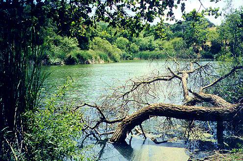
 The creek comes into view at 0.29 miles.
The creek banks are relatively
open here. A fire here destroyed much of the vegetation 15 years ago.
The
creek banks were lined with highly flammable eucalyptus trees. Now,
only
the huge stumps of these trees remain.
The creek comes into view at 0.29 miles.
The creek banks are relatively
open here. A fire here destroyed much of the vegetation 15 years ago.
The
creek banks were lined with highly flammable eucalyptus trees. Now,
only
the huge stumps of these trees remain.
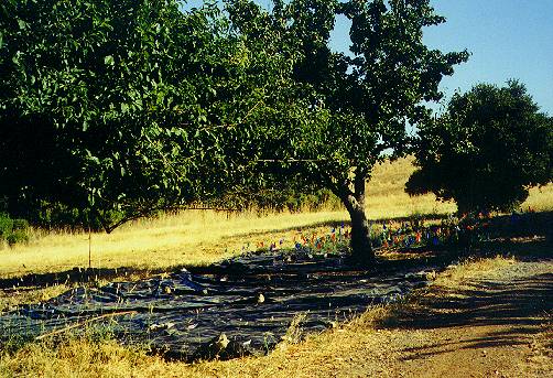
 Restoration work is evident. Small trees
have been planted behind protective
wire meshes.
Restoration work is evident. Small trees
have been planted behind protective
wire meshes.
 At 0.34 miles, the trail comes closer to
the creek. Stream bank erosion
control efforts are evident here. Plant fiber mats are used to
stabilize
the steep banks.
At 0.34 miles, the trail comes closer to
the creek. Stream bank erosion
control efforts are evident here. Plant fiber mats are used to
stabilize
the steep banks.
 At 0.37 miles, the trail crosses the
creek
on a bridge. The vegetation
upstream from the bridge is heavy and blocks views of the creekbed.
At 0.37 miles, the trail crosses the
creek
on a bridge. The vegetation
upstream from the bridge is heavy and blocks views of the creekbed.
 Ahead to the right is a trail junction.
The Meadowlark Trail comes down
from the right and joins the Corte Madera Trail, which turns to the
left
and climbs a hill. The Meadowlark Trail will be taken in Part
2. In the meantime, take the Corte Madera Trail to the left.
Ahead to the right is a trail junction.
The Meadowlark Trail comes down
from the right and joins the Corte Madera Trail, which turns to the
left
and climbs a hill. The Meadowlark Trail will be taken in Part
2. In the meantime, take the Corte Madera Trail to the left.
 The
Corte
Madera Trail runs along the side of a hill. The creek runs below,
marked by the line of trees and bushes.
The
Corte
Madera Trail runs along the side of a hill. The creek runs below,
marked by the line of trees and bushes.
 At 0.58
miles, the trail reaches the creek again.
At 0.58
miles, the trail reaches the creek again.
 On the left, you see the rock-lined
trough
that serves as the spillway
for Arastradero Lake.
On the left, you see the rock-lined
trough
that serves as the spillway
for Arastradero Lake.
 In the
springtime, water will likely be flowing out of the lake and down
the spillway channel.
In the
springtime, water will likely be flowing out of the lake and down
the spillway channel.
 Just ahead, a bridge crosses over the
lake's outlet. Cross over the bridge
to circle around the lake bank.
Just ahead, a bridge crosses over the
lake's outlet. Cross over the bridge
to circle around the lake bank.
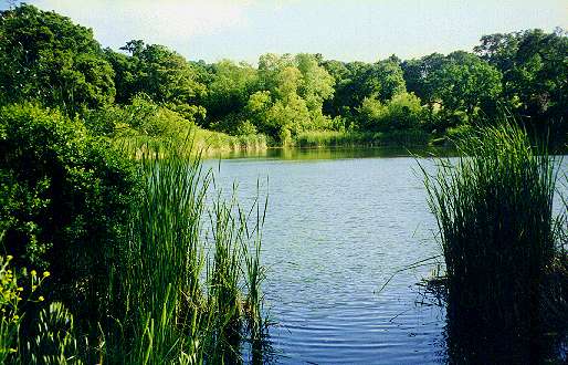
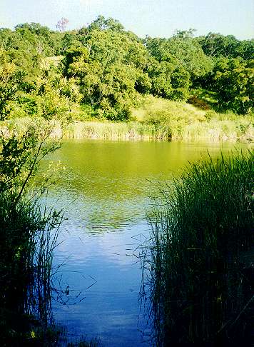
 Trees and reeds block your view of the
lake except for a few clear spots.
One clear spot is near the southeast corner of the lake.
Trees and reeds block your view of the
lake except for a few clear spots.
One clear spot is near the southeast corner of the lake.
Here are some more pictures of Arastradero Lake:
 |
 |
 |
 |
 At 0.68 miles, an old paved road goes
uphill to Paseo Del Roble at the
park boundary. A narrow dirt trail turns right to follow along the lake
bank. Follow this trail through the trees. At 0.71 miles, there is a
small
beach on the side of the lake lined with reeds. There is a trail that
continues
around the lake, but at the time I went, it was closed, so I had to
turn
back.
At 0.68 miles, an old paved road goes
uphill to Paseo Del Roble at the
park boundary. A narrow dirt trail turns right to follow along the lake
bank. Follow this trail through the trees. At 0.71 miles, there is a
small
beach on the side of the lake lined with reeds. There is a trail that
continues
around the lake, but at the time I went, it was closed, so I had to
turn
back.
 Heading back around the lake, cross back
over the bridge and continue to
follow the lake around to the left. At 0.87 miles, you reach a large
trail
junction by a pumping station, the Corte Madera Booster. A wide dirt
service
road goes uphill to the right, crosses the Meadowlark Trail, and
eventually
ends at park gate B on Arastradero Road.
Heading back around the lake, cross back
over the bridge and continue to
follow the lake around to the left. At 0.87 miles, you reach a large
trail
junction by a pumping station, the Corte Madera Booster. A wide dirt
service
road goes uphill to the right, crosses the Meadowlark Trail, and
eventually
ends at park gate B on Arastradero Road.
 The Corte Madera Trail continues to
follow
the lake to the left. A few
gaps in the trees provide views of and sometimes access to the
lakeshore.
Soon the road reaches the end of the lake and continues to follow along
the creek At 0.93, a trail leads to the left to reach the creek and
circle
behind the lake. This trail was closed.
The Corte Madera Trail continues to
follow
the lake to the left. A few
gaps in the trees provide views of and sometimes access to the
lakeshore.
Soon the road reaches the end of the lake and continues to follow along
the creek At 0.93, a trail leads to the left to reach the creek and
circle
behind the lake. This trail was closed.
 The Corte Madera Trail continues to
follow
along the creek. The trail is
wide and shady, with dense growth along the creek. The trees are mostly
oaks, and the underbrush is mostly wild blackberries and poison oak.
Spanish
moss drapes from the oak trees. At 1.08 miles, the trail turns to the
right
and goes uphill. It levels off at around 1.13 miles. From here, the
green
manicured hills of the golf course can be seen above the trees to the
left.
At 1.28 miles on the right is the closed end of the old lower Acorn
Trail.
Dense vegetation blocks views of the creek to the left. The trail again
begins to climb uphill to the right.
The Corte Madera Trail continues to
follow
along the creek. The trail is
wide and shady, with dense growth along the creek. The trees are mostly
oaks, and the underbrush is mostly wild blackberries and poison oak.
Spanish
moss drapes from the oak trees. At 1.08 miles, the trail turns to the
right
and goes uphill. It levels off at around 1.13 miles. From here, the
green
manicured hills of the golf course can be seen above the trees to the
left.
At 1.28 miles on the right is the closed end of the old lower Acorn
Trail.
Dense vegetation blocks views of the creek to the left. The trail again
begins to climb uphill to the right.
 At 1.46 miles, the new lower Acorn Trail
goes uphill to the right as a
narrow single-track.
At 1.46 miles, the new lower Acorn Trail
goes uphill to the right as a
narrow single-track.
 Continuing on the wide gravel road of the
Corte Madera Trail, large expensive
houses come into view on the hilltops to the left. There is a meadow
between
the trail and the trees lining the creek below to the left. At 1.49
miles,
the trail crests, drops a little, rises, then levels off again.
Continuing on the wide gravel road of the
Corte Madera Trail, large expensive
houses come into view on the hilltops to the left. There is a meadow
between
the trail and the trees lining the creek below to the left. At 1.49
miles,
the trail crests, drops a little, rises, then levels off again.
 At 1.63 miles, a new trail runs uphill to
the right. Trees and brush run
closer to the trail as the creek approaches it. At 1.69, the upper
Acorn
Trail climbs steeply up the hill to the right. We'll go up this trail
later.
At 1.63 miles, a new trail runs uphill to
the right. Trees and brush run
closer to the trail as the creek approaches it. At 1.69, the upper
Acorn
Trail climbs steeply up the hill to the right. We'll go up this trail
later.
 On the left, a small pond can be glimpsed
through the bushes to the left.
At 1.72, a small path leads to the pond. This is Sobey Pond. It is a
shallow
pond formed by an earthen dam on Arastradero Creek.
On the left, a small pond can be glimpsed
through the bushes to the left.
At 1.72, a small path leads to the pond. This is Sobey Pond. It is a
shallow
pond formed by an earthen dam on Arastradero Creek.
 Tall reeds grow in the marsh area on the
upstream side of the pond.
Tall reeds grow in the marsh area on the
upstream side of the pond.
 Continuing on the main trail, a sign
ahead
warns that the utility road
ends in 0.6 miles and that there is no access to Foothills Park. The
creek
begins to run through a narrow canyon. The creek above Sobey Pond is
not
much more than a ditch.
Continuing on the main trail, a sign
ahead
warns that the utility road
ends in 0.6 miles and that there is no access to Foothills Park. The
creek
begins to run through a narrow canyon. The creek above Sobey Pond is
not
much more than a ditch.
 The road runs through a shady oak and
laurel forest.
The road runs through a shady oak and
laurel forest.
 The deep, cool shade allows ferns to
grown
on the hillsides. The road begins
to climb uphill.
The deep, cool shade allows ferns to
grown
on the hillsides. The road begins
to climb uphill.
 The creek runs alongside the trail in a
narrow, deep trough at the base
of a steep-sided hill. It is shaded by laurels and buckeyes.
The creek runs alongside the trail in a
narrow, deep trough at the base
of a steep-sided hill. It is shaded by laurels and buckeyes.
 At 2.15 miles is the closed gate and
overgrown road to Foothills Park.
The creek continues on to its origin in the hills of Foothills Park.
At 2.15 miles is the closed gate and
overgrown road to Foothills Park.
The creek continues on to its origin in the hills of Foothills Park.
 The road turns to the right away from the
creek and climbs steeply upward.
The hills become dryer, with coyote bushes growing on the upper slopes.
At 2.34 miles, at the summit of the hill, a paved private road runs off
to the right. A barbed wire fence on the left marks the Foothills Park
boundary.
The road turns to the right away from the
creek and climbs steeply upward.
The hills become dryer, with coyote bushes growing on the upper slopes.
At 2.34 miles, at the summit of the hill, a paved private road runs off
to the right. A barbed wire fence on the left marks the Foothills Park
boundary.
 The road then drops steeply downhill
ahead, but is blocked at the end by
a gate. A sign on the gate, which is the Foothills Park boundary, says
that no entry is allowed ahead. Since it is a dead end, there is no use
continuing on, so head back.
The road then drops steeply downhill
ahead, but is blocked at the end by
a gate. A sign on the gate, which is the Foothills Park boundary, says
that no entry is allowed ahead. Since it is a dead end, there is no use
continuing on, so head back.
For more, go to Part 2 to
continue the
tour along the Acorn and Meadowlark trails. Go to Part
3 for other trails.
Links:
- Virtual Parks Panoramas: Arastradero Preserve
- Bay Area Hiking: Santa Clara County Parks and City Parks
- Chain Reaction Bicycles: Arastradero Preserve
- Parks of Palo Alto
- Palo Alto Open Space Nature Preserves
- Wikipedia:
Arastradero Preserve
- City of Palo Alto
- California Native Plant Society
- Acterra
- Virtual Reality Panorama - Matadero Creek Trail
- Bay Area Biking: Shoreline at Mountain View to Palo Alto Baylands
- Bay Trail: Palo Alto Baylands - Matadero Creek to Byxbee Park
- Bay Area Hiker: Arastradero Preserve
- BayImages.net: Arastradero Preserve
- Trails.com: Arastradero Preserve
- Answers.com: Arastradero Preserve
- birdWalker: Arastradeo Preserve
- Birds at Arastradero Preserve by Garrett Lau
- Walking in Arastradero Preserve
- A Hike to the Headwaters of Arastradero Lake
- SmugMug - John Reed: Arastradero Preserve Birdwallk
- Scott Loftesness: Arastradero Preserve-31 Dec 2002
- POST Purchases Bressler Property to Complete Arastradero Preserve
- MNN: Hard to pronounce, easy to hike Arastradero Preserve
- Trailmonkeys:
Palo Alto, Arastradero Preserve Trails Summary
![]()
Created 7/11/01, links updated 9/27/06 by Ronald Horii