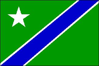
This one arose almost as a doodle, but I so liked the design I submitted it to the New England Journal of Vexillology. Brookline was founded as the village of "Muddy River" back in the XVII Century somewhere. The river still flows, southwest to northeast, emptying into the Charles River in the general vicinity of Fenway Park. Indeed, the "fens" referred to in the name are the wetlands associated with the Muddy River.
In the XIX Century Frederick Law Olmstead designed "The Emerald Necklace", a series of connected parks and boulevards running from Boston Common southwest along the Muddy River to Jamaica Pond and beyond. I tried to capture this image by representing the Muddy as a diagonal blue line running southwest to northeast through the green Emerald Necklace. Since Brookline lies on the west bank of the mighty Muddy, I located it there (and introduced a bit of asymmetry into the flag) by placing a star in the upper hoist. There is a white star in the upper left ("dexter chief") of the Massachusetts coat-of-arms, and this sort of echoes it.
I have never actually suggested this flag to the local power structure, mostly out of shyness, I suppose. Besides, I'm not a Democrat. So it sits in a journal. One of my neighbors was recently elected to Town Meeting; maybe I'll suggest it to him.....