Prudhoe Bay
Alaska
Prudhoe Bay (Deadhorse) Alaska is home to the largest
oil field in North America. It is located in Alaska between the coast of the Beaufort Sea and the North Slope of the Brooks Range Mountains. It is about 1200 mi. south
of the North Pole and 250 mi. north of the Artic Circle.
Summer storm near Kapurak
End of last day, sun will be gone for a couple months!
The Alpine field and facility, about 100 miles West of Prudhoe Bay. Accessable by air only, except during Winter when an ice road is built for re-supply.
Artic Drilling Rig
Artic drilling rigs differ from their southern
counterparts in that they generally are more self contained. As is evidant by the picture, the rigs are inclosed
to protect it and the workers from the Arctic winters. Many of the rigs
can be transported from drill site to drill site without any disassembly.
Most rigs have a camp house that will move with the rig to provide
room and board for the workers.
Wildlife in the area: Artic Fox, Artic Ground
Squirrels, Brown Bears (Grizzly), Polar Bears, Musk Ox, Artic Hares,
Caribou (Approximately 25,000)and over 200 different bird and
waterfowl species including geese, swans, seagulls and eagles .
During the Winter months only the artic fox, ravens,and the
occasional polar bear are to be seen.
Who says Caribou are frightened by the Pipeline?
Red Fox
Small herd of Musk Ox south of Prudhoe.
Mothers day out, bear style!
Brown bear (Toby) learned to open doors! Room service Prudhoe style!
Another one of Toby, he wants to know if W.T. can come out and play!
Mother bear and her new cubs.
Cub climbs to avoid mosquitoes.
Thats the third floor roof, too!
Polar bears feasting on a whale carcass.
Polar Bear near East Dock.
Ice Road To Rig
Ice roads are built during the winter months to
reduce the damage to the enviorment for access to remote drill sites.
conditions need to be twenty below zero or less for construction thus
limiting explority drilling to the winter months in most cases.
Another Ice road picture. This one is 15 miles off shore in Artic Ocean!
A friend took this picture, doesn't that look slick!
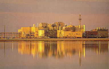
Lisburne Plant
One of many facilities built to handle the oil, natural gas and
other products before being sent down the pipeline.
CPF-1/KCC/KOC (Central Processing Facility, Kuparuk Construction Camp, and Kuparuk Operations Center, all operated by Phillips/Conoco in Kuparuk
View of facility
Home away from home for me.
Prudhoe Bay area as seen from plane.
Alaska Airlines plane at Dead Horse airport.
Prudhoe Bay General Store and Post Office. ("The Mall" to locals)
Prudhoe Bay Beach Club
near West Dock
Try as I might, I haven't yet found out where this
place is, much less how to join. But I haven't given up!
Click below for more pictures from Prudhoe Bay
Schlumberger Stuff.
Whats the weather in Prudhoe like right now? Just click on:
Weather in Prudhoe
Some Neat Weather Facts about Prudhoe Bay
Longest Day:
63 days, 23 hours, 40 min.
Offical sunrise: 12:09 AM - on 20th of May
Offical sunset:11:18 PM - on 22nd of July
Shortest Day:
1 hour, 3 min.
Offical sunrise: 11:42AM - 24th of November
Offical sunset: 12:27PM - 24th of November
Longest Night:
54 days, 22 hours, 51 min..
Offical sunset: 12:27PM - 24th of November
Offical sunrise: 11:18AM - 18th of January
Shortest Night:
26 min.
Offical sunset: 11:43PM - 19th of May
Offical sunrise: 12:09AM - 20th of May
Highest Recorded Temperature
83 degrees F. on 21st of June, 1991
Lowest Recorded Temperature
Minus 62 degrees F. on 27th of January, 1989
Highest Wind Speed Recorded
95 knots (109 mph) on 25th of February, 1989
Offical Lowest Wind Chill Factor
28th of January,1989 - Temp of minus 54 degrees F and Wind speed of 31 knots (36 mph) - Gave a chill factor of minus 135 degrees F.
To My Home Page
To My Golf Page
Sign My New Guestbook
View Guestbook

Last updated 12-12-03