

'From one comes two,
from two comes three
and from three the whole world.'
Lao-tzu (b. 604 BC)
from two comes three
and from three the whole world.'
Lao-tzu (b. 604 BC)
|
|
|
|
|
'From one comes two,
from two comes three and from three the whole world.' Lao-tzu (b. 604 BC) |
The second PSA network Bell discovered radiated from Crookston
Castle, which is situated inside the ramparts of an earlier ringwork.
'Mapwork showed that Crookston Castle is sandwiched in direct alignment between Walls Hill and the Necropolis. But the Necropolis cannot be seen from Crookston, so where was this PSA first surveyed from? To answer this question I first went out to Walls Hill and made a few calculations, then next I turned my attentions to the great hilltop cemetery of the Necropolis - I went in and out that place so often at weekends, the gateman must have thought I was a vampire.
It soon became apparent that there was more to Glasgow's Secret Geometry than I had ever imagined. Some PSAs appeared to converge on the Necropolis; others seemed to have been surveyed from the Necropolis to radiate outwards. The Duncolm/Tinto and Seedhill Craigs/ Provan Hall lines passed straight through. Some of my PSAs had only three sites on the line, but I included them in my maps if any of the three sites was an intersection on another alignment.'
The Necropolis is not far from Glasgow Cathedral, which is marked '1' on the inset map on the top left hand side. No. 2 is the John Knox statue; you can see Tinto Hill from there on a clear day. No. 3 is Barrack Street, about 400m away. A heavy deposit of oyster shells was found there in 1982, suggesting that the area was inhabited in mesolithic times.
'I had set out to find one sightline centre in Glasgow, but in fact I had found three. And the way my PSAs were heading, it looked as if there could be a fourth originating at Carmyle. This one was difficult to understand. Camphill, Crookston and the Necropolis are all on high ground - the fords at Carmyle are on low ground. The two fords are over 300m apart, so the sightline centre must either have been on the banks of the Clyde between the fords, or some site now covered by the power station on the south side of the river near the weir.'
Prehistoric Site Alignments radiating from the fords at Carmyle.
'For a while I wondered if the ridge near the trig point at Cathkin Braes was yet another sightline centre, but the PSAs I found there seemed to be aimed at sightline centres rather than at skyline markers. This made me think that the Braes PSAs were for some reason a later addition to a network already in existence.' (Bell, Glasgow's Secret Geometry, 1993)
The 13th green at Cathkin Braes Golf Course, with ramparts of the ringwork clearly visible.
One of the Camphill PSAs led to the ringwork on the 13th green at Cathkin Braes. Bell's archaeology friends were unimpressed - why had he included a Medieval ringwork on an alleged Prehistoric Site Alignment? Years later, in 1997, when the Association of Certified Field Archaeologists were doing an archaeological survey of Cathkin Braes Country Park, an aerial photograph of the ringwork showed an additional smaller enclosure joining onto the north-east side of the ringwork. ('This is almost certainly a prehistoric burial' ... p16 Glasgow Archaeological Bulletin, No. 36)
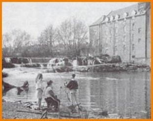
These young anglers are fishing on the site of the earliest
settlement in Paisley,just opposite the Watermill Hotel.
'One alignment I traced in Paisley led to the Watermill Hotel, some 200m south of Paisley Abbey. I was disappointed the line didn't go to the Abbey, which I thought was the oldest site in Paisley; but when I looked into the history of the town, I found to my amazement that the river bank at Seedhill Craigs opposite the Watermill was the site of St. Mirin's original settlement, destined to be abandoned for the Abbey site when the community grew too large for it. Seedhill Craigs is where the White Cart Water becomes tidal and the site is believed to have been occupied in prehistoric times, long before St. Mirin's arrival.' (see M. McCarthy, 1969. A Social Geography of Paisley.)
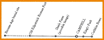
The most important site on the PSA above is the Roman Fort at Old Kilpatrick.
Once the terminal at the western end of the Antonine Wall, the fort is now buried
under the houses of Gavinburn Gardens, near the Forth and Clyde Canal. There
is nothing to see there, but I liked the site, the view down the Clyde, and
in fact the whole area. Was it possible that a prehistoric site lay underneath?
'Nonsense,' said the Romanist scholar I asked about this.
'The Romans chose sites to suit their defensive technique, they did not adapt
their technique to suit available sites.'
I was agreeably surprised to find out later on, that Bronze Age cists (stone
coffins) had been discovered inside the fort in 1923 and 1924 (See Transactions
of the Glasgow Archaeological Society viii, 1933 pp 55-61).
On to the Test section
Back to the Hypothesis section